Historically warm temps and record low snowfall: How Philly’s weather stacked up in 2023
Scientists say human-caused climate change and El Niño contributed to a record warm year globally.

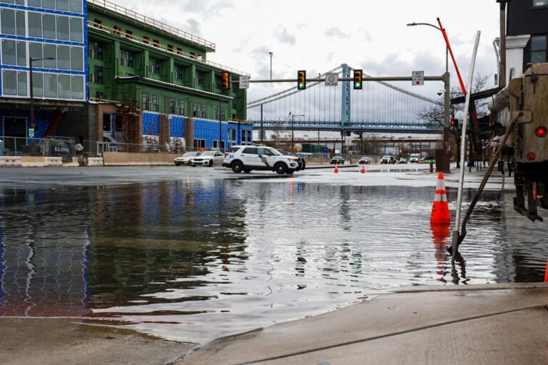
File photo: The Philadelphia Water Department worked to clear clogged gutters at Delaware Avenue and Spring Garden Street in Philadelphia cause road closures after a storm brought heavy rain to the region and the Delaware River overflowed onto the road on Dec. 18, 2023. (Kimberly Paynter/WHYY)
Have a question about Philly’s neighborhoods or the systems that shape them? PlanPhilly reporters want to hear from you! Ask us a question or send us a story idea you think we should cover.
Deadly wildfires, devastating floods, and historic heatwaves; 2023 brought another year of extreme weather to the United States.
The Philadelphia region saw its own share of historic weather — from extreme rainfall to a dearth of snow.
“That is all pointing to the impacts of climate change,” said Lauren Casey, a meteorologist with the nonprofit research organization Climate Central.
One of Philly’s warmest years on record
2023 was Philadelphia’s second warmest year on record through December 26, with an average temperature of 58.8° Fahrenheit.
The warmest year since records began was 2012, which averaged 59.2° F through December 26. Seven out of Philly’s 10 warmest years on record have occurred since 2000.
Globally, 2023 has been the warmest year on record. The global average sea surface temperature hit a record high this year, too. Scientists have cited El Niño and human-caused climate change as two contributing factors.
“Typically with El Niño we do see warmer temperatures globally on average,” Casey said. “Then you also are factoring in climate change, and we’re continuing to see warmer and warmer years as we … contend with all of the carbon that we put into the atmosphere from the burning of fossil fuels.”
Warmer oceans add heat and moisture to the atmosphere, Casey said, contributing to hotter air temperatures, and fueling storms and extreme rainfall.
Another reason for increasing temperatures in the Philly area over the last 150 years is urbanization, with the development of more heat-trapping surfaces over time.
“You have the buildings, the asphalt, the concrete — all of that kind of traps in the heat and re-radiates it back down to the surface in an urban environment,” Casey said.
Record low snowfall
Philadelphia is on track to end the year with just .3 inches of snowfall — the city’s lowest amount on record.
“Snow forecasting, it’s extremely complicated. It takes in many, many variables. But at the end of the day, … you basically need moisture and cold air,” Casey said. “And we’re just not seeing the cold air.”
Winter is the fastest-warming season in the Philly region, according to an analysis by Climate Central. Long term weather data shows that the number of days each winter that top 50° F in Philly has been trending up in recent decades.
As of December 26, the city has not gotten what Casey calls “measurable” snowfall — or more than .1 inches — in over 320 days. That’s the city’s third longest streak on record.
The Philly region had an opportunity for snow earlier this month, when a storm moved across the Northeastern U.S., said Gregory Jenkins, a professor of meteorology & atmospheric science at Penn State University. But the storm dumped rain, rather than snow. At least two people were killed when their vehicles were submerged in water.
“This is not typical, in my opinion, that we should be seeing those kinds of rain events, flooding events in December,” Jenkins said. “Normally, I would have expected someone to get snow out of that last system. The fact is, it was really too warm to support snow, pretty much anywhere.”
One reason for this is recent weather patterns, which have failed to bring much cold air from the Arctic down to the Philly region, Jenkins said.
“From a weather perspective, [warm air from] the south is winning … but in the background, we still have the fact that the overall planet is warming from greenhouse gasses,” he said.
Deadly flash flooding
Despite flooding that sparked warnings and road closures in Philly earlier this month, the city had a fairly unremarkable year in terms of rainfall. The city avoided major impacts from decaying tropical cyclones — after being walloped in 2021 by the remnants of Hurricane Ida and in 2020 by Tropical Storm Isaias.
“We lucked out in a sense, because many of these storms curved off towards the north before hitting the U.S.,” Jenkins said.
Government forecasters upgraded this year’s Atlantic hurricane season prediction to “above normal” in August, as the effects of El Niño developed later than expected and warm Atlantic sea surface temperatures — which can help hurricanes form — continued.
“Normally El Niño will limit the number of hurricanes because we see more wind shear, so it tends to break them up,” Jenkins said. “But as the summer went on, we started seeing tropical cyclones develop in the central and eastern Atlantic, [which] is typically not that normal. And they weren’t weak systems — they were strong.”
Other parts of the Philadelphia region did experience extreme rainfall this year.
In July, Washington Crossing, Pa. got roughly a month’s worth of rain in just two hours, causing flash flooding that led to at least six deaths. On a different day in July, more than five inches of rain fell in the Reading area, causing flooding that washed out an encampment downstream.
Heavy precipitation is becoming more common in the Northeastern U.S. as human-caused climate change warms the atmosphere, allowing it to hold more moisture. Development also increases flood risk, as parking lots, roads, and roofs prevent water from soaking into soil and instead send it rushing downstream.
Jenkins hopes people start paying more attention to climate-linked events and trends — like wildfire smoke, lack of snow, and heavy rain.
“We’ve got to watch out for those rainfall extremes,” Jenkins said. “Our cities, our infrastructure, they’re not built for this. … And we’re not ready for those kinds of events, either.”

Subscribe to PlanPhilly
WHYY is your source for fact-based, in-depth journalism and information. As a nonprofit organization, we rely on financial support from readers like you. Please give today.


