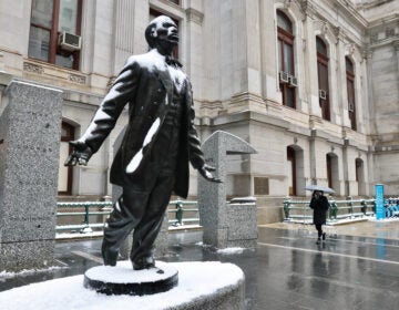
A potential winter storm is coming to Philly area this weekend
We're tracking a weekend Nor'easter that could bring a mix of rain and snow to our area.
This story originally appeared on 6abc.
Get outside and enjoy a nice, bright afternoon. We’re tracking a weekend Nor’easter that could bring a mix of rain and snow to our area.
WEDNESDAY: Mostly sunny and nice. High 46.
THURSDAY: It’s breezy with morning clouds and a flurry/sprinkle possible. High 45.
FRIDAY: Mostly sunny and cooler. High 41.
SATURDAY: It’s rather cloudy with an afternoon high of 40. We may start to see some light precipitation breaking out in the afternoon. We’ve issued an AccuWeather Alert for Saturday night for the heaviest rain/snow. Greater storm totals will be far NW.
SUNDAY: The heaviest rain/snow ends early and the winds begin to gust. The track of the low pressure will determine how much rain and snow we’ll see. We’ll have more details on that as models become more aligned. Any snow we do get will be heavy and wet with limited cold air. The greater storm totals will be farther NW. We’ll likely see coastal flooding with some heavy rain and strong wind at the shore. A weak disturbance may bring some additional light rain/snow showers around during the day. High: 39.
MONDAY: Partly sunny. High 43.
TUESDAY: Another storm moves through the area just as milder air pushes in. We have the potential for flooding if we see heavy rain. High: 49. Temperatures stay in the 40s overnight as rain continues.
WHYY is your source for fact-based, in-depth journalism and information. As a nonprofit organization, we rely on financial support from readers like you. Please give today.


