

Parkway or Turnpike? For first time, N.J. residents will get to comment on new legislative district maps before final vote
The Democratic and Republican redistricting plans had formerly been kept confidential until the Apportionment Commission made its final decision.

(Left to right): The Turnpike map vs. the Parkway map.
This story originally appeared on NJ Spotlight.
For the first time in modern New Jersey history, the public can see how Democrats and Republicans are planning to redraw legislative districts before a commission votes on a new map to govern state elections for the next decade.
“Here we are, an historic first,” said Henal Patel, director of the democracy and justice program at the New Jersey Institute for Social Justice and a member of the Fair Districts Coalition pushing for greater transparency in the process, including the release of maps before a final vote. “The Apportionment Commission deserves a lot of credit for releasing these maps at this point in the process, with time for public feedback before a map is confirmed.”
The maps, posted on the New Jersey Legislative Apportionment Commission website Monday, are named Turnpike and Parkway to try to keep partisanship out of discussion of the proposals, although it appears the Turnpike map embodies more Democratic goals and vice versa. The Parkway map would draw 24 districts with a Democratic advantage, 10 leaning Republican and six split, based on 2017 gubernatorial election results. The Turnpike map would give Democrats a 28-10 edge with two split districts.
Using 2017 gubernatorial results is misleading in many parts of the state, particularly South Jersey, where Republican Jack Ciattarelli did better last year than Kim Guadagno fared in 2017 and where the GOP flipped six seats in the Legislature. Currently, the number of registered Democrats is greater than Republicans in 29 of 40 districts. But Republicans have been elected to represent a number of those districts.
Related Content

Here’s how legislative and congressional redistricting works in N.J. — and what’s at stake
Two commissions are redrawing N.J.’s legislative and congressional district maps. There’s still time for the public to weigh in, so here’s what you need to know.
5 years ago
Listen 1:48Where the parties have an edge
The Parkway map looks to give Republicans an edge in two central Jersey districts both currently held by Democrats: the 14th, based in Mercer, and 16th, based in Somerset. The Turnpike map would make South Jersey’s 2nd District and 8th Districts, both split before Republicans took control of them last year, lean more Democratic.
Advocates and political observers hailed the posting of the parties’ plans, which had formerly been kept confidential until a final vote. But some warned about reading too much into the maps.
“The Turnpike map, in particular, may not be the Democrats’ best final effort,” said Patrick Murray, director of the Monmouth University Polling Institute. “Was there a political calculation made about what type of map you would want to show to the public to get feedback on before you submit your final map?”
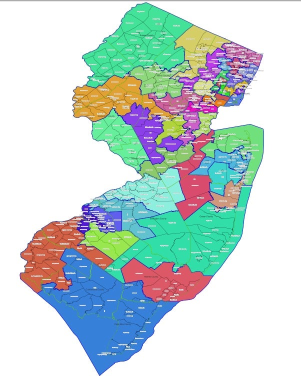
Murray said that, at first blush, the Turnpike map appears to be designed to protect as many incumbents as possible. The Parkway map, on the other hand, “looks like a map that you would potentially draw from scratch if you are not considering current incumbents” and is more compact in geography.
One reason why the commissions redrawing legislative and congressional boundaries previously have not released map proposals prior to a vote is to prevent incumbent lawmakers from complaining about alterations in the boundaries of their districts, including potentially being drawn out of the areas they represent, and lobbying for changes.
In New Jersey, commissions with equal numbers of Democrats and Republicans redraw the political maps each decade following the U.S. Census. Each commission has a tiebreaking member, given the unlikelihood that partisans will agree.
Releasing maps early
This year for the first time, a tiebreaker got the sides to agree to release maps early. Philip Carchman, a former Superior Court judge, announced last week that the legislative commission would post two maps on Monday and let the public comment on them on Wednesday, its last scheduled public hearing.
John Farmer Jr., director of the Eagleton Institute of Politics at Rutgers University who served as the tiebreaking member of the congressional redistricting commission a decade ago, supports Carchman’s decision.
“I think it’s a great idea, and particularly suited to our time, when maps no longer take extended periods of time to draw and recalibrate,” he said, noting that free online programs can allow anyone to draw legislative districts. “Public commentary may call attention to issues overlooked by the parties and the Chair, thus enabling adjustments that would have been impossible to make in prior decades. I would expect it to become standard practice in future redistricting cycles.”
Making proposed maps available for public comment has become commonplace in other states. Advocates had hoped the state’s congressional redistricting commission, which completed its work shortly before Christmas, would do that, but it did not. The new boundaries of the state’s dozen House districts were drawn by Democrats. Republicans sought to overturn that map based on the reason given at the time by 13th member John Wallace, a former Supreme Court justice, but last week the state Supreme Court dismissed that challenge.
Related Content

Murphy taps his chief counsel, Matt Platkin, to serve as N.J.’s next attorney general
Platkin will begin serving as acting attorney general on Feb. 14. The Senate must confirm his nomination before he can officially serve in the role.
4 years ago
Flaws, areas of concern
The legislative maps unveiled Monday have flaws, which Patel and others plan to point out to the commission Wednesday.
“I think both parties made some choices that are good, and some that are concerning, and I hope that they can and will be corrected by the time a map is certified,” she said. Among the concerns are that both maps break up some “communities of interest” or areas that have common needs and that residents want to be kept in the same district, and both “I think, they continue to overrepresent white communities.”
The Parkway and Turnpike maps create no more than 17 districts where the majority of the population is non-white, and each creates only one majority Black district and one majority Hispanic district. The Fair Districts Coalition, by contrast, submitted a map where half the districts were majority people of color districts, including three majority Black districts and four majority Hispanic districts.
Carchman said last week he expected these maps would undergo further changes before each party submitted its final proposal to him. Then behind-the-scenes negotiations are likely to ensue between Carchman and the Republican members led by Al Barlas, chair of the Essex County Republican party, and the Democrats led by LeRoy Jones, who chairs the state Democratic committee. The five-member Democratic contingent no longer includes former Senate President Steve Sweeney, who last week lost his court bid to be returned to the panel after Jones ousted him two weeks ago and replaced him with Laura Matos, providing the only Latina representation on the 11-member body.
The commission’s final hearing is virtual only, scheduled for 6 p.m. Anyone who wants to testify can do so by registering on the state Office of Legislative Services’ website. The public can watch the meeting online, as well.
Never miss a moment with the WHYY Listen App!
Never miss a moment with the WHYY Listen App!
WHYY is your source for fact-based, in-depth journalism and information. As a nonprofit organization, we rely on financial support from readers like you. Please give today.

Inability of Murphy, Senate to speed judicial appointments is ‘appalling’
State bar association president says governor should try same strategy he used to halt strike at Rutgers University.
3 years ago

N.J. Gov. Murphy orders big jump in offshore wind
Governor boosts goal for green power, key to carbon-free target.
4 years ago

New N.J. budget: A look behind the numbers of $50.6B spending proposal
Largest spending plan in state history funds school construction, pension obligations, tax relief — and lawmakers’ pet projects
4 years ago