


Sizing up history of the SugarHouse site

Torben Jenk
Jan. 16
By Kellie Patrick Gates
For PlanPhilly
Armed with copies of old, drawn-to-scale maps, a ruler, and the knowledge that one fathom equals about six feet, preservationist Torben Jenk points to green street signs about a block away from the proposed SugarHouse Casino site.
“That’s the intersection of Canal and Laurel,” he said. “Six hundred feet from there, in the line of Laurel Street, is about where the center of the fort would be.”
The fort Jenks speaks of is British Fort No. 1. The British used it during the Revolutionary War occupation of Philadelphia, placing it near Frankford Avenue to guard the important food supply line from loyalist farmers in Bucks County.
At a 10 a.m. meeting Friday, Jenk and other historians and history buffs will try to convince the Army Corps of Engineers to require a more thorough archaeological exploration of the SugarHouse site before granting casino developers a permit they need to move forward with construction.
SugarHouse representatives will try to convince the Corps that the work done by their archaeological contractor – A.D. Marble of Conshohocken – has been extremely thorough, and that Marble’s conclusion that any artifacts left from the fort were destroyed during the Industrial Age are on target.
“We have full confidence in our archaeological consultant,” SugarHouse spokeswoman Leigh Whitaker said in an email conversation last week. It would be inappropriate for SugarHouse to detail what they will tell the Army Corps prior to the meeting, she said.
Jenk is not convinced there’s nothing to be found, especially since it appears to him that at least a portion of the fort was not under any building, but beneath railroad tracks that served both the former sugar refinery and the former Shackamaxon Freight Co. “Train tracks have no foundations,” he said, so whatever lay beneath would not have been greatly disturbed.
Friday’s meeting is likely the first in a series between the Corps, SugarHouse, the Pennsylvania Historical and Museum Commission and the consulting parties, including Jenk. Federal law requires the historical review before the issuance of a permit that allows SugarHouse to build into the Delaware River. The Corps issues the permit, but must also consider the advice of the Historical Museum Commission and the interested parties who asked to be consulting parties.
Some anti-casino activists and politicians who want the casinos to be built away from the waterfront see the history of the site as a weapon in their arsenal.
But Jenk says he does not care if a casino goes up on the site, provided the history that could lie beneath it is dug up first. He has spent many hours over the past several weeks looking at historic maps and diary accounts, trying to piece together as much information as possible and send it to other historians, the Corps, the Commission and SugarHouse officials.
Marble’s first phase report made no mention of the Fort because Marble didn’t know it existed. Learning that sent Jenk, Northern Liberties Neighborhood Association member Hilary Regan, Penn Treaty Park director John Connors and others into historic research overdrive.
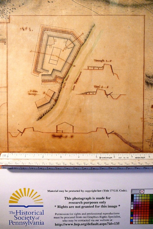
On Wednesday, Jenk showed one map of the site created by Lewis Nicola and another by a spy for George Washington whose last name was Fleury.
The finely detailed map by Nicola shows the fort was surrounded by 153 12-foot logs, sharpened at the top. A moat ran around the three sides of the fort that did not face the river. That moat flooded with the tides, which meant it was either filled with water or was very muddy – except in winter, when it would be icy. “It would be like attacking a hedge hog while standing on ice,” Jenk said.
The map shows those sharpened logs continuing into the water, and Jenk imagines any boat that tried to attack from that side – the one not defended by a cannon – would have been caught up in them.
Nicola’s drawing shows a barracks in the middle of the fort, and it is that barracks that interests nationally known historian Bob Selig, who believes colonial loyalists posted at the fort likely had their families with them, and perhaps articles belonging to women and children could also be found.
A preliminary phase II report completed by Marble mentions a shaft lined with barrels, stacked one upon the other.
“This is a technique the British used during the 17th Century in the Caribbean to line a well,” Jenk said. “I’m not saying that’s what this is – I’m not qualified to interpret it – but I’m willing to share that information so that the real, proper scientists can interpret the evidence,” he said.
WHYY is your source for fact-based, in-depth journalism and information. As a nonprofit organization, we rely on financial support from readers like you. Please give today.
Brought to you by PlanPhilly

PlanPhilly
In-depth, original reporting on housing, transportation, and development.

Cobbs Creek movie palace may join Philadelphia’s historic register
The Ambassador Theatre in Southwest Philadelphia is one of the few remaining buildings in the city that once housed a neighborhood theater. It could now become a landmark.
2 weeks ago
Listen 0:50
A rare Keith Haring mural in Point Breeze may join Philly’s historic register
The “We the Youth” artwork revives a long-running debate among preservationists over whether murals should be protected as historic landmarks.
4 weeks ago
Listen 0:54
Henry Tetlow helped shape America’s cosmetics industry with more affordable — less caustic — face powders before his company collapsed into a family feud.
3 months ago