

No easy fix for flooding in NJ’s back bays
Report details the impact of possible solutions as sea levels rise

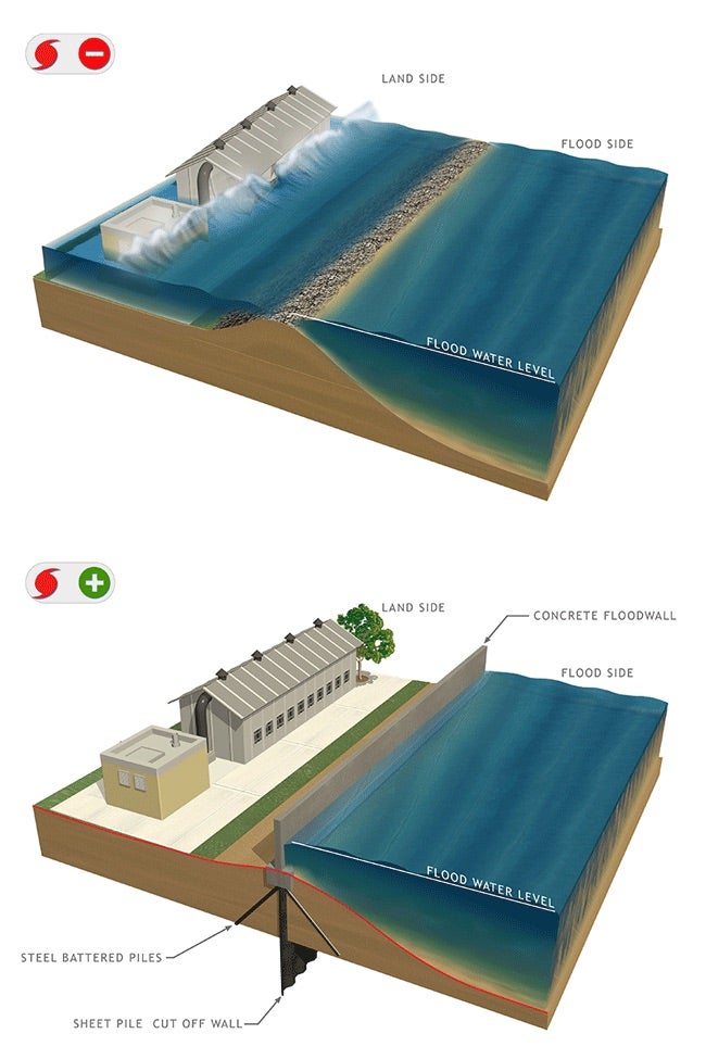
Among the risk-management measures under consideration are storm surge barriers that would be closed during heavy storms. (U.S. Army Corps of Engineers)
This story originally appeared on NJ Spotlight.
In the wake of Superstorm Sandy, the Army Corps of Engineers has been studying New Jersey’s 3,400 miles of back-bay shoreline to determine flood risk and look for possible structural options to mitigate the coming damage from rising sea levels.
On Thursday, the Corps published an update to its “New Jersey Back Bays Study,” this time focusing on the feasibility and environmental impact of a tentative plan for structural solutions.
New Jersey’s back bays are already one of the nation’s most flood-prone regions. And Thursday’s report noted that the possible cost of doing nothing to minimize the increased risk of flooding now stands at an average of $1.8 billion in annual damages over a 50-year period.
“The potential solutions to back bay flooding are complex,” the Corps’ Philadelphia District commander, Lt. Col. Ramon Brigantti, said in a news release accompanying the report Thursday. “But there is a clear need to consider and evaluate all options and that’s what the New Jersey Back Bays Study aims to do.”
“The study is taking a broad look at storm-related flooding across a large geographic area,” added Steve Rochette, public affairs officer for the Corps’ Philadelphia District. “In order to cost-effectively reduce storm surge related flooding that pours into back bays through the coastal inlets, we considered large-scale potential solutions like the storm surge barriers. At the same time, the measures already taking place at the individual level, local level are essential to reducing risk as well.”
Solutions could have negative environmental impacts
Some of the starkest findings in Thursday’s report can be found in its overview of the potential environmental impacts of possible measures to contain storm surge events and the rising sea.
Structures like storm surge barriers and cross-bay barriers are considered “high risks” for aquatic ecosystems, from impacts on species habitats to wetlands loss and reductions in water quality. Other potential protections, like flood walls and levees, would also negatively affect wetlands and aquatic species. The Corps estimates that the structural components of its “Tentatively Selected Plan” would “directly affect over 153 acres of aquatic habitats, which includes about 60 acres of subtidal soft-bottom habitats, about two acres of intertidal mud/sand flats, about nine acres of intertidal sandy beach, and 73 acres of low and high saltmarshes.”
Because of these impacts on the marine environment, the report says, “a compensatory mitigation plan is being developed that will account for the functional losses of ecosystem services that these habitats provide.”
And just as the aquatic environment would change, so too would the human. There would be both “temporary and permanent” adverse visual effects, and some historic properties would also be impacted. Nature-based measures — like the use of oyster reefs and dredged material to build up eroded shorelines — would, of course, be the least intrusive, as well as provide some mitigation for habitat losses.
Related Content

‘Bottom-up’ plan underway to catalogue N.J.’s vulnerable coastal communities
The Department of Environmental Protection is increasingly focusing on the roughly 1,800 miles of tidal marshes, estuaries and back bays of New Jersey’s coastal zone.
4 years ago
Rising water, sinking land
The initial feasibility report, published in March 2019, took a sweeping view of the problem: Since the beginning of the 20th century, sea level along the New Jersey coast has risen by about 18 inches, due to a combination of rising water and subsiding land. By the end of this century, according to the New Jersey Climate Change Resource Center at Rutgers University, sea levels will have risen at least another foot.
To tackle the problem, a dizzying array of scenarios with a multitude of combinations of structural, nonstructural and nature-based measures has been presented.
The Army Corps hosted a series of public meetings following the initial report’s release, oftentimes eliciting serious concerns from coastal residents and homeowners. Thursday’s updated report reflects much of that feedback, and the result is a smaller, more refined set of structural suggestions.
Possible fixes
At the heart of the report is the “Tentatively Selected Plan,” which the Corps says is “preferable to taking no action or implementing any of the other alternatives considered during the planning process.” The plan includes the following conceptual features:
- Storm surge barriers — structures that span waterways and consist of movable gates that stay open during normal conditions but close during storm surge events, like hurricanes (of between 17 and 20 feet above mean sea level) — have been recommended for Manasquan Inlet, which divides Manasquan and Point Pleasant Beach; Barnegat Inlet, between the northern tip of Long Beach Island and the southern tip of Island Beach State Park; and Great Egg Harbor Inlet, between Ocean City and Longport.
- Cross-bay barriers have been recommended for Absecon Boulevard/Route 30, which threads the marshland behind Atlantic City, and a back-bay stretch of 52nd Street in Ocean City. These are structures similar to levees, and they would be located in interior bay areas, often adjacent to existing roads, and have sluice gates to allow for the passage of boats and flow of water.
- Other “perimeter measures” could be flood walls, levees and sea walls that tie the storm surge barriers and cross-bay barriers to nearby areas of higher ground.
- The elevation of 18,800 structures, both homes and business — 135 in Monmouth County; 8,567 in Ocean; 66 in Burlington; 1,491 in Atlantic; and 8,579 in Cape May.
The cost of the three recommended storm surge barriers and two cross-bay barriers alone would be $16 billion, with the federal government picking up 65% of tab and the state and impacted counties and municipalities splitting the difference — an arrangement similar to the beach replenishment projects currently being implemented by the Corps up and down the Jersey Shore.
“I have to say that the ‘Tentatively Selected Plan’ is much less intrusive than some of the earlier concepts,” said Tom Herrington, associate director of Monmouth University’s Urban Coast Institute. “The Corps clearly listened to the public comments.”
Nature-based solutions
The plan also notes that nature-based features, such as restoring wetlands and fortifying shorelines using dredge materials and structures like oyster reefs, could be “added to the plan in the future.” Another future consideration could be “non-structural” measures — National Flood Insurance Program refinements; retrofitting buildings to reduce risk of damage from flooding; public awareness campaigns; and managed retreat, which could include zoning changes, easements, home buyouts, and eminent domain.
“Certainly, regional long-term planning should start to incorporate thoughts about how we de-densify the coast,” Herrington said. “Municipalities just don’t look that far out into the future, especially with significant uncertainty related to future storm frequency and long-term sea levels. Plans and policies at the state, county and regional levels that can help us sustain our coastal ecosystem in the future and claw back from the coast when necessary should be discussed and made over the next decade.”
The Corps emphasized that the “Tentatively Selected Plan” is subject to change, and that it has not yet been approved by Congress or funded for implementation.
The “New Jersey Back Bays Study” came about in the wake of Superstorm Sandy, when it became clear that the back bay regions of New Jersey were significantly underprepared for the kind of flooding that Sandy’s storm surge brought, as well as lacking any kind of cohesive infrastructure that could reduce risk to life and property across municipalities.
The 950-square-mile study area encompasses over 674,000 permanent residents and hosts millions more primarily during the three-month summer season, translating to over $40 billion in annual gross domestic product, according to the report. The asset inventory of the region, which equates to 182,930 structures, is worth more than $72 billion.
For all its value, however, this slice of New Jersey is among the most flood-vulnerable regions in the United States. According to the National Oceanic and Atmospheric Administration’s National Climatic Data Center, since just 1996, the state has experienced 1,169 flood events.
The cost of insurance claims
The report goes on to note that, according to National Flood Insurance Program statistics, “flood claims payouts [in New Jersey] have totaled more than $5.3 billion since the beginning of the NFIP program in 1978 through July 2013. Out of that, nearly $2.9 billion was paid for flood damages to the coastal counties of Monmouth, Ocean, Atlantic and Cape May from Hurricane Sandy damages alone.”
Currently, the costs of the back bays study are just over $18 million, which is split between the New Jersey Department of Environmental Protection and the federal government. Following the release of Thursday’s updated report, the Corps will host virtual public meetings on Sept. 20 and 21. The agency hopes that the feasibility portion of the study will conclude in 2023, with a recommended plan for construction authorization and Chief of Engineer’s report. The earliest that any construction could start, Rochette said, would be 2030.
In an interview with NJ Spotlight News in May, Department of Environmental Protection Commissioner Shawn LaTourette was asked about the massive scale of the back bays study. He recalled an analogy that one of his counterparts in the Pacific Northwest had recently made.
“She said, ‘There’s no silver bullet, it’s silver buckshot,’” LaTourette said. “We’ve got to look at this as some types of solutions in one place and other types of solutions in another. It’s not going to be the case that we pick up whole communities and move them inland. That won’t be necessary in all spaces, but we need to consider where it will and won’t be with what we’re building today, because we know better.”
Never miss a moment with the WHYY Listen App!
WHYY is your source for fact-based, in-depth journalism and information. As a nonprofit organization, we rely on financial support from readers like you. Please give today.

Trenton receives a $4M grant to redevelop and reopen old downtown hotel
Trenton gets a $4 million grant to buy the former Trenton Marriott building. The plan is to redevelop the property and open a new hotel.
8 months ago
Listen 1:10
Pa., N.J., and Del. among 16 states suing USPS over lack of electric vehicles
The Postal Service’s plan to replace about 165,000 of its gas guzzling delivery trucks includes just a fraction of EVs. Now, Pa., N.J., and Del. are among 16 states suing.
3 years ago
Listen 5:35
Penns Grove hopes to turn vacants into value by auctioning borough-owned properties
The small borough in Salem County, N.J. hopes properties sold at auction will be added back to the tax rolls while generating some money to plan future projects.
3 years ago