Mapping Philly’s most walkable neighborhoods
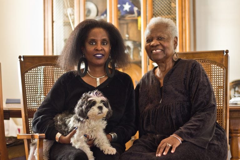
Ann Strickland, 87, has lived in the southwest corner of Eastwick for 37 years.

Lisa Strickland and her mother Ann say they love their Eastwick neighborhood. (Kimberly Paynter/WHYY)
This story originally appeared on PlanPhilly.
—
Ann Strickland, 87, has lived in the southwest corner of Eastwick for 37 years.
Her small community of single-family homes sits right across from the John Heinz National Wildlife Conservatory at Tinicum.
Not far from Philadelphia International Airport, the area is isolated, and barren of the attractions that line the streets in busy parts of the city, where residents can have most of their needs met without getting behind a steering wheel, or summoning someone who is.
Which is why an online tool from New York University School of Medicine shows that Strickland lives in the least walkable area of the city. The City Health Dashboard rated the area southwest of the Bartram Avenue and 84th Street intersection, part of the 19153 zip code, three out of 100 on the scale of walkability.
The metric quantifies the “density of intersections and residences” and accessibility to places such as grocery stores, parks, and restaurants.
Strickland, who lives with her daughter Lisa, 56, doesn’t mind getting in the car when she needs to pick up groceries, or medicine from the pharmacy. She and her daughter both like to drive and enjoy the privacy of living in an area with little foot traffic.
“The whole time we’ve been out here it’s been really nice,” she said.
Eastwick isn’t the only section of Philadelphia to rank low on the walkability scale. Other areas with ratings below 10 include parts of Girard Estates and Packard Park in South Philadelphia as well as Somerton, Millbrook and Bustleton in the Northeast. According to researchers, areas like these tend to have higher rates of obesity and diabetes than places that are more pedestrian-friendly.
Not surprisingly, the most walkable sections of the city — several census tracts scored perfect 100s, and many ranked above 90— can be found in Center City and include Rittenhouse Square, Fitler Square, Logan Square, and Society Hill, where residents pay a premium for commutes that can be traveled on foot.
Citywide, Philadelphia scored 79 out of 100, compared to an average of 42.8 across the 500 U.S. cities included in the NYU dataset.

In addition to walkability, researchers mapped health indicators including opioid overdose deaths, obesity, housing affordability, teen births, income inequality, and more.
The tool was released with the support of the Robert Wood Johnson Foundation.
“We hope that this data is going to spur action and target intervention in these locations and also the allocation of resources,” said Oktawia Wojcik, a program officer at the foundation.

Lisa Strickland said she tried walking for exercise but was never able to find the right route in her spread-out, sparsely populated neighborhood.
“The problem that I found with walking was there wasn’t enough trees,” said Lisa. “There wasn’t the comfort of trees to have the cool shade or the breeze in the summertime.”
Eastwick lost thousands of homes and businesses in a failed 1950s urban renewal effort.
Over the past few years, the Philadelphia Redevelopment Authority developed plans to bring more activity to the area. The latest feasibility plan shared with Eastwick residents included proposed changes to the nearly 130-acre parcel of land on which Strickland lives. Envisioned for the future is a denser neighborhood where shops and businesses could coexist with the home there now. A walk to the grocery store or the pharmacy could indeed be in the Stricklands’ future — welcome news to the family.
“It’s a good area, and it’s going to be growing up in a few years,” said Ann Strickland.
WHYY is your source for fact-based, in-depth journalism and information. As a nonprofit organization, we rely on financial support from readers like you. Please give today.


