Why more and more homes are getting taller in Ocean City, N.J.
Many more homes are being lifted above expected future flood heights, or razed and replaced to comply with newer, more stringent flood protection standards.

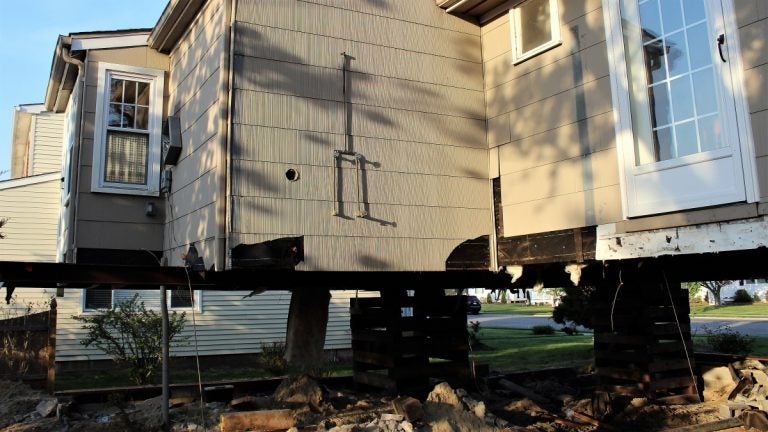
The author's home in the process of being elevated 5 feet higher. (Bill Barlow/for WHY)
A combination of market forces, local ordinances, and rising costs for coverage under the National Flood Insurance Program, administered under the Federal Emergency Management Agency, has meant more and more homes are either being lifted above the expected height of future floods, or razed and replaced by new homes that meet the newer, more stringent flood protection standards.
This week, the eyes of the nation are on Hurricane Maria, which made a direct hit on Puerto Rico. Its projected path could bring it close the southeastern United States. This has been an intensely active and damaging hurricane season in the Atlantic Ocean with Hurricane Harvey hitting Houston and Irma wreaking havoc in Florida. All of these areas suffered damaging flood waters to homes and businesses.
But like New Jersey after Superstorm Sandy, the flood waters will eventually recede, leaving homeowners facing tough questions on how to rebuild or even whether to rebuild.
Changing codes, changing economics
Five years ago, Superstorm Sandy slammed the Jersey shore, and reshaped the reality of coastal living. In many cases, homeowners looked to federal grant programs to help fund the work. What was once an unusual sight has become commonplace on the barrier island communities that make up most of New Jersey’s coast. Crews break a building from its foundation, jack it into the air and then rebuild the foundation around it.
In Ocean City, New Jersey, 127 homes have been elevated since Sandy. Hundreds more have been demolished and replaced by new construction, which must meet the new standards. Frank Donato, Ocean City’s emergency management coordinator, described it as putting the first floor of most homes in the town up one flight of stairs. Before, most homes were up a half a flight of stairs or less, and some were built on a slab at ground level.
In the coming years, there will likely be fewer and fewer properties on the ground, and not just because of the increased cost of flood insurance. The city has passed an ordinance mandating not only new construction be built two feet above base flood elevation; houses undergoing major renovations must meet the same standard.
The calculation of whether to fix or rebuild comes down to this. Will the repair bills exceed 50 percent of the assessed value of the home? While most think of the assessed value as what the home and land are worth, in this case the key number is 50 percent of the assessed value of just the building.
If the repairs will cost more than half that value, then under Ocean City rules you have to elevate the house to meet the latest height requirement.
So for a home that might sell for $500,000 on the market, the building may be assessed at $100,000. In this case, if it will cost you more than $50,000 to repair your home you will have to pay even more to have it lifted. That could cost you anywhere from $30,00 to $100,000 in the current market.
For many older homes, it will be cheaper to demolish and start over than it will be to repair the home and lift it.
Flood insurance reform
Soon after Sandy, something happened that will shape coastal communities for years to come. Approved before the storm, the feds began a long process aimed at moving flood insurance rates through the subsidized National Flood Insurance Program closer to the actual market costs of those policies.
The NFIP began in the 1960s, aimed at keeping shore communities viable as private insurance companies pulled away from offering flood insurance. Rates were kept artificially low in the program. According to Michael McMahon of the McMahon Insurance Agency, who specializes in flood claims, most of the biggest claims were being paid to property owners with subsidized policies, sometimes over and over again.
Owners are likely to see their flood insurance costs skyrocket in the coming years as new rates are phased in, and those buying a home will see a far more expensive flood insurance bill, unless the home is elevated above likely flood damage.
That changed the economics of lifting houses, a formerly obscure branch of construction that has seen a boom recently. Along with the availability of grants to help cover the costs for many homeowners, that meant house lifting became big business.
Big money, and big headaches
The Rehabilitation, Reconstruction, Elevation and Mitigation program, or RREM, gave homeowners up to $150,000 to repair damaged properties and lift their homes above future floods. Grants could also be used to help cover the costs of demolishing and building new houses that meet current flood elevation codes.
In cases where the damage was more than 50 percent, the program included a requirement to lift above the expected height of the worst flooding. Funded through the federal government and run by the state, RREM was a lifeline for many homeowners who faced a stark choice: lift, or lose a substantial portion of the value of their homes, as potential buyers could face big insurance bills or taking on the cost of meeting new flood zone rules.
“Because of the RREM Program, thousands of program-eligible homeowners who suffered great losses to their primary residence as a result of Superstorm Sandy have been able to rebuild their homes,” said Lisa M. Ryan, the communications director of the Sandy Recovery Division for New Jersey’s Department of Community Affairs, in a statement prepared in response to a request for an interview for this story. ”These are generally homeowners who, without RREM assistance, wouldn’t have been able financially to rebuild or would have been forced to take on significant debt in order to rebuild. The RREM Program has made it possible for them to rebuild safer and smarter,” she wrote.
“Also, the program has provided stability to communities impacted by Sandy by enabling families to stay in their neighborhoods and it has contributed to more sustainable housing stock by helping people elevate their homes out of harm’s way and incorporate green building and energy efficient technologies.”
The program has reshaped many shore neighborhoods, bringing houses above the Federal Emergency Management Agency’s base flood elevation. Most of the planning is based on potential future storms. For instance, a 100-year storm is a storm so serious there is a one percent chance of it hitting in a given year.
“When a house is properly elevated, the living area will be above all but the most severe floods (such as the 500-year flood),” reads a statement on elevation from FEMA.
The program has meant thousands of homes damaged by Sandy are now markedly safer from flood damage. “Of the approximately 7,600 homeowners in RREM, 5,407 have completed construction and the remainder are in construction, with more than 700 of those in construction reporting to DCA (the state Department of Community Affairs) that they’ve returned home. To date, approximately 4,600 homeowners in RREM have completed elevation of their home and another 2,000 are in progress,” stated Ryan. “Not all homes in the RREM Program must be elevated. Only homes that are determined substantially damaged (i.e., damage equaling more than 50 percent of a home’s pre-Sandy value) by their local flood plain administrator must elevate. If a home is non-substantially damaged, the homeowner does not have to elevate, although they can voluntarily elect to do so, which many have.”
Hard hit towns see progress
A large portion of those 2,000 homes still in progress are in Ocean County, where wind and water did huge damage along the coast, and inland in bayside communities like Stafford Township behind Long Beach Island. The mainland community was among the hardest hit areas.
John Spodofora, the township’s mayor, grew up in the area, and has seen plenty of storms hit, including the devastating March, 1962 nor’easter that reshaped New Jersey’s coastline. He’s served on Township Committee for years, and was elected mayor in 2011, a year before Sandy hit. He said the town lost about $200 million worth of ratables in Sandy, meaning that was the assessed value of homes and properties lost overnight. That included more than 4,000 houses damaged in the flood water. About 3,000 of those were listed as substantially damaged, meaning repairs would cost more than half the value of the home.
In the five years since, the residents have moved back, the businesses are up and running, and the total real estate assessments for the town is all the way back to pre-storm levels, he said. Through RREM and other grant programs, about 70 percent of the homes that were significantly damaged have either been demolished and rebuilt, or lifted well above the highest water likely to hit the township for the foreseeable future.
But 30 percent of those owners are still waiting to finish the work so they can move home and put Sandy behind them.
Other changes
According to Ocean City’s Donato, towns often see a sharp loss in value after a storm, but then a quick recovery. In many cases the houses that are rebuilt after storms are more expensive than what they replaced.
As FEMA works on its maps of the flood hazard zones, the latest version shows most of Ocean City and other barrier island communities in one or another of two zones, the A zone, which would likely flood in a 100-year storm, and the V zone, meaning the velocity zone, which would likely see properties hit by waves in such a storm, with a much greater potential for damage. That zone calls for more stringent construction, with buildings designed to handle getting hit by waves.
A new zone is also expected, an X zone, which appears to be above the likely flood water. Some neighborhoods stayed dry through Sandy and other storms, but Donato said the city still wants new construction built to the standards of the nearest A zone, which means taller buildings all over town. Gradually, the city and other shore towns like it will see more buildings above future floods. The elevations are based on sea level, not on the ground level of the surrounding area, so in some low-lying areas, that could mean an 11-foot flood elevation, plus Ocean City’s requirement of two additional feet, could put the first floor of some homes 13 feet above the street level.
According to McMahon, any property could face a flood, regardless of the zone. “It doesn’t matter if you’re in Cherry Hill or Ocean City. The issue is the risk level,” he said.
WHYY is your source for fact-based, in-depth journalism and information. As a nonprofit organization, we rely on financial support from readers like you. Please give today.


