New SugarHouse archaeological report

July 10
By Kellie Patrick Gates
For PlanPhilly
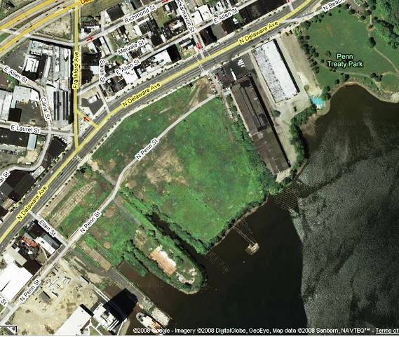
SugarHouse Casino’s latest archaeology report (see attached PDFs below) says much of the property that is now dry land was once beneath the Delaware River.
That finding excites both local historians and the elected officials involved in a battle with the casino over the right to build on state-owned, riverbed land.
The historians and the president of the Philadelphia Archaeological Forum say knowing where the water was means knowing more precisely where waterfront buildings – including a British Fort – once stood. That should help focus additional digging, they say.
But the report, which details work done by consultant A.D. Marble and a soil scientist, says further searching for the fort is futile. Extensive excavating for the fort has already taken place, the report says, and it is clear that any remains were destroyed by the building and demolishing of industrial sites that followed. A trove of Native American artifacts have already been recovered on the site. But the latest round of digging – which took place in May – makes it clear that the soil that might have contained other artifacts was also heavily disturbed to the point that any others would be destroyed, the report says.
“We are confident in the results of our actual geomorphological investigations, which have concluded that there is no evidence of the fort remaining on our site,” spokeswoman Leigh Whitaker said.
The April dig also seems to have satisfied the Advisory Council for Historic Preservation, the federal agency tasked with overseeing the protection of the nation’s historic resources. After completing a review of Marble’s work Thursday afternoon, The ACHP said the recommendations it made in June had been satisfied, and it was now up to the Corps to determine how to proceed. Whitaker said SugarHouse would not comment on the ACHP’s decision until it received official word of it.
Riparian issues
A.D. Marble’s report says the Delaware River shoreline used to be just east of Penn Street, a considerable distance from the current place where solid land meets the river.
This delights Rep. Mike O’Brien, one of a group of local and state officials who want to convince the casino to build somewhere else. O’Brien said the dirt that lies between the historic river’s edge and the current one is fill, and that fill is owned by the state. SugarHouse cannot build on it, he says, without legislative approval. “That site now becomes very narrow, and very long,” he said. “Simply put, without the granting of riparian rights, it can’t be developed.”
SugarHouse disagrees with the assessment that finding the old edge of the river has anything to do with its modern fight to build on the site, which it owns.
Anything involving casinos is never simple, and this is no exception. SugarHouse was granted riparian rights, also called a submerged lands license, by the city’s Commerce Department during the Street Administration. The new administration revoked the license shortly after Mayor Michael Nutter took office. First they said the procedure had been faulty. Then they decided that they disagreed with the former city solicitor’s assessment that a 1904 law gave the city the right to issue such a license in the first place. That right, for a project the size of SugarHouse, belongs only to the state legislature, the Nutter administration says. The legislature agrees.
SugarHouse attorneys, who found the 1904 law and brought it to the city’s attention, maintain that it indeed gave the city the right to grant a riparian license, and that Nutter had no right to revoke it. The legislators, including O’Brien, Rep. Bill Keller and Sen. Vince Fumo, say that the 1904 law only gave the city the right to grant licenses for water-borne commerce, not casinos. And that it was superceded by the Dam Safety and Encroachment Act, passed by the legislators in the 1970s. SugarHouse attorneys say the 1904 law still stands.
The State Supreme Court has yet to rule in a case that will determine both if the city had the right to issue the license and if it had the right to revoke it.
But O’Brien says even if the Court upholds SugarHouse’s license, it applies only to the land between the bulkhead and the pier-head – the spot beyond which piers cannot extend because they would invade the shipping channel. So SugarHouse would need to get legislative approval to build on the additional land, he said. “We would still have an issue between the bulkhead and Penn Street.”
It’s likely the courts will ultimately decide whether the historic river’s edge has an impact on riparian land leases. O’Brien has already said that if the State Supreme Court finds in favor of SugarHouse, he will likely try to get the U.S. Supreme Court to consider the case as a state sovereignty issue. Thursday, he said that the definition of riparian lands used when the city granted the license to SugarHouse was faulty, and that a Supreme Court case from the 1800s defined riparian lands according to the position of the river when the Commonwealth was founded. O’Brien intimated that this, too, might be a matter for the U.S.’s top court to review.
SugarHouse had no comment about O’Brien’s allegations regarding the river’s edge.
History
While the lawyers and judges figure out the riparian lands issue, the history of the SugarHouse site is largely in the hands of the Philadelphia Division of the Army Corps of Engineers.
The historic review is necessary because SugarHouse needs a federal permit from the Army Corps to build its project as planned. The Philadelphia division asked the federal Council for Historic Preservation for its advice, and the Council in June recommended more searching for the fort and the river’s edge. The Corp received the ACHP’s letter on the same day it received Marble’s report.
ACHP staff completed a review of the report Thursday afternoon.
“We have reviewed the report, and while we have not yet discussed its findings with the Corps or the Pennsylvania State Historic Preservation Officer, it appears that it substantially addresses the issues we raised in our June 25, 2008 letter to the Corps,” Bruce Milhans, an ACHP spokesman, said in an email.
Another of the ACHP’s recommendations was that the Philadelphia Corps office bring in an archaeologist to help them. Skipper Scott from the Ft. Worth, Texas division of the Corps is now reviewing the reams of documents from this case. This includes the recommendations from the local neighborhood activists, historians, archaeologists and others who are serving as advisors – or consulting parties, said Corps spokesman Khaalid Walls.
“Assuming the Corps will soon be in a position to make a finding whether the applicant has made a “reasonable and good-faith effort” to identify historic properties, as required in our regulations, the next steps would be to determine the eligibility of the properties for listing in the National Register of Historic Places, assess project effects to those found eligible, and then work with the consulting parties to determine how best to reduce or mitigate those adverse effects,” Milhans said.
The Corps will not make any decisions regarding archaeology work at SugarHouse until Scott completes his review, Walls said. Walls said there was no timeline for when that might happen.
The consulting parties will also continue to have a say, and some of them are calling for much more work.
Amateur historian and professional preservationist Torben Jenk said that Marble is using a 1777 map that is inaccurate. It was not created by someone who saw the site, he said, but by someone who was in England, had never been here, and was making a map not for practical purposes, but to sell to English people who were fascinated by what was happening in the New World.
In short, Jenk said, SugarHouse is not finding the fort because they are not looking in the right place.
“The new report, I think, continues their whole contention that they’ve done enough, and it’s not worth looking. I’ve said it from the beginning, and I’m still saying it: They don’t want to find anything.”
“All of the maps referred to as part of the Section 106 process are accurate,” Whitaker said.
Jenk and Douglas Mooney – the Archaeology Forum president – say SugarHouse has not looked at all for Batchelor’s Hall – a social club where John Bartram is thought to have tended a garden and to which many of Ben Franklin’s compatriots belonged.
Jenk said based on historical maps, the hall was located between two areas where Marble dug. The space between them is about 100 feet, Mooney said, and the hall was about 30 foot by 30 foot.
The report does recommend more digging in one area, where a square shaft-feature was found. The shaft was different from all others in shape and construction, and it contained cloth and other artifacts which the report says may be significant.
Mooney said that just the discovery of this shaft proves more digging is needed in this area – labeled as H2 on Marble’s maps of the dig. This is the largest area of archaeology, a long narrow swath between Delaware Avenue and Penn Street.
“The previous HSP gaming stance has been that in area H2 there has been sufficient disturbance that privies and what not are likely not to be there, and that no more work was necessary because there was no chance of finding anything,” he said. “In this supplemental testing, they found seven additional shaft features in that area, and one has been recommended for (complete) excavation. There is probably a large number of additional shaft features still within that section of the site, and they need to look for them.”
Contact the reporter at kelliespatrick@gmail.com
WHYY is your source for fact-based, in-depth journalism and information. As a nonprofit organization, we rely on financial support from readers like you. Please give today.


