Hurricane Lee, now very large, is raising wind and surf dangers along the East Coast

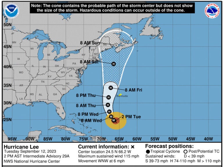
Hurricane Lee is currently moving at a very slow forward pace, but the storm is expected to turn northward and gradually accelerate later this week. (National Hurricane Center)
Hurricane Lee will bring perilous rip currents and surf conditions at beaches along the U.S. East Coast this week. And while the strong storm has yet to make landfall anywhere, forecasters are warning people to look out for wind and rain hazards.
Lee is currently a Category 3 hurricane, according to the National Hurricane Center. It’s also much larger than it was just a few days ago: Lee’s hurricane-force winds extend up to 90 miles from its center, with tropical storm-force winds extending for some 205 miles. Compare that to last Friday, when its hurricane-force winds extended 35 miles out.
Here are key things to know about Hurricane Lee, as it starts to move north along the U.S. coast:
The precise path remains uncertain
As of early Tuesday afternoon, Lee was packing 115 mph winds and moving west-northwest at a virtual crawl of just 6 mph. It’s expected to turn more northward by the middle of this week — and the timing of that move will influence it affecting the U.S. Northeast and Atlantic Canada.
The current forecast track shows Lee’s center moving toward New Brunswick, Canada — but along the way, its winds could reach shores from New York to Maine.
“It remains too soon to know what level of additional impacts Lee might have along the northeastern U.S. coast and Atlantic Canada late this week and this weekend,” the NHC said on Tuesday.
The good news is that the storm will likely show “significant weakening” by this weekend as it crosses over cooler waters north of the Gulf Stream. But even as the Hurricane Center noted that welcome development, it cautioned, “the expanding wind field of Lee will produce impacts well away from the storm center.”
Even a glancing blow from Lee is dangerous
With such a massive storm, Lee’s eyewall doesn’t have to make landfall — or come within 100 miles of the shore — to make an impact on land.
Even in areas that remain far from the storm’s core, the NHC said “since wind and rainfall hazards will extend well away from the center as Lee grows in size, users should continue to monitor updates to Lee’s forecast during the next several days.”
Bermuda is under a tropical storm watch
Lee’s forecast track sees the storm staying west of Bermuda. But its huge wind field is still expected to affect the island.
The Bermuda Weather Service issued a tropical storm watch on Tuesday, warning that people on and around the island could see average wind speeds from 34 to 63 knots (39 to 72.5 mph), along with “significant waves & swell.”
Local conditions are expected to start to improve by Friday, the agency said.
The storm rapidly intensified last week
Lee became a named storm one week ago. One day later, it became a hurricane and intensified at a startlingly rapid pace, quickly becoming a Category 5 storm. It later lost some of that strength — but the storm also got bigger, and it slowed down.
The frequency of intense and damaging tropical storms and hurricanes have been linked to climate change. As NOAA has stated, “Warming of the surface ocean from human-induced climate change is likely fueling more powerful tropical cyclones.”
The storms’ destructive power is then magnified by other factors related to global warming, from rising sea levels to more intense rainfall totals.
9(MDAzMzI1ODY3MDEyMzkzOTE3NjIxNDg3MQ001))


