SEPTA’s plan for getting us around involves more than mapping
SEPTA has been on a rebranding kick lately.
The Route 100 is now called the Norristown High Speed Line. Phillies fans will be taking the subway to AT&T Station for the playoffs. And SEPTA has eliminated the numbers that differentiated regional rail lines.
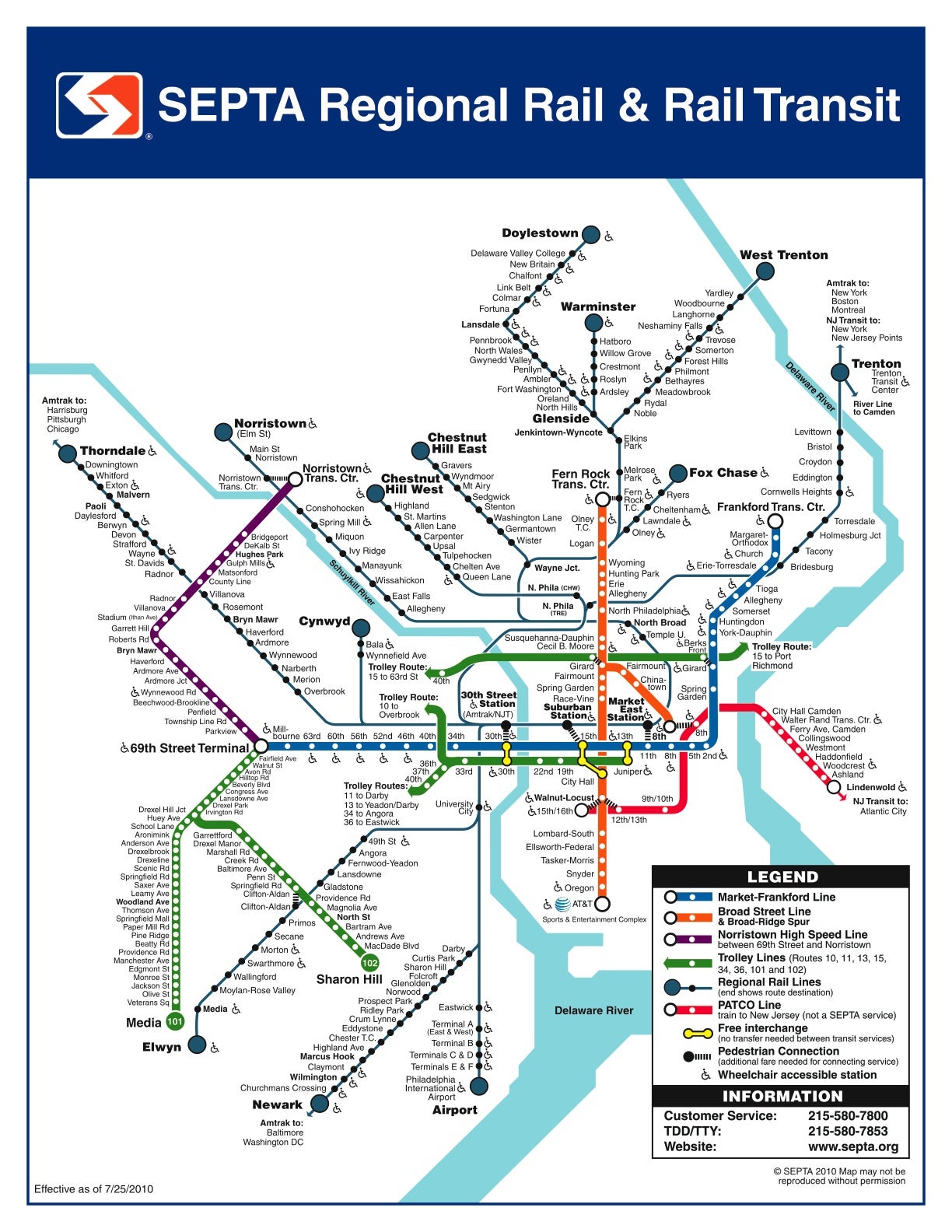
But despite some changes in service, SEPTA is still using a map similar to the version it produced after taking over regional rail from the Pennsylvania and Reading railroads in the early 1980s.
So, a few years ago, Center City graphic designer Joel Katz thought it was time to rethink that map.
While working on the recent sign project for the Center City transit concourse ― he’s responsible for the green “S” leading to stations and for the underground concourse maps ― Katz took it upon himself to draw a new map for SEPTA.
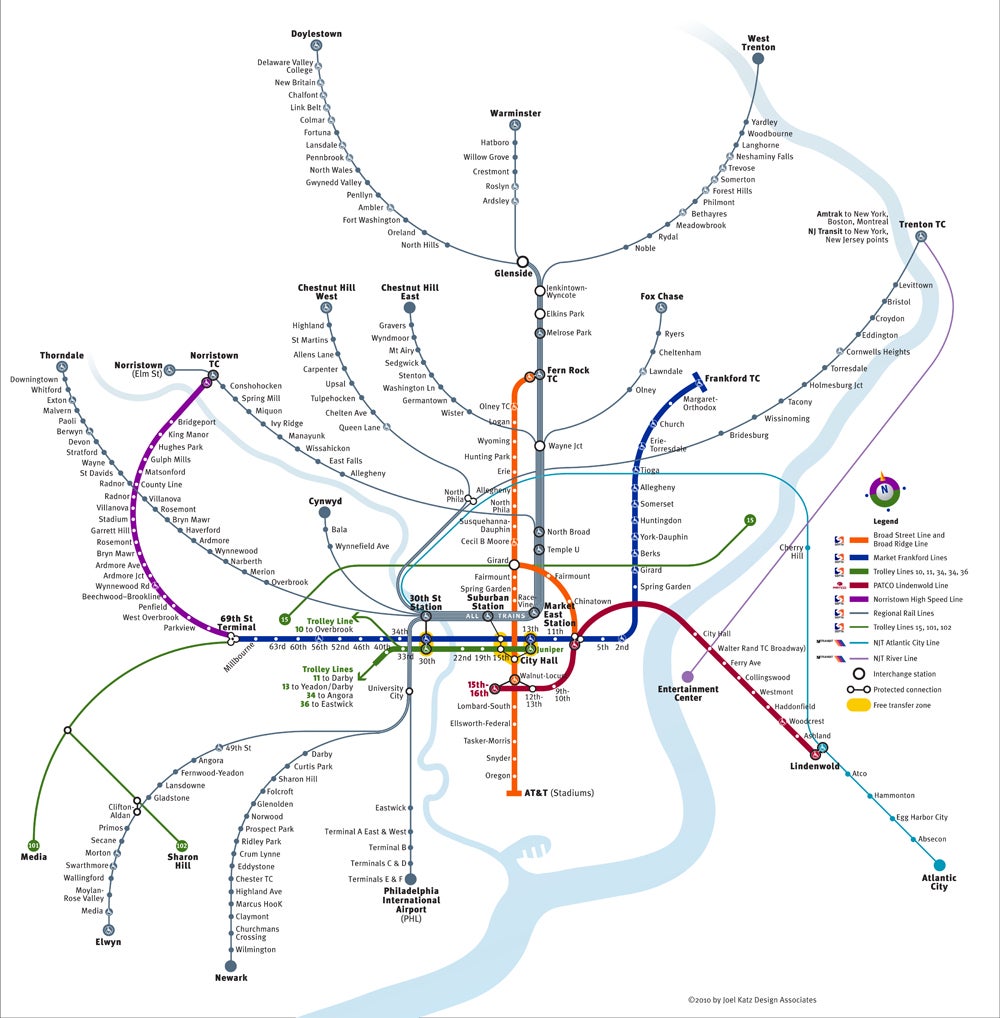
The result was a design that represents a radical departure from SEPTA’s current incarnation, which uses 45-degree angles to represent the different modes of transit. Instead, Katz’s lines curve gently outward from Center City.
And instead of depicting the geographically correct long loop trains take around Center City — as does SEPTA’s version — Katz’s map sketches out a big trunk going up to places like Jenkintown in order to make it easier to read.
The point, Katz said, is to clearly show the order of stations for riders ― not to represent the actual trackage trains take. Geography, in this case, is “counter-indicated.”
Along that same vein, riders can see, at a glance, how many regional rail lines serve a given station because each rail line gets its own, distinct line on the map.
Katz updated the map at PlanPhilly’s request to include the River and Atlantic City lines in New Jersey. It now also avoids reference to the now-jettisoned regional rail line numbers and colors.
Katz’s map drew praise from Penn Praxis executive director Harris Steinberg, who said Katz showed him the idea several years ago. “I think it’s very elegant and legible and has a wealth of information on it that really makes the system intelligible,” he said. “I think it’s a good map.”
He praised the map for being more geographically consistent in representing the Delaware and Schuylkill Rivers than SEPTA’s version and for drawing clear distinctions between the different modes of transit SEPTA runs. “It would be great if something like this were adopted,” Steinberg added.
Paul Levy, president and CEO of the Center City District, which spearheaded the concourse project, also praised Katz’s map.
Levy, who has known Katz for years ― he also designed the CCD’s logo and the pedestrian disc maps in Center City ― called this map Katz’s “passion.”
He added that Katz’s effort has a “playful element about it” with its curved lines. At the same time, Levy said, “your mind can grasp it pretty quickly,” even if you’re an out-of-towner.
At Katz’s request, Levy said he passed the map along to SEPTA back in 2007, though he never actively advocated for it and said SEPTA may have good reasons for not adopting it.
Katz, for his part, said he’d provide the map to the authority at a steep discount. That won’t be happening anytime soon.
Kim Scott Heinle, SEPTA’s assistant general manager for customer service, said he thought the map looked nice but didn’t see a point in replacing the current version. “It’s nice, but I like ours,” he said, explaining that it would be a labor- and capital-intensive project to replace SEPTA’s map with another version.
Major map redesigns, he said, usually cost transit systems “millions and millions of dollars” ― something the authority doesn’t have right now.
To save money, the map’s recent redesign ― in which the regional rail numbers were eliminated ― was done in-house, Heinle said. “Why would we change it just to change it?” he asked, adding that riders are comfortable with the current one.
On some level, he and communications director Elizabeth Mintz, who was in charge of the latest map redesign, think designing a new system map misses the point. Since more and more people get their information from the Internet, they argued SEPTA should better focus its efforts on increasing and updating its Web presence.
Mintz said the Internet gives SEPTA the opportunity to provide more information to riders than they could find on a station map. The site already includes fare, bike and car parking information, and she’s working to add things like alternate service information.
So while riders won’t be seeing Katz’s map plastered in their local train station, Heinle said they’ll be able to see the real-time location of buses as they travel their loops. A Beta version of the BusView system, covering two routes, is running now. He said BusView should be expanded to all routes by the end of the year.
Contact the reporter at acampisi@planphilly.com
WHYY is your source for fact-based, in-depth journalism and information. As a nonprofit organization, we rely on financial support from readers like you. Please give today.


