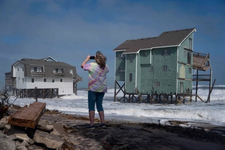
Jersey Shore braces for potentially highest water levels in decade as nor’easter delivers final blow
People across the Philadelphia area are dealing with wet and windy conditions from the coastal storm.

A person stands and takes photos of houses at risk of collapse in the midst of a storm, Sunday, Oct. 12, 2025, in Buxton, N.C. (AP Photo/Allison Joyce)
This story originally appeared on 6abc.
Major coastal flooding and wind-whipped rain will hit the mid-Atlantic and Northeast coastline Monday as an impactful nor’easter crawls up the East Coast for a third consecutive day.
The storm has already disrupted air travel at major Northeast airports, triggered serious flooding in South Carolina and threatens to push the ocean into homes and onto roads along the mid-Atlantic coast at Monday afternoon’s high tide.
This coastal storm is called a nor’easter due to the prevailing wind direction from the northeast ahead of its center. These northeast winds push water toward the coast, causing it to erode beaches and pile up and cause flooding.
People across the Philadelphia area are dealing with wet and windy conditions from the coastal storm. However, impact from the storm is mostly being felt along the coastline, bringing gusts up to 60 miles per hour and prompting road closures.
People waking up Monday to head to work should be cautious of both wind and flooding if you’re driving.
Remember to not drive through flood waters, and watch for downed trees and power lines.
Water levels Monday afternoon could reach a mark not touched in more than a decade along the Jersey Shore.
“Widespread roadway flooding and closed roads, damage to structures and evacuations are possible,” the National Weather Service warned.
⚠️🌊 Here is the latest coastal flood threat for the high tide this afternoon/evening. The strongest winds have already occurred, but some gusts near 30-40 mph will remain possible area-wide today. #NJwx #DEwx
— NWS Mount Holly (@NWS_MountHolly) October 13, 2025
Latest briefing here: https://t.co/JiD09ByGTv pic.twitter.com/PFRdt0nAmR
Acting New Jersey Gov. Tahesha Way declared a state of emergency that went into effect Saturday night “out of an abundance of caution,” asking residents to stay off the roads “unless absolutely necessary.”
Water levels climbed into minor flood stage on Sunday afternoon in Atlantic City, New Jersey, and shut down Route 40 and Route 30 in both directions in and out of the city. The flood threat will climb even higher to above 8 feet Monday, which would be the highest level observed since Superstorm Sandy in 2012.
Atlantic City had been getting ready for the storm over the last week, Mayor Marty Small Sr. told CNN on Sunday, adding the city had learned from past storms like Sandy how best to prepare.
“We always prepare for the worst and keep hoping for the best,” the city’s Acting Emergency Management Coordinator Michael Famularo told CNN.
Barnegat Bay and Great Egg Harbor Bay along the Jersey Shore could also hit major flood stage this afternoon. Widespread road flooding and damage to structures are possible at that level, the National Weather Service says.
A whole section of road on Route 322 in Egg Harbor Township is closed to traffic due to flooding.
Levels at Cape May, New Jersey, are projected to reach over 8 feet on Monday and would be the third-highest on record and the highest since January 2016.
“We saw really bad flooding earlier [Sunday], like the beach was all the way up to the beginning of the walkway there,” said Andy Chermela, from Lafayette Hill.
“The wind is so strong,” said Scott Hartranft of Somers Point. “I’ve been down here many a times before but never this strong.”
Some New Jersey Transit bus and rail services are also suspended through Monday, the service said, citing safety concerns from the storm.
New video shows floodwaters taking over streets at the Jersey Shore.
The storm’s force could be felt along the boardwalk, where debris was scattered and waves crashed against the shore.
The Delaware Emergency Management Agency activated the state National Guard to help with any storm-related issues, DEMA announced in a news release Sunday. A voluntary evacuation order was issued for the town of Bowers Beach, where the Murderkill River flows into Delaware Bay.
When will it end?
Strong winds gusting up to 45 mph will continue to lash the coast as the storm crawls north through Monday. Some of the strongest gusts through Monday afternoon are expected from New Jersey into southern New England.
These wind gusts are as strong as what a tropical storm produces, despite this storm not being classified as one.
Winds should begin to subside Monday night into Tuesday as the storm pulls away from the coast.
Some of the storm’s heaviest rain has already soaked the Carolinas, but the Northeast will continue to see showers Monday.
The nor’easter will finally pull away from the coast Tuesday. High pressure will build in behind the storm, resulting in dry weather and decreasing winds.
Around 12,000 customers in New Jersey are without power early Monday, according to Poweroutage.us.
Travel Impacts
Rainfall and gusty winds could cause more delays at Northeast airports Monday.
The storm caused long delays and ground delays at times Sunday at Boston Logan, New York’s John F. Kennedy, Washington, DC, Reagan National, Newark Liberty, and Philadelphia airports, according to the Federal Aviation Administration.
Thousands of flights were delayed nationwide Sunday.
CNN contributed to this report.
WHYY is your source for fact-based, in-depth journalism and information. As a nonprofit organization, we rely on financial support from readers like you. Please give today.


