Modern-day maps are cool, too
Listen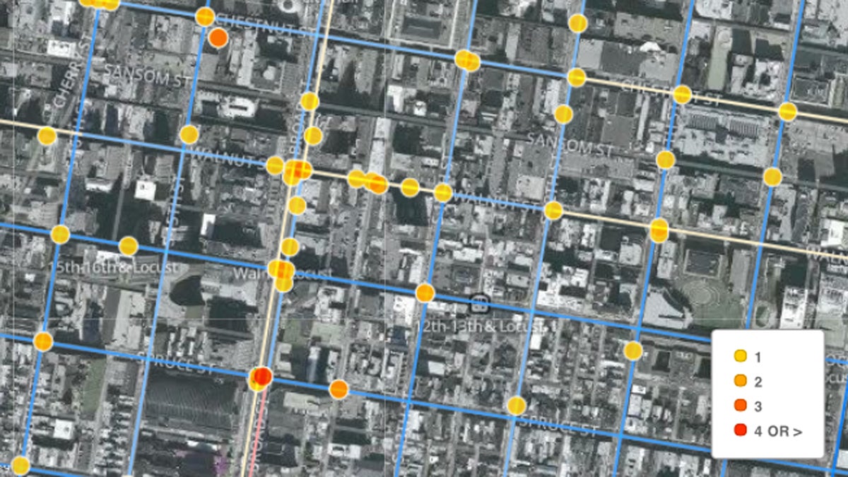
This map, created under Azavea's "Summer of Maps" program, shows the locations of reported bike crashes in Philadelphia between 2007 and 2012. (Image courtesy of Azavea)
Mapping is having a moment. Credit the visual nature of the Web. Credit the nagging persistence of human curiosity. Maps are cool.
“Maps are a universal language,” said Sarah Cordivano, a project manager at the Philadelphia-based mapping firm Azavea. “You don’t have to understand a complicated software product or Excel to look at a map. It’s easy, it’s simple and it communicates very nicely.”
Azavea does mapping work for nonprofits and companies both here in the Philadelphia region and across the country. It also does a program called Summer of Maps, where young geographers complete fellowships that deliver high-quality mapping work to nonprofits.
For this week’s episode of The Pulse, Maiken Scott gathered sound from the most dangerous intersection in Philadelphia for bicycling. We knew where to send her — the intersection of Broad and Spruce Streets — because of this map from last summer’s Summer of Maps.
The program also yielded a map on food insecurity in the Philly region, as well as others on early childhood education. (Applications recently opened for Summer of Maps 2014.)
But mapping health can be tricky.
Good data underlie good maps, Cordivano says. And health data tend to be guarded. For her master’s thesis, Cordivano mapped the impact of maternity ward closures in the Philly region. She says she could only access that data because of her university affiliation — a limiting factor for outside groups and researchers.
Of course, there are some people mapping health in inventive ways.
Last week, WHYY’s Elana Gordon reported on a new initiative in Camden spearheaded by a certified “genius.”
“We’re picturing this to be a little like the weather report,” said Jeffrey Brenner, a recent winner of a MacArthur award and the executive director of the Camden Coalition of Healthcare Providers. “The public should know how much they’re spending on health care, and how much necessary and unnecessary care is being delivered in Camden.”
The $450,000 grant from the John S. and James L. Knight Foundation is going toward mapping real-time health data in Camden. It will fund a partnership between Brenner’s group and a firm called BlueLabs, whose founders did highly sophisticated data work for the Obama election campaign.
Brenner says the goal is to make health data — on everything from emergency room visits to diabetes-related foot amputations — engaging, visually.
“We’re a big believer in the democratization of data,” Brenner said. “We can’t change large broken systems if people don’t understand how broken they are.”
Mapping is a means to that end. If you can communicate data more effectively, maybe you can deliver health care more efficiently.
WHYY is your source for fact-based, in-depth journalism and information. As a nonprofit organization, we rely on financial support from readers like you. Please give today.
