Improving access in the Lower Schuylkill Innovation District

Much of the Lower Schuylkill is an impenetrable, legacy industrial landscape, and good access is one problem holding back its tremendous potential.
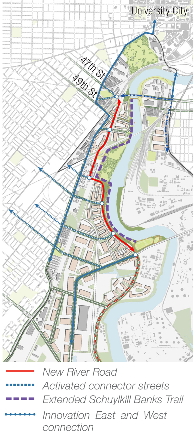
But the Lower Schuylkill has been lavished with planning attention in the last two years and now, the Philadelphia Industrial Development Corporation (PIDC) is looking to make the area easier to navigate by creating a new north-south “river road.” This new road, an early action project identified in the Lower Schuylkill Master Plan released last year, would run along the eastern side of the river, between the Grays Ferry and Passyunk Avenue bridges in the “Innovation District” (See map below.)
Seven firms responded to PIDC’s recent request for proposals to help figure out the optimal alignment for the new river road, and how other streets intersect will with it. Results of this study are expected late this year. After that PIDC will be able have more detailed conversations about actual road building and transportation service with its government partners and SEPTA.
A new road may seem like no big deal, but circulation and riverfront access are terrible in the Lower Schuylkill. As the RFP notes, “These deficiencies contribute to the lack of redevelopment and investment in this area.”
Huge industrial properties often mean east-west streets simply dead end or are closed off as they near the river, and active rail lines make the area hard to cross. The addition of a new road between the railroad tracks and the river would open up the Innovation District, the area of the Lower Schuylkill closest to University City which is seen as likely to redevelop quickest.
As PlanPhilly previously reported, the river road concept received some pushback from neighbors because some feared such a road would actually cut off public access to the waterfront.
“One of our goals is to improve public access to the river,” said PIDC’s Kate McNamara. She notes that the new road will primarily be a north-south connector, but there will also be improvements made to the east-west streets, which are the primary ways that neighbors will approach the river and future sections of the Schuylkill Banks Trail.
In terms of street design, the river road will be a complete street, with pedestrian and bicycle infrastructure. Imagine the street like Lindbergh Boulevard, but with features seen on the 58th Street Greenway, not Kelly Drive and not Columbus Boulevard.
“The goal is to incorporate pedestrian and bicycle amenities as frequently as possible. So we’ll look at that as part of the next phase,” said McNamara. The same goes for new transportation service.
WHYY is your source for fact-based, in-depth journalism and information. As a nonprofit organization, we rely on financial support from readers like you. Please give today.


