New Jersey under state of emergency as Erin brings flood warnings to Jersey Shore and Delaware coast
The storm is heading away from the Mid-Atlantic coast, but is bringing high winds, big waves and coastal flooding.

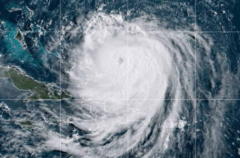
This image provided by the National Oceanic and Atmospheric Administration (NOAA) shows Hurricane Erin on Monday, Aug. 18, 2025. (NOAA via AP)
From Camden and Cherry Hill to Trenton and the Jersey Shore, what about life in New Jersey do you want WHYY News to cover? Let us know.
New Jersey is under a state of emergency Thursday to prepare for Hurricane Erin.
The storm is moving away from the Mid-Atlantic coast and is not expected to make landfall. But it is forecast to cause flooding near shorelines and tidal waterways in Delaware and New Jersey.
As of 2 p.m. Thursday, the storm had already brought wind gusts of up to 45 miles per hour and offshore waves of up to 14 feet along the New Jersey and Delaware coasts, according to the National Weather Service. Forecasters are warning of “life-threatening” surf conditions.
Gov. Phil Murphy declared a state of emergency across New Jersey starting at 2 p.m. Thursday. Murphy warned of winds of up to 50 mph in parts of the state, and waves breaking as high as 17 feet along the shore.
“Over the past couple of days, we have seen the effects of Hurricane Erin along the Jersey Shore in the form of dangerous rip tides. Today and tomorrow will be no exception,” Murphy said in a statement. “As the storm moves past New Jersey over the next 24 hours, we are expecting high surf and rip currents, coastal and flash flooding, and a high erosion risk in parts of the state.”
Murphy asked residents to stay aware of local weather forecasts and evacuation protocols and routes, in case of emergencies. Maps of New Jersey’s coastal evacuation routes can be found on the state’s website. The governor also urged residents to move cars from flood-prone streets.
The National Weather Service said flooding is expected to peak Thursday evening with the high tide, which arrives around 7 p.m. in Long Branch, New Jersey; 8 p.m. in Cape May, New Jersey, and Lewes, Delaware; and 11 p.m. in Toms River, New Jersey.
Some low-lying places could see 3 feet of flooding, according to the National Weather Service.
Widespread “minor to moderate” coastal flooding could continue with the high tides through Friday evening along the New Jersey and Delaware coasts, Delaware Bay and tidal portion of the Delaware River, forecasters predict.
Forecasters predict the worst flooding will be in Cape May County, New Jersey, and Sussex County, Delaware.
Floodwaters could damage structures and inundate roadways, possibly isolating some areas, according to the National Weather Service.

Get daily updates from WHYY News!
WHYY is your source for fact-based, in-depth journalism and information. As a nonprofit organization, we rely on financial support from readers like you. Please give today.


