FixPhillyDistricts – Mapping a path to better democracy
The Philadelphia City Council plans to approve its new election map soon after Labor Day, with scant public input. So three civic partners, with the help of WHYY, invited Philadelphians to draw a better election map for their city council. The results are likely better than what Council will propose.
The Philadelphia City Council plans to approve its new election map soon after Labor Day, with scant public input. So WHYY partnered with Azavea Inc., The Daily News, and the Penn Project for Civic Engagement to invite Philadelphians to draw a better election map for their city council. This is the result.
August is a month of diversions. People get sun at the shore, seek peace in the mountains. They cheer the sizzling Phillies, and dream on the high-spending Eagles.
This August mixed in some added distractions.
The earth shimmied, and Arlene Ackerman jimmied nearly a million bucks out of the Philly schools. Irene unleashed a flood of waters – and tweets.
Sounds like an inopportune time, doesn’t it, to invite corruption-weary citizens of Philadelphia to hunch over their laptops, tackling the arcane task of drawing a better election map for their city?
So, of course, that’s just what I and a couple of my frequent partners in civic do-gooding decided to do. They were: Robert Cheetham of Azavea Inc., the hip mapping firm in town; Sandy Shea, editorial page editor of the Daily News; and Harris Sokoloff of the Penn Project for Civic Engagement.
Azavea set up a Web site called FixPhillyDistricts.com to make its cool election mapping software available and usable by anyone. NewsWorks/WHYY offered prizes for the best new Council district maps drawn using Azavea’s tool. PPCE helped people think about the values they should embed in their maps, and Sandy made sure Council people knew what was going on and urged them to pay attention.
Why do this in the middle of distracted August?
Because City Council plans to approve its new election map soon after Labor Day, with scant public input. (The City Charter imposes the deadline, but the half-hearted public process is all Council’s fault.) Time to generate at least some form of civic imagination around this critical process was short.
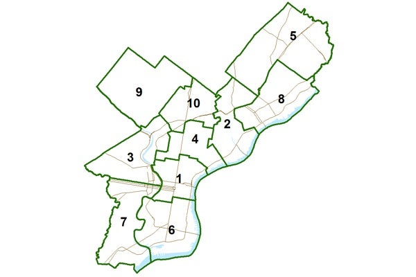
Now, Council could not possibly inflict a worse map on the city than the jagged monstrosity (see slideshow above) it produced after the 2000 census. (An earlier Azavea study tabbed the Seventh Council District as one of the most gerrymandered electoral districts in the nation.)
Not worse, maybe, but possibly still pretty bad.
So, before Council members do whatever it is they are going to do in pursuit of their self-interest, we wanted to hold up to public light a few examples of sane maps that reflect real community interests.
Did we get any?
Even during August, yep, we did. More than 1,200 maps were started on FixPhillyDistricts.com by more than 400 people. Some people and teams did many maps before submitting to the contest the one they liked best.
The contest reaped 70 fully valid maps, meeting all legal and contest standards. (See slideshow.) Maps came in from as far away as Boston, Dallas and Erie. The guy from Erie said the exercise helped him stay sane while recuperating from surgery. (Glad to help, sir.)
I will state this boldly: Every last, single, blinking one of the citizen maps is far superior to the current mess, and likely better than what Council in the end will propose.
In the notes people filed with their plans, you can see them struggling with the tensions among various legitimate goals.
Balance population precisely, and it’s hard to avoid those jagged lines that one person said make a district look “like an electrocardiogram.”
Try to preserve natural neighborhood boundaries and it becomes hard to balance population, particularly given the growth spurt over the last 10 years in Northeast Philadelphia. That one confounded a lot of map-makers.
Some people worked hard to create a majority Hispanic district; others scorned that goal. Some people seemed to want to mix areas of differing economic status in a district; others lumped like with like.
People from Center City tended to make a first principle of creating a Council District to cover just that area – with maybe University City or Northern Liberties thrown in. People from outlying areas were much more likely to split Center City up, often at Broad Street.
It was interesting to me to see how many people used rivers and creeks as a guide to creating districts, assuming that even in our day, water spawns a meaningful community of interest.
Almost no one who did a map gave a hoot where incumbent Council people lived, or how the new district lines would affect their re-election chances.
In sum, people did work through the tensions, to achieve maps that were all sensible, and in some cases elegant.
And they approached the task very thoughtfully, as their explanatory notes show.
On Tuesday, right here on NewsWorks, we’ll present the winners: one overall winner, a couple of honorable mentions, and winners for three sub-categories: compactness; equal population among districts, and least splitting of political wards among districts.
We’ll also present the winners to Council members at a hearing on redistricting scheduled for 7 p.m Tuesday at Einstein Medical Center in North Philly.
Bottom line of this uphill August experiment: Citizen-driven democracy can work – and be a little fun to boot.
Remember to check back here Tuesday to see the winning maps. Follow me on Twitter @Chrissatullo.
WHYY is your source for fact-based, in-depth journalism and information. As a nonprofit organization, we rely on financial support from readers like you. Please give today.


