FAQ: 5 things to know about weather forecasts and climate change
Climate change means more extreme weather across the U.S. That’s a challenge for weather forecasters.
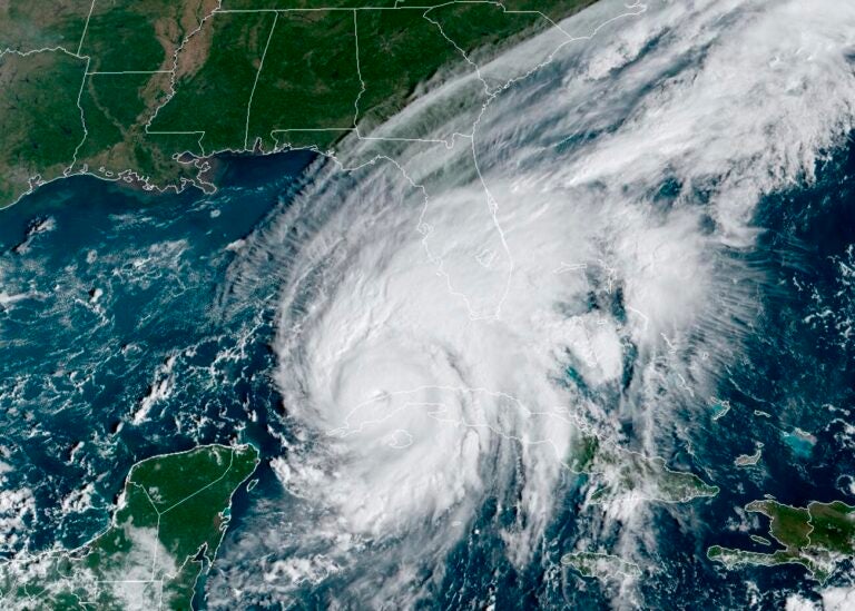
Hurricane Ian passes over western Cuba in 2022, as captured by a U.S. weather satellite. Climate change is causing more extreme weather, and creates new challenges for weather forecasters. (AP/NOAA)
Climate change is causing the weather to get more erratic across the U.S. Rain storms that used to happen once in a lifetime now occur every few years. Heat waves are hotter, and last longer. Hurricanes come ashore with more powerful winds and storm surge.
Federal weather forecasters are on the front lines. Virtually everyone in the United States relies on forecasts from the National Weather Service, which inform everything from the weather you see on the nightly news to the weather app on your phone. And, when extreme weather is headed your way, it is the weather service that issues warnings.
“Climate change is increasing the frequency of these big events, and increasing the intensity of these events,” says Ken Graham, the director of the National Weather Service. “It’s tricky.”
Here are five things to know about how climate change is affecting weather forecasts, and what you can do to protect yourself from extreme weather.
1. Climate change makes it trickier to forecast the weather
Climate change makes it more difficult to predict the weather, because as the Earth heats up, it causes weather patterns to change and get more extreme.
Traditionally, weather forecasters relied on their understanding of past weather patterns – basically what “normal” weather looks like for a given place – to predict future weather conditions. But the future no longer looks like the past, Graham says.
“It’s interesting, you start looking at the data [and] 7 out of the last 10 Atlantic hurricane seasons were above normal,” says Graham, who previously ran the National Hurricane Center, which is one of multiple specialized forecast offices within the National Weather Service. Abnormally hot ocean water in the Atlantic and Caribbean has helped drive relentless hurricane activity in the last decade.
A similar pattern is playing out with floods, which are often caused by intense rainfall that’s getting more common as the Earth’s atmosphere warms and holds more moisture. The weather service sees this in real time, Graham says. “In 1985 we had about 30 flash flood events a month,” he says. “In 2020 we had 82 [flash floods], and we project 2025 to have 90 flash flood events. So if you think about it, it’s tripled since 1985.”
2. Weather forecasting technology has gotten a lot better in the last decade
The good news, weather forecasters say, is that the technology for predicting the weather has gotten a lot better in recent decades. That’s helping the weather service adapt, and keep up with the deluge of dangerous weather.
“It’s difficult to describe how much better [the technology] has gotten,” says Bill Bunting, the deputy director of the Storm Prediction Center in Norman, Okla. October will mark Bunting’s 39th year with the weather service. He says in that time, as the climate has changed, the tools for understanding the weather have also transformed.
“Doppler radar, satellites with updates every 30 to 60 seconds,” and computer models that allow forecasters to see into the future more accurately have made forecasts more accurate even as conditions have become more uncertain, he says.
3. The more local, the better, when it comes to warning people about extreme weather
Protecting people from more extreme weather means warning them when that weather is headed their way, and that requires hyper-local, specific weather forecasts, Bunting says.
“Throughout my career we’ve gotten steadily better at not just issuing warnings for counties or parishes or large cities, but being increasingly specific in space and time,” Bunting says.
Tornado forecasts are a good example, he says. While the connection between climate change and tornado frequency is still a topic of active research, what is clear is that there are more people than ever living in tornado-prone parts of the U.S. Protecting those populations from tornados requires forecasters to pinpoint exactly where tornadoes are forming, and then warn people as early as possible that their specific neighborhood is in the crosshairs.
The same is true for hurricane and flash-flood forecasts.
Weather service offices are local for this reason, says Graham. There are more than 100 offices spread out all over the country.
4. The National Weather Service has changed how it presents extreme weather forecasts in response to climate change
Changes in extreme weather have led the weather service to change some of the most basic tools it uses to communicate with the public.
In recent years, the National Hurricane Center has overhauled the maps and other graphics it uses to warn people about the hazards from hurricanes. Now, there are new storm surge warnings, new language about how quickly storms can intensify before hitting land and a new hurricane track forecast map that will roll out later this summer and will include warnings about flooding and other hazards.
In 2017, the weather service had to add new colors to its rainfall map for Hurricane Harvey, which dumped an unprecedented amount of rain in Texas. And a new color-coded heat warning system was introduced this spring to better warn people about dangerously hot weather.
Graham says the goal is to make it clear to the public that weather norms are changing, and they need to prepare for weather they might not have experienced in the past.
“I hear this all the time across the country: It’s never happened here before!” Graham says. “But that doesn’t count anymore.”
5. Warnings are only useful if people heed them
As climate change supercharges the number of extreme weather events that hit the U.S. each year, one of the biggest challenges is to avoid a “crying wolf” phenomenon, where Americans begin to tune out what feel like constant weather warnings. “We call it warning fatigue,” Graham says.
Making warnings as local as possible is one solution. Rather than sending out a warning for an entire region, the weather service is working to narrow down who is most at risk from a given flood, hurricane, heat wave or other dangerous weather event, so they can target their warnings to the narrowest group possible.
But it’s impossible to narrow down such warnings completely: for any given disaster, there will always be people who were rightly warned of the danger, but luckily weren’t personally affected, Graham says.
The key, he says, is not to let such situations lull the public into complacency. “There really aren’t these false alarms that are perceived,” he says. “If you get a tornado warning and it happens 20 miles away, you may not see a lot.” But that doesn’t mean you weren’t at risk, or that the next tornado in your area won’t affect you, he stresses.

Get daily updates from WHYY News!
WHYY is your source for fact-based, in-depth journalism and information. As a nonprofit organization, we rely on financial support from readers like you. Please give today.

