Smoke on the water: Sea smoke returns in N.J.
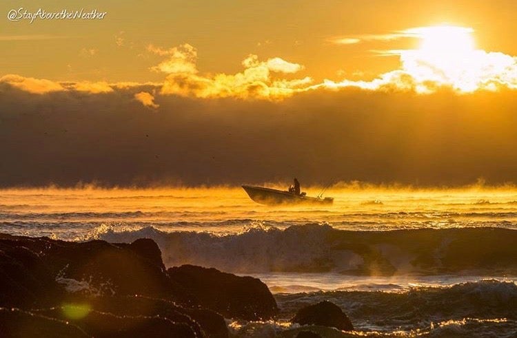
The early beach birds were greeted by a visually stunning scene on Saturday morning.

Matt Reitinger/Stay Above the Weather
The early beach birds were greeted by a visually stunning scene on Saturday morning.
In Long Beach Island, the ocean temperature at sunrise was in the middle 50s while the air temperature hovered around 20 degrees.
That’s where Matt Reitinger, publisher of Stay Above the Weather, captured a boater navigating through “sea smoke,” a phenomenon that only occurs during sharp air and water temperature differentials.
Delaware Sea Grant explains:
These smoky-looking plumes rising from the ocean surface can be seen when still cold air overruns the warm moist air at the sea surface. Because the surface air is so much warmer than the cold air above it, the moisture in the rising warm air quickly condenses into small water droplets (like seeing your breath on a cold day). This phenomenon is often observed in colder climates – for example in the Arctic, Antarctic, and along the coast of Maine. Autumn is the season when sea smoke is most typically observed, as cold blasts of polar air masses blow over warm Atlantic waters.
Further north, Laurie Glasser captured this scene in Spring Lake:
This is the earliest occurrence of sea smoke since WHYY began reporting on the phenomenon in 2014.
So if you’re looking for warmth, go surfing.
WHYY is your source for fact-based, in-depth journalism and information. As a nonprofit organization, we rely on financial support from readers like you. Please give today.


