

Why engineers use different barriers to protect N.J. coastal towns
If you live along the Jersey Shore, you may notice a variety of barriers in place to prevent flooding. Here's a look at a few of the most common techniques.

Sandbags are used to slow the erosion of the bank along the Delaware River. (Bill Barlow for WHYY)
New Jersey’s East Point Lighthouse at the mouth of the Maurice River has survived pelting winds, driving storms and long periods of neglect in its 170 years.
Before the end of this year, a state project could help protect the historic building on the Delaware Bay from eroding land and rising seas.
The state plans to install 900 feet of Geotube, made of flexible material filled with sand, to protect the lighthouse and its sandy bayfront parking lot from tide-driven floods.
The bids will go out soon, with the work to begin in late summer, said Larry Hajna, a Department of Environmental Protection spokesman. That will avoid interference with breeding horseshoe crabs or the migrating birds that depend on their eggs. Once completed, the Geotube will be covered with sand to resemble a dune, Hajna said.
“Basically, it’s a big Christmas stocking which you stuff full of sand,” said Stewart Farrell, the director and founder of the Coastal Research Center at Stockton University in Pomona.
But what’s right for the Delaware Bay may not always be what’s right for a town facing the ocean.
“The East Point Lighthouse is in an entirely different environment than, say, Atlantic City’s Boardwalk,” Farrell said. “What would be fine for the lighthouse would be a complete waste of money out on the oceanfront. Are you trying to stop a runaway freight train? Or are you trying to stop a kid on a bicycle?”
Several factors determine waves. The strength of wind blowing across the water and the area of water surface over which that wind blows — known as fetch. It’s a little over 22 miles across the Delaware Bay from the lighthouse to the small town of Bowers, Delaware.
“In the Delaware Bay, the fetch is limited,” Farrell said. “And so there’s a very finite wave size that you will see, no matter what kind of storm you have. That means the fabric material to be put in place will likely work fine. You’re not going to see 15-foot breakers.”
Engineers have to determine the best way to protect the coastlines — and that means using different barriers to get the job done. Here are a few approaches that you may have seen used in New Jersey.
Geotubes
Geotube, a brand name for a kind of long sandbag, was trademarked by the Netherlands in 1994. Farrell uses the more generic name of geotextiles. Sand and water are pumped into a large synthetic fabric sleeve. The water drains off, leaving the sand contained.
“The sand doesn’t move away so readily. But it’s not such a hard structure that it can’t be removed. You can cut the thing open and pull the fabric away,” leaving the sand in place, Farrell said. They can range from 3 feet wide by 12 feet long to hundreds of feet long and 10 to 12 feet wide.
“The biggest one I’ve seen put in place in New Jersey was in Sea Isle City,” he said. That one was about 2,400 feet long.
Sunlight is a weakness for this style of shore protection, he said. Manufacturers continue to improve the product, but UV rays can break down the fabric over time. Often, Geotubes are covered in sand, both as protection and to make them look more like dunes.
That’s the DEP’s plan at the East Point Lighthouse, and what was done along Ocean Drive in northern Sea Isle City and southern Strathmere. A portion of the Geotube was exposed there after Hurricane Sandy but was reburied as part of a beach replenishment since then.
Sand replenishment

When sand disappears from beaches, the obvious solution is to put it back. The process has been going on for decades, even before the Army Corps of Engineers began a 50-year commitment to protect Cape May’s beaches in 1991.
That set the standard for future projects. From Seaside Heights to Avalon, and for most of New Jersey’s beach towns, a huge dredge pumping sand from offshore to rebuild eroded beaches has become a routine sight.
Even before Hurricane Sandy brought a flurry of federal spending to beaches, the cost of beach replenishment in New Jersey had topped $1 billion, with no end in sight.
Farrell said there is little choice in the matter.
“If you want to have a recreational facility, you’re kind of limited to beach fills,” he said. “In other words, you bring in material and replace it as it moves elsewhere, or bring it back from where it moves to.”
The replenished beach will protect properties from future storms and keep the summer visitors happy.
Farrell said the sand moves in predictable ways.
“After a beach fill, that sand doesn’t melt,” he said. “It goes somewhere else.”
Aside from pumping sand in from the inlets offshore, he said, towns could also gather the sand that washed to other areas and return it to the eroded section. He said the next step is to get approvals from regulators. But he predicts resistance.
“It will require some convincing of the folks in that area. They say, ‘You’re not taking my sand.’ Well, first of all, it’s not your sand,” he said.
For instance, North Wildwood’s beaches are extensively eroded, while the beaches in Wildwood and Wildwood Crest to the south on the same barrier island have grown over 20 years, he said.
“It’s real cheap compared to pumping material from offshore,” he said.
The Army Corps of Engineers has made dunes a key component of beach projects. The dunes can block storm-driven waves and serve as a reserve of sand as the ocean removes beach. There has been controversy there, too, with Margate opposing the construction of dunes as part of a 2017 beach project.
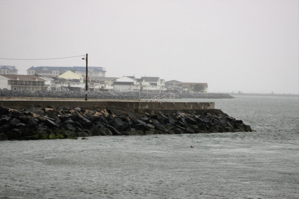
Jetties and groins
Hard structures of timber or rock that run perpendicular to the beach have been used for more than a century. They were put in place around the Atlantic City Lighthouse in the 1860s, Farrell said.

“It was the first place I know where they were happy with the success of building them,” he said. “The engineers figured if it worked there, it can work everywhere, which of course it didn’t.”
The structure interrupts the flow of sand down the beach, with the idea of slowing erosion. They are common along the coast. Some areas have stone jetties every few blocks.
“Anything that’s perpendicular to the shoreline serves to restrict the movement of material parallel to the shoreline. That’s the whole point of them,” Farrell said. “So the sand piles up on the side that’s facing the current and disappears from the side that faces the direction the current is going.”
That leaves a crescent-shaped beach, with more intense erosion on one side of the structure and sand gathered on the other side. That effect is clearly visible in aerial photos of the shoreline.
And jetties only change how the sand moves, Farrell said.
“So did it slow down the rate of movement? Yeah. But it didn’t stop the erosion at all. It’s still going on, it just has a different pattern to it,” he said.
In New Jersey, the terms “jetty” and “groin” seem to be used almost interchangeably. The website beachapedia.org clarified that jetties are the larger structures on either side of an inlet while groins are built to trap sand along beaches. Shore residents seem to use the opposite definitions, often referring to the long structures at the mouth of inlets as groins.
Hundreds of the structures were installed over the 20th century. A long barrier protects the Cape May Inlet between the Wildwoods and Cape May, helping grow the beach on the Wildwood side.
Seawalls
As construction techniques improved, seawalls became more common along the Shore, with several installed after a monster 1962 storm. Rather than jutting at a right angle to the beach, the seawalls run parallel along the Shore. These defend the most valuable property, Farrell said.
“It’s kind of like your final defense. It’s the Maginot Line,” he said, a World War II reference to the purportedly impenetrable defenses along the French border in the 1930s. But didn’t the Maginot Line fail? Well, so do seawalls at times.
“The water came over the seawall during Sandy in Seabright. Thousands and thousands of gallons of water crashing over the top. And the wall’s 26 feet in elevation,” he said.
The structures can speed the process of erosion, as waves slam into the barrier and wash back.
The beachfront promenades in Sea Isle City and Cape May were built as seawalls after the 1962 storm. There, and along the bulkheads in many other towns, the wall is an additional layer of protection behind the beach and dunes. In North Wildwood, the seawall along Hereford Inlet attracts walkers and joggers, but there is no beach along a long portion of the wall.
“You end up with a very narrow beach or none at all,” Farrell said, sometimes with water washing against the wall. “That’s great for bass fishing but not so much for beach going.”
There are other forms of barriers. Timber and steel bulkheads line many bayfront communities and serve as the dividing line of many beaches. Some towns, including Strathmere, are considering installing berms, or earthen barriers, to keep water from washing across flat marshland and into towns.
Pumping stations
Ocean City has spent millions installing pumping stations in recent years. The pumps move rainwater off city streets even if the tide is up above the level of the outfall pipe. Towns that Farrell works with have either installed pumps or are considering it.
Since Roman times and before, drainage systems have relied on gravity. But if the water level outside the bulkhead is higher than the flooding in the street, gravity will not move the water. Shore residents get used to waiting for the low tide for the streets to drain, but pumping it out is a lot faster.
“If it rains 2 inches in an hour, the pumps aren’t going to get ahead of that. But they’ll get ahead a whole lot faster than waiting for gravity,” he said. If a storm surge gets above the top of the bulkhead, however, no pump will keep water out of the town.
Other options include installing seagates at the mouth of inlets to keep high water from reaching back bays. That would cost billions of dollars at least, but hard choices are coming, Farrell said.
“What is rateable value of the overall coastal development? We’re talking about multibillions of dollars of real estate,” he said.
New Orleans and the Netherlands, where the land is lower than the water level, rely on tall levees and pumps to keep streets dry.
Some areas of the barrier islands, especially on the ocean side where the dunes have built up, are above the expected rising seas. But much of the infrastructure and property are below the level the seas are expected to rise, maybe not in this generation but in generations to come.
“So what are your choices? You either dike the whole thing so that no water ever gets in and you pump all of the rainwater out; you raise the ground 10 feet everywhere, utilities, roads, houses, all of it; or you walk away,” said Farrell. “Three choices.”
WHYY is your source for fact-based, in-depth journalism and information. As a nonprofit organization, we rely on financial support from readers like you. Please give today.
Part of the series
Watershed
Preserving Our Water: How we use our Delaware Watershed.
The project is funded by The William Penn Foundation.

Toxic ‘forever chemicals’ in New Jersey’s tap water have dropped 55%, Rutgers study finds
PFAS are commonly found in household items and can remain in the environment — and our blood — for decades.
4 weeks ago
Listen 1:19
A dead whale found on the bow of a ship in South Jersey sparks an investigation
The whale was found Sunday on a ship at the Gloucester Marine Terminal, which is at the base of the Walt Whitman Bridge.
4 months ago

New Jersey is investing $11 million to restore salt marshes, including Scotch Bonnet Island
Rising seas are drowning New Jersey wetlands. A new round of state climate funding aims to make them more resilient.
4 months ago
