Environmentalists: NJ’s coastal towns at risk of promoting development in flood zones

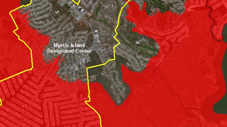
The area within the yellow line is a special economic zone. (Image courtesy of NJ Future's website)
New Jersey’s coastal towns are in greater danger of putting development in places where it will be flooded by rising seas or battered by future storms because of a new regulation that allows them extra time to build in areas that are eligible for state assistance, environmental groups say.
The New Jersey State Planning Commission on Wednesday unanimously approved a plan that gives municipalities throughout the state three more years to pursue economic development programs in areas that have so-called “center designations” — locations where proposed development would qualify for state assistance such as funding from the Economic Development Authority.
Environmentalists such as New Jersey Future accept the three-year extension for inland towns, but say the state should not be aiding development in coastal areas until their vulnerability to future storms and sea-level rise has been properly assessed.
“Why should the state encourage growth when we know it’s going to be in danger?” asked Chris Sturm, senior director of state policy for the nonprofit.
Sturm urged the commissioners to reduce the extension for coastal towns from three years to one, during which time the panel should help municipalities conduct risk assessments that include mapping areas that are likely to be flooded between now and 2050.
Without such assessments, coastal towns risk massive losses to property and danger to their residents, said New Jersey Future Executive Director Peter Kasabach.
“It’s understandable that towns want to preserve their center designations, with the attendant potential for more development and ratables, but to do so in coastal areas without requiring a robust risk assessment means those towns are just putting more people and property at risk,” he said in a statement.
According to a New Jersey Future study for Little Egg Harbor Township, based on sea-level-rise projections by Rutgers University, 31 percent of the township’s land area is likely to be inundated by 2050, and that 36 percent of the land would be flooded in the event of a Sandy-like storm that has a 1 percent chance of occurring in any given year.
The study also concluded that at a designated center on Mystic Island, which is part of the township, 52 percent of the land would be flooded in the event of a “1 percent” storm.
In a written response to New Jersey Future’s submission, the commissioners said that coastal towns are already planning for future development in light of the warnings of flooding related to climate change, and that the commission can change the areas that would qualify for state support if a municipality requests it.
“If a municipality voluntarily brings new information to the commission — an ability currently possessed by municipalities and one unaffected by these amendments — that alters the bases underlying the adopted map, the commission can make the needed alterations,” it said.
The extension of center designations — as contained in an amendment to the State Planning Act — is backed by Somerset and Morris Counties, the New Jersey County Planners Association, and the New Jersey Builders Association, which said the measure is of “critical importance” to its members who have used center designations as a guide to future development.
The NJBA argued in a statement that a failure to maintain center designations would curb economic development and delay the ongoing recovery from the recession.
Opponents of the extension argue that the cost of possible adjustments to center designations now would be insignificant compared with the cost of repairing inappropriately sited development after the next major storm.
Stacy McCormack, director of government affairs for the American Littoral Society, accused the commission of failing to alert coastal towns to their vulnerability to future flooding when making their development plans.
“I don’t think that local communities have a clear picture, especially in the coastal areas, of what they are facing right now,” she told NJ Spotlight.
She said issues such as water supply, climate change, and coastal vulnerability have not been included in the discussion over extending the center designations.
The commission is the appropriate forum to coordinate existing research on climate threats, such as the state’s hazard-mitigation plan that it submitted to the federal government as a condition for receiving FEMA funds, McCormack said.
“It’s not that it’s not out there, it’s that we need to bring it together to show a comprehensive map of New Jersey and where we’re headed in the future,” she said. “I don’t understand how you can do planning without any data.”
_____________________________________________________
NJ Spotlight, an independent online news service on issues critical to New Jersey, makes its in-depth reporting available to NewsWorks.
WHYY is your source for fact-based, in-depth journalism and information. As a nonprofit organization, we rely on financial support from readers like you. Please give today.


