Little to no snow accumulation Saturday night at the Shore

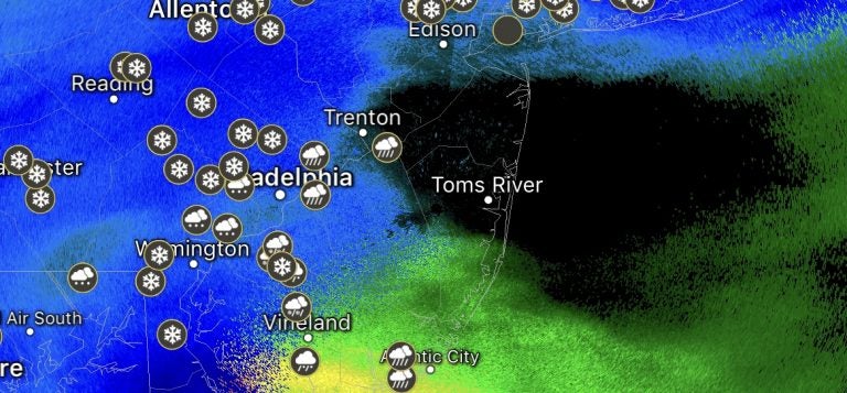
5:25 p.m. Saturday radar image.
It’s a snoozer of a snow event Saturday night into Sunday morning at the Jersey Shore as a low pressure system passes offshore.
At 5:15 p.m., snow extends from the Philadelphia area up through North Jersey, while rain is falling in Atlantic and Cape May counties.
The National Weather Service is forecasting around three inches of snow in western Monmouth County and northwestern Ocean County, one to two inches in the remainder of Monmouth County, less than an inch in most of Ocean County, and no snow accumulations in Atlantic and Cape May counties.
Precipitation (both rain and snow) moving into the area now. Here is the latest snow forecast map. The latest briefing is here: https://t.co/mMnIx09i4S #pawx #njwx #dewx #mdwx pic.twitter.com/LzVBbUcR0B
— NWS Mount Holly (@NWS_MountHolly) February 17, 2018
As warm air moves in overnight, the National Weather Service envisions any snow mixing and then changing over to rain, limiting snowfall amounts. Any accumulations will be on colder and untreated surfaces.
The forecasters expect all precipitation to end by around two to three o’clock Sunday morning.
Although not a robust storm at the Shore, the National Weather Service says to exercise caution on the roads tonight as “even small snow accumulations can create slippery driving conditions,” adding that there is a risk of black ice forming around dawn Sunday as temperatures could fall to freezing or just below.
Any snow will quickly melt Sunday afternoon as temperatures rise well into the 40s.
WHYY is your source for fact-based, in-depth journalism and information. As a nonprofit organization, we rely on financial support from readers like you. Please give today.


