

Tropical Storm Warnings as Isaias moves toward our region
Drenching rain could bring flooding from the coasts as Tropical Storm Isaias moves into the Lehigh Valley region.
This story originally appeared on NBC10.
___
Drenching rain could bring flooding to our region from the coasts to the Lehigh Valley and places in between Tuesday as Tropical Storm Isaias moves into the region. A tropical storm warning is in effect for most of the Philadelphia region.
A FIRST ALERT will be in effect for our area all day Tuesday due to the stormy impact of Tropical Storm Isaias, which is expected to bring flash flooding, power outages and coastal flooding to our region. The First Alert kicks in at 7 p.m. Monday as thunderstorms are expected.
A Tropical Storm Warning was already in effect Monday for most of the area counties in Pennsylvania, New Jersey and Delaware, with the exception of Berks County and the Lehigh Valley. The risk of flash flooding, damaging wind and heavy downpours spreads to the entire region, including the northern and western suburbs.
“It is going to track right over our area,” NBC10 First Alert Weather meteorologist Glenn “Hurricane” Schwartz said while noting it doesn’t appear Isaias will move off to sea.
Monday will be quiet and hot during the day. A good time to make any preps that you may need to make around the house ahead of the storm. Highs reach the upper 80s. Storms are expected in some neighborhoods Monday night.
The Monday night storms, which could start as early as 5 p.m., could bring storm warnings to parts of the region before the tropical system moves in Tuesday.
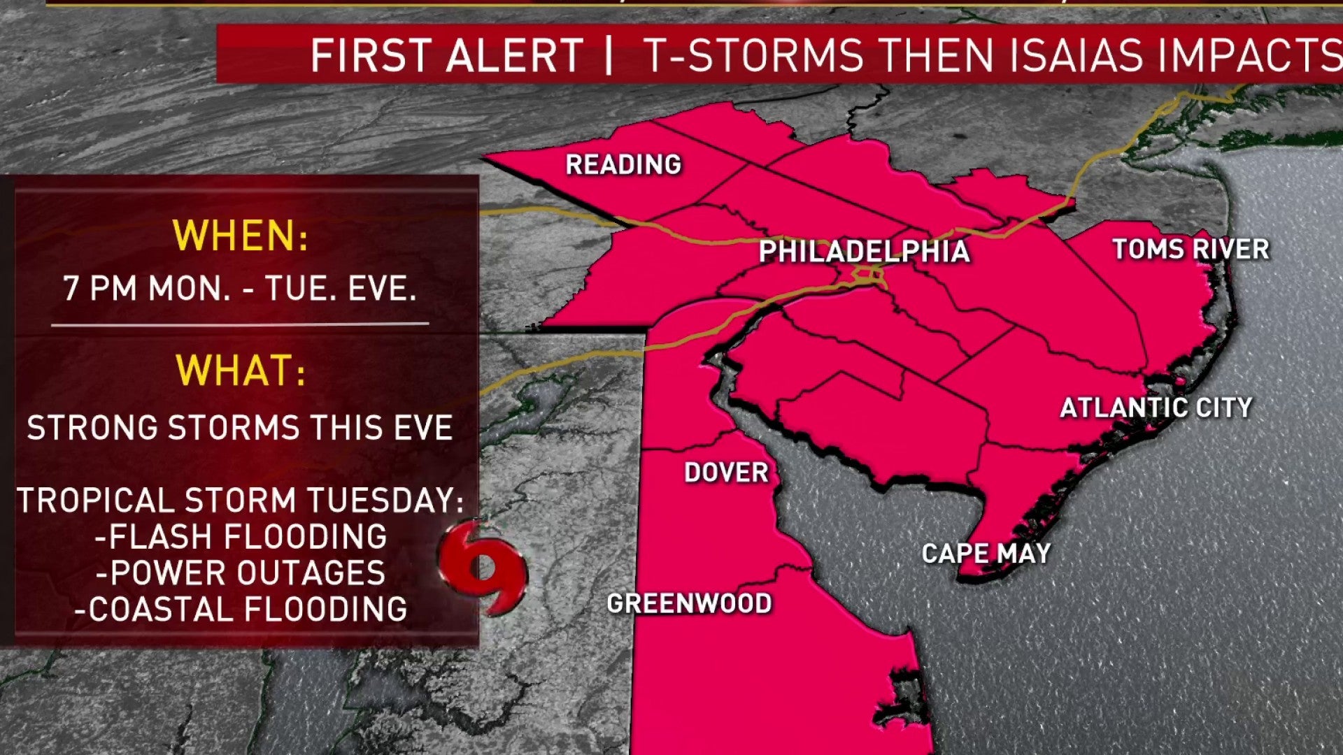
The main impacts from Tropical Storm Isaias will be felt Tuesday as the storm moves in from the south. Philadelphia, the immediate suburbs, New Jersey, and Delaware could have winds gust up to 40 mph, possibly surpassing 50 mph along the coast.
Despite some gusty winds, the biggest impact will be flash flooding with 3 to 5-plus inches of rain possible across the area, with locally higher amounts in heavier rain bands.
This will cause widespread flooding concerns by late Tuesday and Tuesday night. The most vulnerable spots for flooding are in and around Philadelphia, the suburbs, Berks County and the Lehigh Valley. In these areas, it takes much less rain to trigger flash flooding due to soil type and also recent heavy rainfall. Places like Reading, Pennsylvania, were already hit with lots of rain over the weekend.
Power outages are a concern form the heavy rain and wind. So, be sure to power up your devices on Monday.
In addition to heavy rain and strong wind, the coast will also experience dangerous rip currents and coastal flooding. The severity of the coastal flooding is still uncertain, but at least minor coastal flooding at high tide is possible Tuesday and Tuesday evening. Once the storm track is more certain, we will have a better idea if coastal flooding becomes a bigger concern. A moderate risk for rip currents is in effect for the shore Monday with a dangerously high-risk Tuesday.
As of Monday morning, Isaias was off the coast of Georgia, packing near Hurricane-strength winds of 70 mph, the National Hurricane Center said.
Isaias is expected to move quickly past our area and should be gone by Wednesday. Sunshine and pleasant weather return Wednesday and Thursday with highs in the 80s. A much-needed break after the next few days.
Make sure you keep checking back with NBC10 News and download the NBC10 app for the latest on the storm as it moves up the coast.
- Monday: Clouds build, very warm, and humid. Late day and night t-storms. Highs around 90.
- Tuesday: Periods of heavy rain and t-storms. Tropical storm conditions likely in the afternoon and evening. Flash flooding likely the second half of the day. High in the upper 70s.
- Wednesday: Mostly sunny and less muggy. High in the mid-80s.
- Thursday: Mostly sunny and warm. High in the mid-80s.
- Friday: Chance of showers. High in the 80s.
Get daily updates from WHYY News!
WHYY is your source for fact-based, in-depth journalism and information. As a nonprofit organization, we rely on financial support from readers like you. Please give today.

During the aftermath of Hurricane Ida, the Brandywine watershed was hit with the worst flooding in 200 years.
1 year ago
Listen 1:14")
Real estate developer aims to control flooding and erosion in Exton
Hankin Group aims to restore the floodplain along the Lionville Run in Exton, Chester County.
2 years ago
Listen 1:20
New study to determine causes of flooding along Brandywine Creek
The remnants of Hurricane Ida caused the most intense flooding along the Brandywine Creek in 200 years.
3 years ago