Tornado Warnings as Isaias roars through Delaware Valley
The effects of Tropical Storm Isaias are hitting the Philadelphia region, bringing tornado and flooding threats.

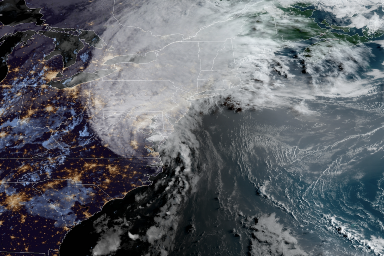
View of Tropical Storm Isaias on Aug. 4, 2020. (NOAA)
This story originally appeared on NBC10.
___
A series of tornado warnings have been issued for parts of Pennsylvania, New Jersey and Delaware as Tropical Storm Isaias roared through the region.
At least one tornado touched down in Delaware, according to the National Weather Service, and several were observed.
Seek shelter in the lowest level of your home and get away from windows — ideally in an interior room — if a tornado warning is issued in your area. You are under imminent danger.
You may not even see the tornado coming since they are forming quickly and may be wrapped in rain. The warnings often pop up quickly and don’t last long.
Two confirmed tornadoes have occurred in Delmarva in the past 30 mins. Please take Tornado Warnings seriously today! #DEwx #MDwx
— NWS Mount Holly (@NWS_MountHolly) August 4, 2020
Observed tornadoes were reported is Sandtown, Kent County; Smyrna, Delaware, where 96 mph winds were reported; and near Strathmere, New Jersey; and another confirmed tornado was reported in neighboring Maryland Tuesday morning, the National Weather Service said.
Tornado warnings in the parts of Philadelphia, Bucks, Chester, Delaware and Montgomery counties in Pennsylvania and parts of Sussex County, Delaware, have expired.
Tornado watches remain in effect for Philadelphia, the immediate suburbs, all of Delaware and South Jersey until 4 p.m.
TORNADO WATCH: In effect until 4 PM. We’ve already had radar indicated tornadoes this AM in Delaware & Philly. Please stay WEATHER AWARE and have a way to get warnings. Flash flooding another big concern. Stay off roads if you can. Drastically better after 4p. @NBCPhiladelphia pic.twitter.com/dqcplY0cfk
— Steven Sosna (@SteveSosnaNBC) August 4, 2020
Stay home, stay off roads and stay alert. Besides tornado threats, Isaias is bringing flooding rains, strong winds and power outages to the region. Tropical storm warnings are in effect for much of the region.
Isaias was downgraded from hurricane strength after it made landfall Monday night in the Carolinas. The storm still packed 70 mph winds and heavy rain as it moved north near the Maryland-Virginia border around 8 a.m. Tuesday.
The outer bands of the storm began lashing the Philadelphia region overnight. And as the storm sped up its greatest impacts began striking the Philadelphia by mid-morning.
A FIRST ALERT is in effect for our area Tuesday due to the stormy impact of Isaias, which is expected to bring flash flooding, power outages, tornado threats and coastal flooding to our region. The First Alert kicked in at 7 p.m. Monday as drenching rain began.
Flash flooding is a greater concern in Pennsylvania, while damaging winds gusts are more likely in Delaware and New Jersey. Inches of rain could fall over a prolonged period of time. Flash flood warnings are in effect for Philly and some suburbs.
Avoid going out on the roads if you don’t need to as heavy rain could quickly cause flooding. Route 309 southbound Some SEPTA Regional Rail trains were delayed by up to 45 minutes.
Gov. Phil Murphy declared a State of Emergency for New Jersey Monday night ahead of Isaias. Motor Vehicle Commission offices were also closed Tuesday.
UPDATE: I am declaring a STATEWIDE STATE OF EMERGENCY for Hurricane Isaias effective at 5:00 AM on Tuesday, August 4, 2020:
☑Do not be on the roads unless absolutely necessary
☑If you MUST drive, take it slow, use caution, and leave extra time to get to your destination pic.twitter.com/mMDUJsPhal— Governor Phil Murphy (@GovMurphy) August 4, 2020
Tropical storm warnings were already in effect Monday for area counties in Pennsylvania, New Jersey and Delaware, with the exception of Berks County and the Lehigh Valley. The risk of flash flooding, damaging wind and heavy downpours spreads to the entire region, including the northern and western suburbs.
See It, Share It: If you can safely take photos or videos of storm damage please send it to NBC10.
Rain could fall at 1 to 3 inches per hour during the heaviest rain bands expected late morning into the early afternoon. Widespread street, urban and stream flooding is expected from the heavy rain.
Even if rain slows or ends, winds could kick up and cause issues. Wind gusts up to 40 mph are possible in the Lehigh Valley, 60 mph in Philadelphia and 70 mph at the Shore. Widespread power outages are possible from these gusts.
Isaias is moving in from the south. The most widespread impact is expected to be flash flooding with 3 to 6-plus inches of rain likely across the area, with locally higher amounts in heavier rain bands. Some places could get 8 inches or more of drenching rain.
This will cause widespread flooding concerns Tuesday. The most vulnerable spots for flooding are in and around Philadelphia, the suburbs, Berks County and the Lehigh Valley. In these areas it takes much less rain to trigger flash flooding due to soil type and also recent heavy rainfall. Places like Reading, Pennsylvania, were already hit with inches of rain over the weekend.
Areas prone to flood, like the Brandywine Creek, face a big threat of flooding Tuesday.
This is all the rainwater that drains from higher grounds, roads, grassy areas into rivers and creeks. We are expecting hours of rain like this @NBCPhiladelphia pic.twitter.com/A1A9K4qt7O
— Randy Gyllenhaal (@RandyGyllenhaal) August 4, 2020
Power outages are a concern form the heavy rain and wind. So, be sure to power up your devices.
In addition to heavy rain and strong wind, the coast will also experience dangerous rip currents and coastal flooding. The severity of the coastal flooding is still uncertain, but at least minor coastal flooding at high tide is possible Tuesday and Tuesday evening. Once the storm track is more certain, we will have a better idea if coastal flooding becomes a bigger concern. A dangerously high risk for rip currents is in effect Tuesday.
As of Monday night, Isaias made landfall in North Carolina with strong winds and heavy rainfall.
Isaias is expected to move quickly past our area as conditions could already start improving by late Tuesday afternoon. Conditions will improve from south to north starting around 3 to 4 p.m.
Sunshine and pleasant weather return Wednesday and Thursday with highs in the 80s, though there is a rain risk on Thursday.
Make sure you keep checking back with NBC10 News and download the NBC10 app for the latest on the storm.

Get daily updates from WHYY News!
WHYY is your source for fact-based, in-depth journalism and information. As a nonprofit organization, we rely on financial support from readers like you. Please give today.


