

Get used to a Philly summer that’s expected to be a scorcher
A blistering weekend is a forecast of things to come. NOAA points to a hot, rainy summer for the mid-Atlantic. Plus, the hurricane forecast for 2022 is out this Tuesday.


File photo: Fire hydrants were opened around the city during an historic heatwave in Philadelphia in 2018. NOAA predicts higher-than-average temperatures for Philadelphia for the summer of 2022. (Kimberly Paynter/WHYY)
Scorching temperatures arrived in Philadelphia one week before Memorial Day Weekend, making late spring feel like the dog days of summer and tying a record with Saturday’s 95 degree high. While the record for Sunday remains at 96 degrees, set back in 1941, the weekend’s sweltering heat is not normal weather for this time of year.
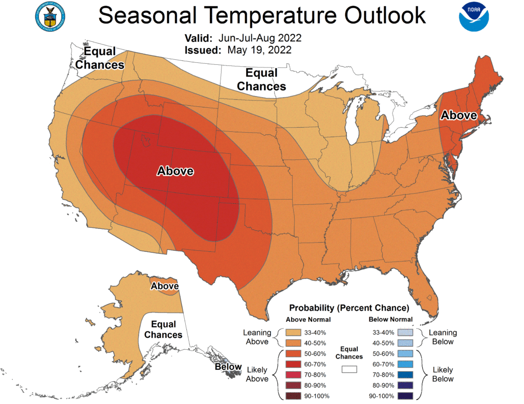
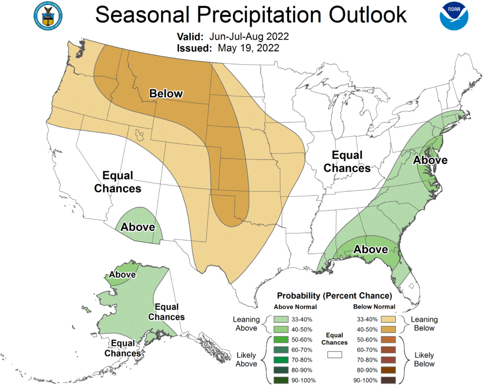
To make matters worse, the weekend heat wave could be a prelude to what federal climate scientists say will be a hot summer ahead. The Mid-Atlantic region — which includes Delaware, New Jersey, and the eastern part of Pennsylvania — is expected to experience above average temperatures in June, July, and August, according to NOAA’s Climate Prediction Service.
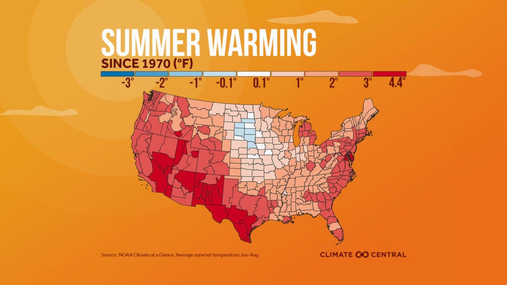
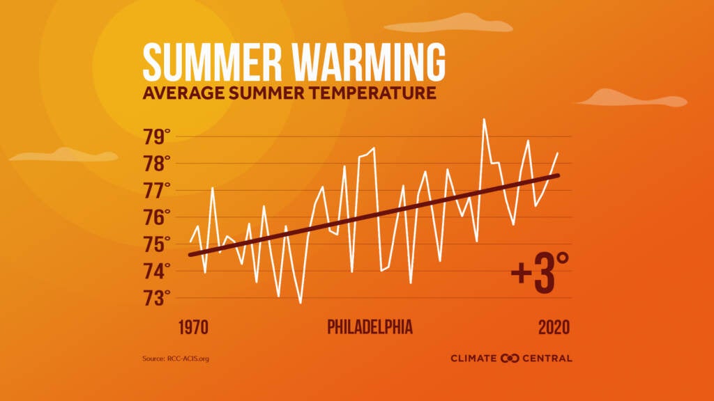
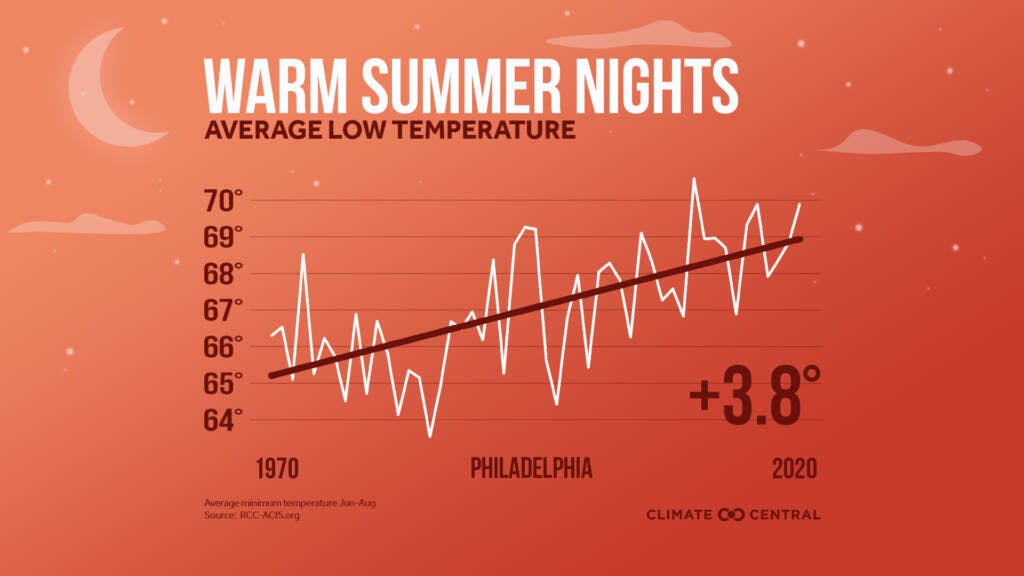
Climate change is causing the average temperatures in the region to climb. Philadelphia’s average summer temperature rose 3 degrees between 1970 and 2020, according to an analysis by Climate Central. What makes life even more difficult, and dangerous for some, is the lack of reprieve when nighttime temperatures don’t cool down. Summer nights in Philadelphia have risen on average 3.8 degrees in that same 50-year period. Hotter nights without air conditioning can be hard on our bodies, and disrupt sleep. The high heat days contribute to increased air pollution and ozone, leading to health impacts like asthma and strokes.
NOAA also reports the region will likely experience above average rain in the coming months.
Related Content

Philly ‘spraygrounds’ open a week early ahead of possible record temps
Temperatures in several places are expected to break daily records, with high humidity. Remember to stay hydrated and be careful working outside.
4 years ago
The end of May and into June is considered a time of extreme weather in this part of the country, according to Jared Guyer, lead forecaster for NOAA’s Storm Prediction Center.
“Things will undoubtedly become more active,” said Guyer. “More severe weather in more areas over the next 30 to 60 days or so.”
Guyer says the severe weather is not necessarily abnormal for this time period. “But even when things are quiet, [local] severe weather is very impactful,” he said. “Severe weather tends to be local and impactful especially when you’re thinking about tornadoes and larger hail and damaging winds.”
In addition to the unpredictable pop-up thunderstorms, hail, and tornadoes, hurricane season starts next week. NOAA plans to issue its prediction for the number and severity of those storms Tuesday.
Expect the next several days to ease back into normal spring temperatures, with no storms on the horizon, yet.
Get daily updates from WHYY News!
WHYY is your source for fact-based, in-depth journalism and information. As a nonprofit organization, we rely on financial support from readers like you. Please give today.

Philadelphia snow updates: Sleet takes center stage; latest snowfall totals
Significant snow accumulations are impacting Pennsylvania, New Jersey and Delaware. Here’s everything you need to know.
2 months ago

Here’s what to know about this weekend’s storm, from the forecast and weather advisories to travel impacts and more.
2 months ago

New Jersey offers grants to tackle the urban heat island effect
New Jersey’s temperatures are rising at a faster rate than many other states. The state is offering grants to communities to prepare for climate change–related heat waves.
8 months ago