Lots of rain in 2018 made local rivers run high and fast. Will climate change make that a regular thing?
Last year was the second rainiest on record in Philadelphia, with a total 61.6 inches over the year.

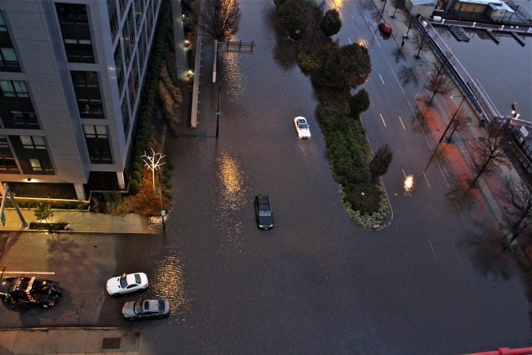
Cars are stranded on Columbus Boulevard in Philadelphia on Nov. 26, 2018, after flooding made the road impassable. (Emma Lee/WHYY)
If you remember 2018 as being one rainstorm after the next, you aren’t far off.
Last year was the second rainiest on record in Philadelphia, with a total 61.6 inches over the year. That’s only narrowly edged out by 2011 – the year of Hurricane Irene and Tropical Storm Lee – when Philadelphia soaked up 64.3 inches of rain. The cities of Wilmington and Reading, as well as the entire state of New Jersey, recorded their rainiest year.
All that rain propelled some of the highest river flows on record. The Schuylkill in Philadelphia flowed at its highest rate since scientists began recording data in 1932. Ditto with the Delaware near Montague, New Jersey, where records date to 1940. In Trenton, the Delaware flowed at its second highest rate, with first place going to 2011.
Carol Collier, senior adviser for watershed management and policy at the Academy of Natural Sciences, said she wasn’t surprised by the numbers given all the rain we had. But the region isn’t prepared for the higher flows and more frequent floods that could happen as a result of climate change, she said.
“You can’t stop floods,” she said. “But you can mitigate the impacts of floods. And that’s what we need to work on.”
Collier is the former executive director of the Delaware River Basin Commission, which released the flow rate data and regulates Delaware River water quality and quantity.
“I think it does present a more pressing problem because we are not as prepared as we could be,” she said.
Some of the rain last year came in the form of gentle showers. But much of it came from intense storms that caused flash flooding.
The ever-changing weather
Scientists say the overall amount of rain an area receives in a year is difficult to tie to climate change because there is so much natural variability when it comes to weather.
“The sort of background variability in the climate, which is perfectly natural, just wiggles around,” said Raymond Najjar, a climate scientist and professor of oceanography at Penn State University. “That’s always there. Whereas the signal from greenhouse gases, the impact that has is gradual, and it could show up in extreme events. And it could make them more likely, but it’s still happening on a background of pretty high variability.”
But one thing the data do support is the effect climate change has on the intensity of storms and the number of them. For example, Najjar said, if you compare the rainiest day of the year in the region to other rainiest days in the past, the trend generally shows that the amount of rainfall has increased in step with increased greenhouse gas emissions. And the data also show more of those events per year.
Najjar said the extreme rain events cause more erosion and runoff, which ends up in rivers and oceans.
“The amount of sediment that’s eroded from a watershed and dumped into an estuary depends not so much on the total amount of precipitation but on the intensity of the precipitation,” he said.
“Having more of the precipitation come in heavy events than, say, in a drizzle is going to lead to proportionately more input of sediment and possibly other things that affect the ocean.”
And there’s a lot of uncertainty about how rising temperatures will affect river flows in the long run. As temperatures rise, so might evapotranspiration — the evaporation of river water into the atmosphere.
Collier also cited the likelihood of more intense droughts as well as more intense floods and storms. That means rivers may not always run high and fast.
“Both of those extremes can become more extreme,” she said. “We are projected to have more or slightly increased amount of rainfall on an annual basis, but that doesn’t mean it will be distributed evenly across all 12 months.”
WHYY is your source for fact-based, in-depth journalism and information. As a nonprofit organization, we rely on financial support from readers like you. Please give today.


