Hurricane Lee is rapidly intensifying, and it’s forecast to be a Category 5 storm

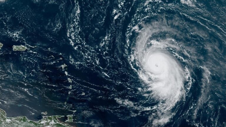
Hurricane Lee formed a well-defined eye wall on Thursday. The storm is seen here in a satellite image from around noon ET Thursday, showing the Leeward Islands and Puerto Rico to the west. (NOAA/NESDIS/STAR)
Hurricane Lee is exceeding expectations as it becomes the fearsome storm it was predicted to be, undergoing “rapid intensification” as it moves across the Atlantic Ocean, forecasters said on Thursday. The hurricane’s maximum winds are now predicted to top 160 mph by this weekend.
Lee currently has maximum sustained winds of 105 mph and is over open water, following a west-northwest path that will likely see its center pass north of the Leeward Islands and Puerto Rico, the National Hurricane Center said in its latest advisory.
Lee is expected to become a major hurricane on Thursday — a designation for Category 3 storms and above. That means its sustained winds would roar at 111 mph on the same day that it developed a well-defined eye.
Lee is forecast to intensify at ‘remarkable rates’
The hurricane center has repeatedly warned that Lee could become very powerful in an exceptionally short time. That guidance has now become even more dire, as the NHC said many forecasting tools “are calling for remarkable rates of intensification, beyond rates normally seen with model forecasts.”
The main question right now, the NHC says, is “how strong Lee will get, and how quickly will it get there.”
If Lee’s sustained winds surpass 160 mph as expected, that would make it a Category 5 storm (the threshold is 157 mph).

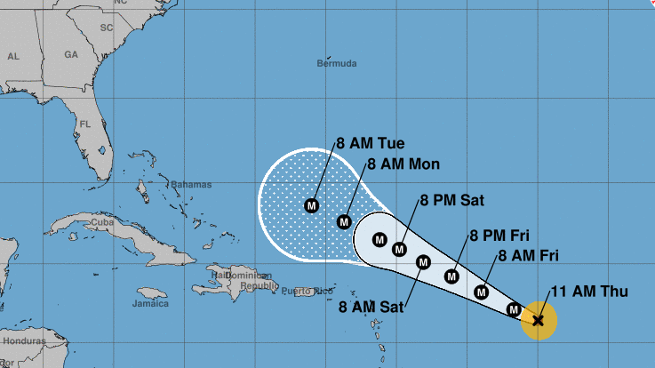
The hurricane center’s forecast track currently predicts that Lee will churn north-northwest, reaching a point well north of Puerto Rico by Tuesday morning. So far, the storm isn’t posing an immediate threat to anyone on land. But experts advise keeping a close eye on the storm.
“The potential for tropical storm conditions to occur in [the northern Leeward Islands, the Virgin Islands, and Puerto Rico] is decreasing, but residents there should continue to monitor updates on Lee,” the NHC said.
All eyes are on the storm’s path
It’s too early to say with certainty whether Lee might make landfall anywhere, or if it will spin harmlessly away from the U.S. Atlantic coast and other land masses.
Several long-range models currently have Lee eventually curving north — missing the Caribbean and remaining offshore. While models are generally accurate, they’re not perfect. Hurricane Irma, in 2017, was supposed to follow a similar path — instead, it walloped Florida’s Gulf coast.
Even if Lee misses land, forecasters say swells generated by the storm “are expected to reach portions of the Lesser Antilles on Friday, and the British and U.S. Virgin Islands and Puerto Rico this weekend. These swells are likely to cause life-threatening surf and rip current conditions.”
The system has been gaining power as it passes over “record-warm waters of near [86 degrees Fahrenheit] east of the Lesser Antilles,” the NHC said this week, adding that such warm waters are more expected in the Gulf of Mexico, not the Atlantic Ocean.
Lee is the 13th named storm of what is an above-average Atlantic hurricane season. As researcher Phil Klotzbach notes, only “4 other years on record have had 13+ Atlantic named storms by Sept. 5: 2005, 2011, 2012, 2020.”
9(MDAzMzI1ODY3MDEyMzkzOTE3NjIxNDg3MQ001))


