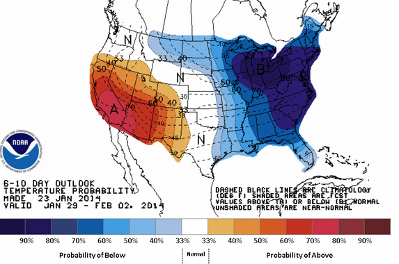
Well below normal temps to persist; light snow Sat, possibly more upcoming

A temperatures outlook from the National Weather Service, indicating a high probability of below normal temperatures in the region during the six to 10 day period.
Old Man Winter isn’t going anywhere anytime soon, forecasters say.
Forecast models have been “consistency showing little change in the pattern for the next three to four weeks,” according to a National Weather Service forecast discussion.
While there is some variability for a “day or two per week” of near normal temperatures, the developing persistent cold pattern assures well below normal temperatures for the remainder of January “and probably through a good chunk of early February,” the forecast discussion advises.
And it’s not just the cold.
There will be upcoming “possible snow events with increasing chances of significant [precipitation] events in February,” according to the forecast discussion.
In the short term, beginning Saturday, the Friday afternoon snowfall map from the National Weather Service office in Mount Holly, N.J. indicates a coating to four inches of snow in New Jersey, with two to four inches in northwest areas. Progressively less amounts will fall from the northwest to southeast, with generally one to two inches in the I-95 corridor and an inch or less near the coast.
Most of the snow will fall between 10 a.m. and 4 p.m. Saturday.
Another system may deliver snow to northern areas Sunday night into early Monday, but it will be weaker than Saturday’s system and accumulations would be lighter, forecasters advise.
The last snowfall potential in the short term is on Wednesday, when forecast models indicate a low developing off the Southeastern United States that heads north.
But while “the vast majority” of the forecast models keep the system “well off the coast with no impact on our weather,” the forecast discussion notes, one model (the EURO) has a slightly more western track that “brings a glancing blow to our eastern areas” on Wednesday.
So for now, forecasters say they’re monitoring the chance for snow in eastern areas.
Stay tuned!
WHYY is your source for fact-based, in-depth journalism and information. As a nonprofit organization, we rely on financial support from readers like you. Please give today.

