

Overnight snow moving out; snow, ice threaten Valentine’s Day weekend
Snow and ice are in the forecast multiple times into next week. The NBC10 First Alert Weather Team is tracking the wintry weather chances.

File photo: A person, reflected in a window while wearing a face mask during a winter storm in Philadelphia, Monday, Feb. 1, 2021. (AP Photo/Matt Rourke)
This story originally appeared on NBC10.
Keep the winter weather gear near as you could be waking up to snow on the car and driveway Thursday morning. And, more snow and ice is expected in the Philadelphia region this Valentine’s Day weekend.
A cold and wintry pattern has its grip on the Delaware Valley — leading to days of snow already since the calendar turned to February — and it’s continuing in the days to come.
The key is to stay flexible as changes that can happen fast could drastically change the impact of a storm in your neighborhood.
Related Content

What a ‘Code Blue’ means for Philly residents
When temperatures feel near or below 20 degrees Fahrenheit, Philadelphia officials will declare a Code Blue. Here’s what that means, and how you can help.
5 years ago
Here is what we know at this point:
Snow could mess with morning commute
The first shot for accumulating snow that could impact your daily routine is expected into Thursday morning.
The First Alert Weather Team issued a First Alert for snow for the entire Philadelphia region until 10 a.m. Thursday.
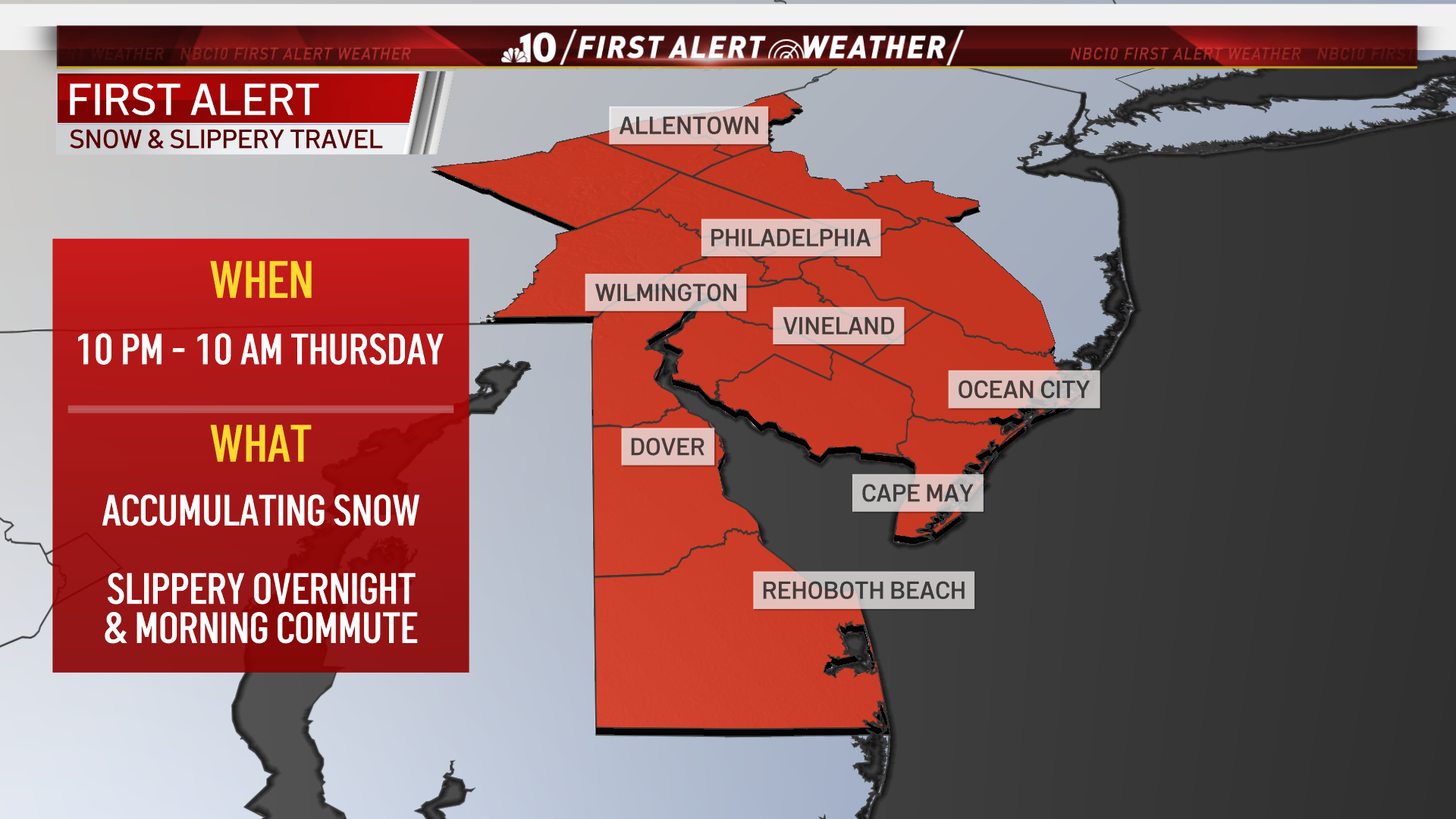
The heaviest snow totals, at this point, appear to be just south of Philadelphia — across South Jersey and Delaware. Those neighborhoods are expected to get multiple inches of accumulation before the snow leaves. Middletown, New Castle County, already had reported 3.8 inches of snow while Forked River, Ocean County reported 4 inches before daybreak.
Expect slippery travel in Philadelphia, the Pennsylvania suburbs, Berks County and Mercer County where snow stuck to roadways and sidewalks.
Overnight, the heaviest snow fell in Philadelphia and the suburbs. It even had wrapped up in some places before daybreak.
Related Content

Towed during a ‘snow emergency,’ Philly resident’s car goes missing for a week
Memorize these routes or make sure you’re signed up for OEM alerts if you want to keep your vehicle away from the PPA during the next storm.
5 years ago
The steadiest snow bands are expected until around 10 a.m. across South Jersey, Delaware and shore points.
Philadelphia Catholic parish and regional elementary school will open two hours late while Archdiocesan high schools will be on a two hour delay plan for virtual delivery of instruction on Thursday due to the snow.
Several other districts in our region are opening late on Thursday as well.
The storm is expected to wrap up during the late morning, but clouds should linger. Temperatures will only get slightly above freezing Thursday, so don’t expect major melting to occur.
Be prepared to give yourself extra time to get out the door and to dig out from whatever sticks to the ground and your car.
Valentine’s Day weekend weather
The run of wintry potential continues on Saturday into Sunday. Here’s what we expect as of midday Wednesday.
A storm is expected to arrive Saturday afternoon as light snow and ice depending on where you are. The brunt of the storm is expected to be Saturday night into Sunday morning when significant snow and ice are expected.
It is too soon at this point to pinpoint exactly what to expect in which neighborhoods as the snow/ice line could shift. Impacts should become clearer as we approach the weekend.
More snow, ice ahead
As this parade of wintry weather continues its march through our region, more snow and ice are threatening next week, with the first chance Tuesday.
Never miss a moment with the WHYY Listen App!
WHYY is your source for fact-based, in-depth journalism and information. As a nonprofit organization, we rely on financial support from readers like you. Please give today.

Nor’easter to bring weekend snow to Delaware Valley
A Blizzard Warning has been issued for areas along the coast, while a Winter Storm Warning will be in effect for much of the Delaware Valley.
4 years ago
Messy morning commute in Philly region ahead of snow
The Delaware Valley is under a Winter Weather Advisory until either 11 a.m. or 1 p.m. Thursday, depending on the county.
4 years ago
Steady snow moving through Philadelphia region
Parts of the region could see between 4" to 6" of snow. Here’s what you need to know.
4 years ago