NWS: Blizzard to now dump 12-18" in portions of Shore
Blizzard conditions are impacting the Jersey Shore Thursday morning.

Blizzard conditions are impacting the Jersey Shore Thursday morning, and forecasters now say snow accumulations will be higher than predicated.
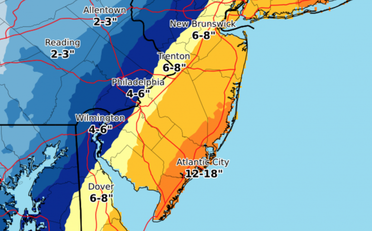
The National Weather Service is now calling for 12-18″ of snow from coastal Ocean County south to Cape May County, with 8-12″ elsewhere at the Shore.
630A Updated snow fcst attached. Dangerous conds today through Sat night if trapped outside. Coastal flooding within 2 hrs high tide this morng. 40-60 MPH gusts coastal NJ/DE tdy. Record cold Fri night-Sat night. Snow and flood reps here if time and safe. #njwx #dewx #pawx #mdwx pic.twitter.com/RDYjtlG8FS
— NWS Mount Holly (@NWS_MountHolly) January 4, 2018
Egg Harbor Township in Atlantic County and Wildwood in Cape May County have already registered a half-foot of snow as of around 6 a.m., according to the National Weather Service.
With winds whipping around snow, visibilities are reportedly low throughout the Shore, and travel is dangerous. JSHN contributors are reporting poor roadway conditions throughout the Shore.
The National Weather Service says the heaviest snow will fall between 7 a.m. and 1 p.m., tapering off this evening.
Minor tidal flooding is likely during the morning high tide cycle. Any water that does not recede will freeze over.
Gov. Chris Christie closed state offices at 8:30 a.m. and declared a state of emergency for Monmouth, Ocean, Atlantic, and Cape May counties. Essential employees should report on schedule.
State courts in Atlantic, Cape May, Hudson, Monmouth, and Ocean counties are closed, including Tax and Appellate courts. The remainder will open two hours late. Check with your local municipal court for for closing information.
Schools throughout the Jersey Shore are closed.
❄Sound On❄ Please stay off the roadways if possible, dangerous conditions, update from #harveycedars @NWS_MountHolly @6abc @NBCPhiladelphia @FOX29philly @News12NJ pic.twitter.com/zZ6NMvwg4D
— Harvey Cedars Police (@HCPolice) January 4, 2018
#Grayson Starting to pile up! #StoneHarborNJ pic.twitter.com/wsBh4e3GAr
— Zeke Orzech (@Zeke_O) January 4, 2018
First look #Capemay #grayson @garyszatkowski. Knee deep drifts. Blowing snow like needles hitting face. Plows working hard to keep up. #jerseyshore #jshn @6abcactionnews #njwx pic.twitter.com/lhTxHKc0QI
— John Cooke (@CookeCapeMay) January 4, 2018
This storm is putting on a helluva show from space, with GOES-16 imagery. Note the enhanced cloud tops along NJ coast associated with heavy snow band there. pic.twitter.com/Ysya9mwBGf
— Andrew Freedman (@afreedma) January 4, 2018
Video from Ventnor Avenue in Ventnor. #grayson #WinterStorm @ThePressofAC pic.twitter.com/vLcdslFtre
— Max Reil (@acpressmaxreil) January 4, 2018
Wind is whipping up on the bay front pic.twitter.com/RD8TCjCTrF
— Lt. Keith Germain (@BTPD318) January 4, 2018
WHYY is your source for fact-based, in-depth journalism and information. As a nonprofit organization, we rely on financial support from readers like you. Please give today.


