NHC: “Very large uncertainty” in Hurricane Florence’s forecast track

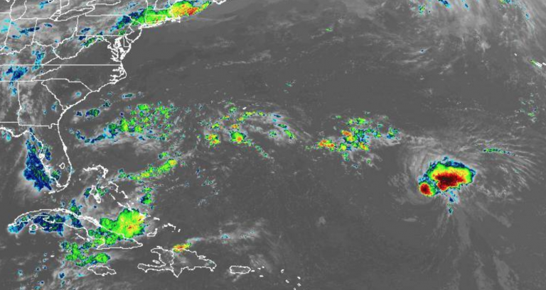
In this Thursday evening NOAA infrared satellite image, Hurricane Florence is in the lower right portion of the frame.
Forecasters are monitoring the potential for an East Coast impact by Hurricane Florence, a weak cyclone situated about 1,000 miles southeast of Bermuda early Thursday evening.
For now, the operative word remains potential, because “uncertainty in the forecast remains larger than normal,” according to the National Hurricane Center.
Florence decreased in intensity from a Category 4 on Wednesday to a Category 1 cyclone on Thursday due to entering into an unfavorable environment, the center says.
But the forecasters expect Florence to enter into more favorable conditions by the weekend, allowing the cyclone to potentially achieve major hurricane status by early next week.
Whichever direction #Florence goes, above normal water temperatures await. Once shear weakens, Florence may re-gain major hurricane strength upon its U.S. approach. pic.twitter.com/RWvUR7KvYz
— Ed Vallee 🌽 Vallee Wx Consulting 🌾 (@EdValleeWx) September 6, 2018
And that’s when the uncertainty about Florence’s track is highly uncertain, as global forecasting models differ on the potential path. The local National Weather Service office says the track depends of the “placement and strength of the ridge of high pressure centered over the western Atlantic.”
While it’s quite possible that Florence can move harmlessly out to sea, two major models, the European and American, showed a noticeable shift toward the west on Thursday.
JUST IN: Hurricane Florence has weakened to a Category 1 hurricane and may be downgraded a tropical storm in the next 24 hours, but is still expected to reintensify to a Cat 3 by early next week. https://t.co/0YQS2RTrDE
— Capital Weather Gang (@capitalweather) September 6, 2018
With a potential impact on the mainland United States a week or more away, the National Hurricane Center says “it is too soon to determine what, if any, other impacts Florence could have on the U.S. East Coast.”
Nevertheless, beachgoers should take precautions.
“Regardless of Florence’s eventual track, large swells will begin to affect Bermuda on Friday and portions of the U.S. East Coast this weekend, resulting in life-threatening surf and rip currents,” a late Thursday afternoon National Hurricane Center discussion advises.
And the Jersey Shore should, as always, have a hurricane plan in place if the threat increases.
— Manasquan Borough (@ManasquanOEM) September 6, 2018
Residents should continue to closely monitor the forecast over the coming days. But the National Weather Service says to step back before sharing “scary-looking” model runs that might appear on your Facebook timeline.
“Focus on one model run and any single deterministic track at this time range is ill-advised and scientifically indefensible,” the forecasters warn.
WHYY is your source for fact-based, in-depth journalism and information. As a nonprofit organization, we rely on financial support from readers like you. Please give today.


