Monmouth County’s coastal evacuation map is first of its kind in N.J.

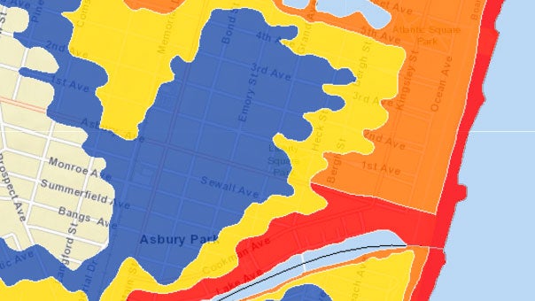
This is an image of the evacuation zones for Asbury Park
Just before the fourth anniversary of Superstorm Sandy, Monmouth County has instituted a tiered coastal evacuation plan designed to simplify messaging during a storm surge threat.
Through four distinct zones — A, B, C, & D — “Know Your Zone” helps emergency management officials target evacuation orders to those areas that are at the most risk, based upon threat, strength, direction and forecasted storm surge.
“As Monmouth County continues to lead the way in storm preparedness, and build upon the lessons learned from Superstorm Sandy, this program was essential to develop in an effort to maintain the utmost safety when dealing with a major storm,” Sheriff Shaun Golden said in a release. “KNOW YOUR ZONE, which is the first program of its kind in New Jersey, directs evacuation orders to those who are at the greatest risk of being impacted by storm surge and flooding, the deadliest components of coastal storms.”
Monmouth County OEM Coordinator Mike Oppegaard said the zones were “created by various hypothetical storm models based on worst case scenarios and should not be confused with flood zones as established by National Flood Insurance Rate Map.”
County officials say the public needs to understand the following points:
Evacuation zones should not be confused with flood zones.
The evacuation zones are based on storm surge values using various hypothetical storm models based on worst case scenarios.
The zones have been established based on threat strength direction and storm surge.
Localized evacuation orders may be issued by Municipal Emergency Management officials during storms that are forecasted to have area specific impacts, rather than county-wide impacts.
You can see your zone by visiting here.
WHYY is your source for fact-based, in-depth journalism and information. As a nonprofit organization, we rely on financial support from readers like you. Please give today.

