

The mid-Atlantic region could see fewer hurricanes this year, but climate change could still make them worse
NOAA is rolling out an experimental tool to help emergency planners predict extreme rain events in 60 cities, including Philadelphia and Dover, Delaware.
Listen 1:08

An aerial view of Hurricane Erin off the East Coast of the United States. (Courtesy of NOAA)
This story is part of the WHYY News Climate Desk, bringing you news and solutions for our changing region.
From the Poconos to the Jersey Shore to the mouth of the Delaware Bay, what do you want to know about climate change? What would you like us to cover? Get in touch.
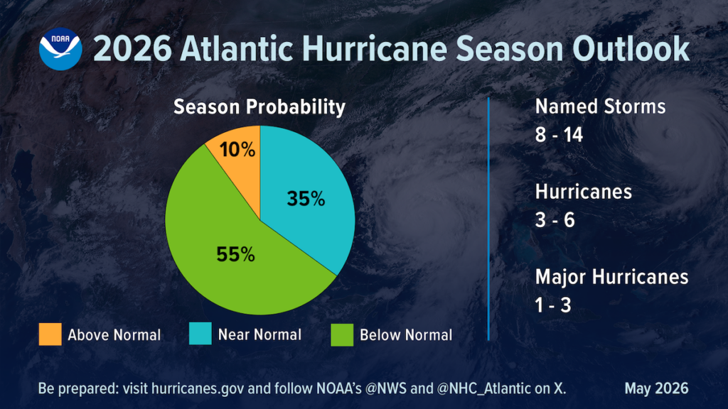
The mid-Atlantic region is expected to see lower than average hurricane activity this year, according to predictions by the National Oceanic Atmospheric Administration’s National Weather Service.
NOAA officials predict eight to 14 named storms, of which three to six could become hurricanes. During a news conference Thursday, the agency said it predicts one to three major hurricanes to form in the Atlantic Ocean. Hurricanes have wind speeds above 74 mph, while major hurricane winds top 111 mph. The predictions are for formation, not landfall. In 2025, five hurricanes formed in the Atlantic, but none made landfall in the U.S.
The expected decrease in typical storm activity is due to El Niño, which NOAA officials said has a 98% chance of forming this summer. El Niño is expected to bring strong atmospheric winds, known as shear, which act to break up the formation of hurricanes.
“Although El Niño’s impact in the Atlantic Basin can often suppress hurricane development, there is still uncertainty in how each season will unfold,” Ken Graham, NOAA’s National Weather Service Director, said.
Graham encouraged residents to prepare despite the outlook for a less intense season.
“There’s no such thing as ‘just a’ Cat 1, just a tropical storm, ‘just a’ Cat 2,” he said, referring to the intensity ratings of a storm, or categories. “You got to look at the size, the forward motion, little wiggles matter on the impacts. Even the smallest storm, if it’s slow enough and big enough, it’s going to be catastrophic flooding and storm surge,” Graham said.
Graham said more than half of the storm-related deaths over the past 10 years were caused by flooding, most of which were people who died while trapped in their cars.
“I don’t think the public fully realizes that 6 inches of fast-moving water will knock you off your feet,” Graham said. “Twelve inches will carry most cars away, and even people that think ‘I got some big giant SUV.’ Well guess what? About a couple of feet of water will wash that one away too.”
It doesn’t take a hurricane-level storm to cause deadly flooding. In July 2023, seven people, including two young children, died in Bucks County after a flash flood trapped their vehicles along Washington Crossing Road in Upper Makefield Township.
Graham said the category and the name of storms are not what people should pay attention to, but rather to the impacts forecasters say will come with them.
Related Content

An initial assessment by the state Department of Agriculture finds at least $300 million in crop losses reported by farmers.
2 months ago
New tools to help predict flooding in Philadelphia and Dover
This year, NOAA announced several new forms of technology aimed at helping local emergency planners with detailed information. The agency’s Office of Water Prediction provides a Flood Inundation Mapping service that allows users to drill down to street level in areas likely to be underwater during a storm. While still under development, the mapping service is expected to cover the entire U.S. population by the end of September.
NOAA also launched the experimental Urban Rain Rate Dashboard, which can show the probability of extreme rainfall a week in advance for 60 urban areas including Philadelphia, and Dover, Delaware.
In order to improve predictions of intensity, NOAA for the first time will use data from uncrewed aircraft systems into its modeling.
Climate change continues to drive the intensity of tropical storms
Despite the expected formation of El Niño, which is expected to reduce the number of storms this season, global sea surface temperatures are at record levels, similar to what occurred in 2024, said Shel Winkley, a meteorologist with the nonprofit Climate Central.
“About 90% of the excess heat trapped by greenhouse gas pollution has gone directly into our ocean, that’s the way that the earth tries to keep our atmosphere in balance is by absorbing that carbon,” Winkley said.
Climate scientists say the warming oceans supply more fuel for the seasonal storms. For that reason, global warming is causing more intense tropical storms and hurricanes, which when they hit land produce stronger winds and heavier rain.
In the past five years, climate change has increased the intensity of more than 95% of all hurricanes, said Daniel Gilford, a meteorologist and atmospheric scientist with Climate Central.
“And so there is this back and forth interplay between the El Niño suppressing the storms and the warm waters available to supercharge the storms,” Gilford said. “When a storm does spin up, it will see those warm waters in the Atlantic Ocean … and it will start to grow, and it could intensify and become a very major storm indeed. There is a ton of warmth out there for these hurricanes to take advantage of if they’re able to kind of get around the [wind] sheer constraint.”
Hurricane season runs between June 1 and Nov. 30. NOAA is expected to update its predictions in August.
Get daily updates from WHYY News!
WHYY is your source for fact-based, in-depth journalism and information. As a nonprofit organization, we rely on financial support from readers like you. Please give today.
Part of the series

Reprieve from wildfire smoke expected to come over the weekend, meteorologists say
Rainfall and a change in wind direction are expected to push the smoky air away from Philadelphia.
1 week ago

Philly pools closed, trash pickup canceled due to very unhealthy air
Wildfire smoke is bringing very unhealthy air pollution to the Philadelphia region. Officials say everyone should avoid optional outdoor activities.
1 week ago
Listen 0:58
Wildfire smoke sparks Code Red air quality warning for Pennsylvania
Air quality in the Philadelphia region is forecast to be unhealthy for everyone Thursday. Officials advise limiting outdoor activities.
2 weeks ago