From Above: Roosevelt Boulevard, Oxford Circle and beyond in 1927

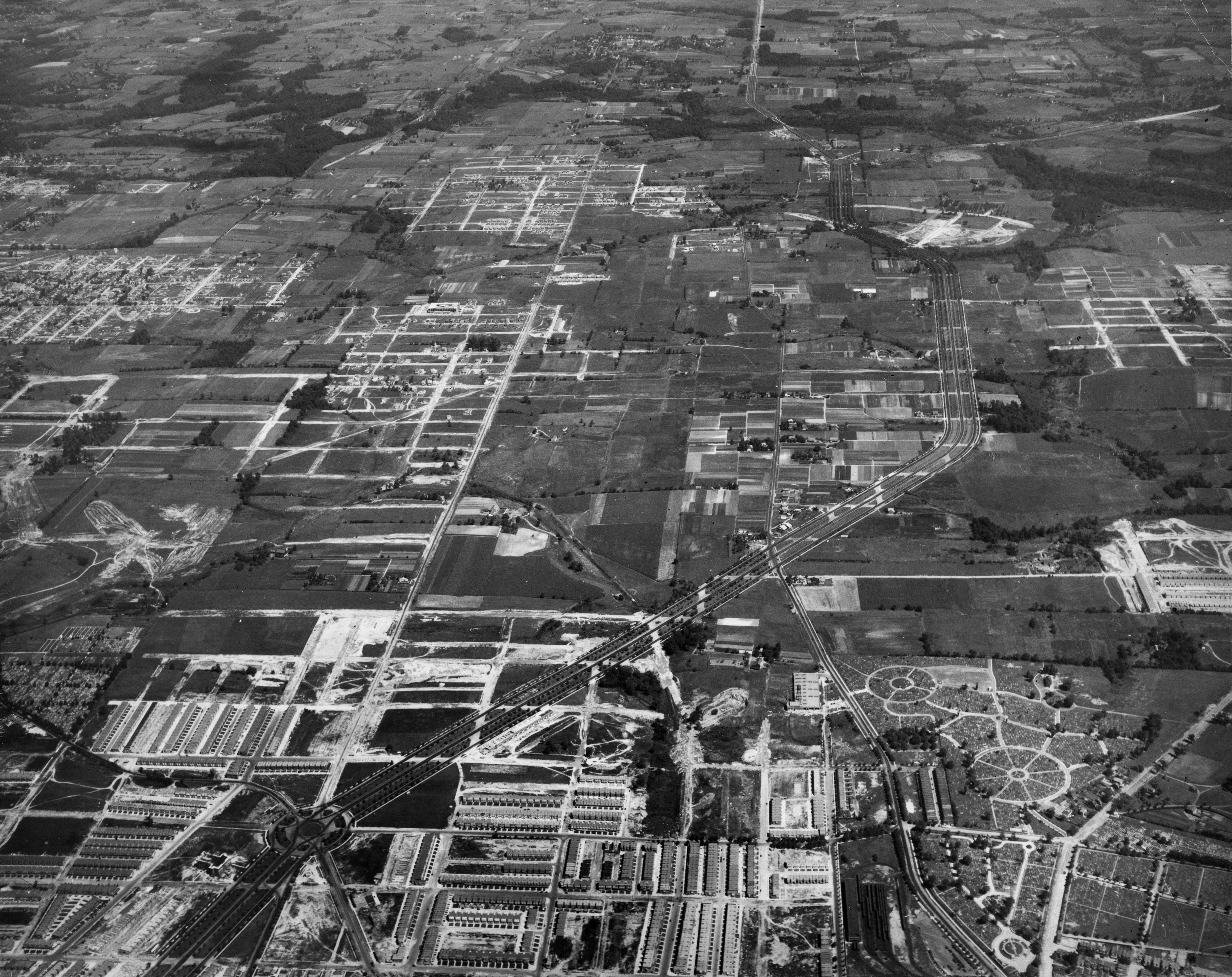
This week the great hyperlocal news site NEastPhilly.com announced that they’ll cease publication on December 31, 2013. So in tribute to their five years of devoted Northeast Philly coverage, we turn our eyes to this historic view of the Lower Northeast. Here’s a look at the Boulevard north from Oxford Circle from 1927. Just look at how much this area of the Lower Northeast has changed in nearly 100 years.
In 1927 the Roosevelt Boulevard is in its second decade of use and had helped extend the reach of dense city living into what was the Northeast Philadelphia countryside. In this view, facing north from somewhere above Frankford, we see the Boulevard’s familiarly wide tree-lined path as it heads northward from Oxford Circle, which is near the lower left corner of the frame. And it’s easy to spot Oxford Circle’s spokes: Castor Ave (extending stright up), Cheltenham Avenue (crosses frame left to right), and Oxford Avenue curving through.
Take in the whole scene. By 1927 the Northeast that we now know was starting to emerge. Dense, freshly developed blocks of housing, like those in the foreground, are creeping north as the urban street grid is starting to be imposed over what was still a fairly rural landscape. The wooded and meandering course of the Pennypack Creek, which we see crossing the top of the frame, is among the rural landscape features still present today.
Other familiar features abound near Oxford Circle. Just to the southwest of the circle stands St. Martin of Tours parish school, which opened in 1925 but was likely still under construction at the date of this picture. The church itself wouldn’t be finished until after World War II. What are those crop-circle-like patterns to the right of the Boulevard? The circulation patterns of North Cedar Hills Cemetery, where Bustleton (left) and Frankford (right) avenues fork apart. (Har NEBO Cemetery is just on the left edge of the frame.) And look across Frankford Avenue from Cedar Hills to the rail yards: That’s the back end of the Frankford Terminal, then Bridge Street Terminal, which the El reached only a few years prior.
Click here to enlarge, and tell us what you see.
The aerial image above is part of the Free Library’s Print and Picture Collection, and is used by PlanPhilly/Eyes on the Street with the express permission of Aerial Viewpoint, which owns these aerial images. For reproductions or permissions inquiries contact Aerial Viewpoint.
To learn more background about these aerial photographs, head over here.
WHYY is your source for fact-based, in-depth journalism and information. As a nonprofit organization, we rely on financial support from readers like you. Please give today.


