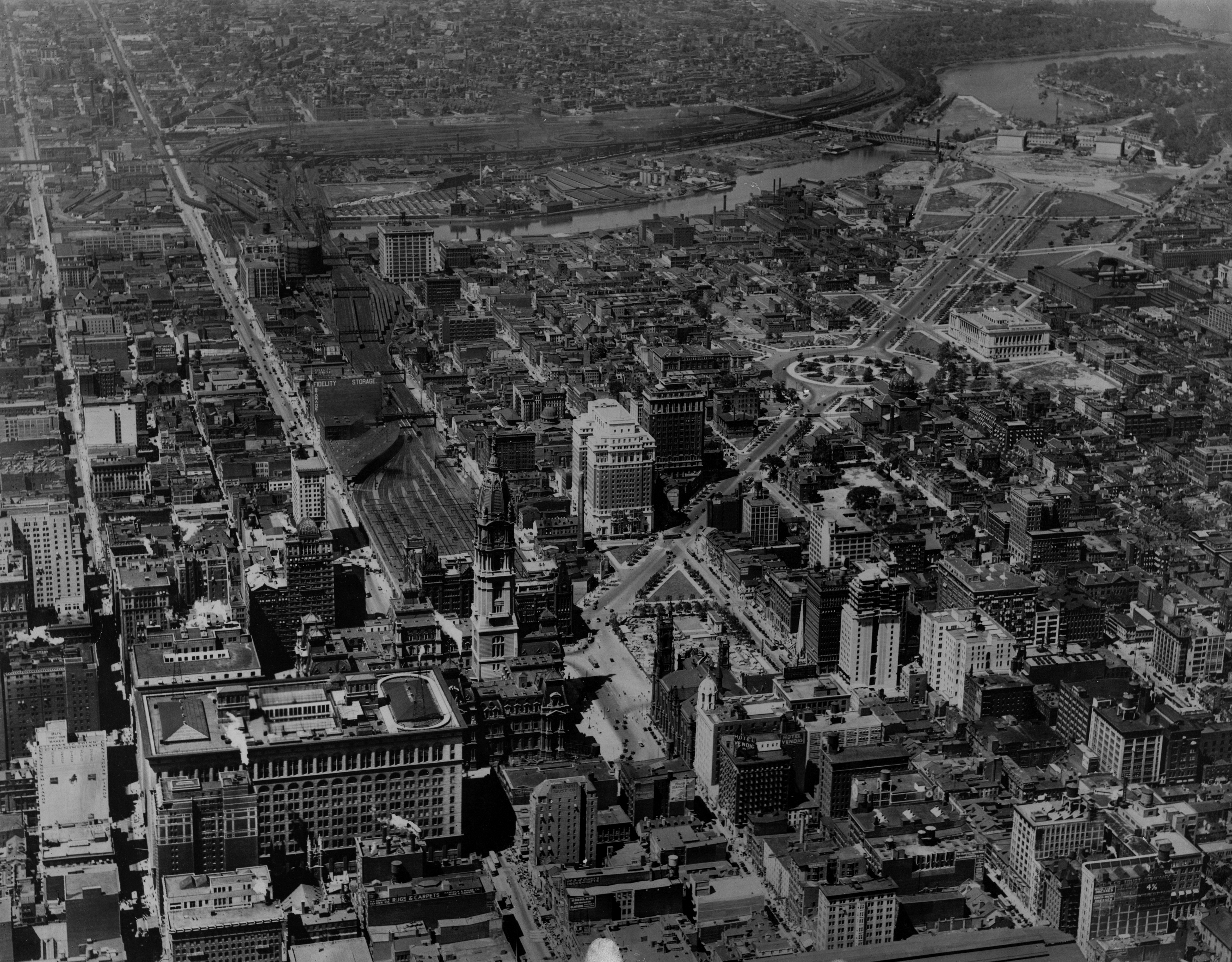
From Above: Looking West on Market Street, 1925

It’s been a long while since we visited Philadelphia From Above. So this week, in honor of the release of More Park, Less Way: An Action Plan to Increase Urban Vibrancy on the Benjamin Franklin Parkway, we’ll time travel to 1925 when the Parkway was being built to take in a different view of Philly from the sky.
This view from August 22, 1925, shows us what a wide swath of Philadelphia looked like during a major period of transformation. Look along the Parkway’s crisp diagonal to see the transition in progress: Construction on the Parkway itself wouldn’t be “completed” until 1926, but its form is very recognizable in this view. The Parkway’s great allée of London Plane trees are newly planted puffs here, likely struggling against the August heat. The Art Museum is still very much a work in progress, and its first section wouldn’t open until 1928. Swann Fountain was brand new, and here we can see it is spraying away in the middle of Logan Circle. Construction on the Free Library’s building was finished in spring of 1925, but it would not open until 1927. Still to come: Family Court, the Rodin Museum, and the Franklin Institute.
Next, follow the westward march of Market Street and the Pennsylvania Railroad’s tracks from Frank Furness’ Broad Street Station, over the river to the Schuylkill’s mighty rail yards. 30th Street Station isn’t yet under construction, but months before this picture was taken the Pennsylvania Railroad had struck a deal with the city to build the new station. If you look very carefully, you can see where the El pops out of the ground at 23rd Street to cross the river and continue its way above ground along Market Street. Look very closely and you can even see a tiny El train on that bridge.
In the foreground, the heart of Center City looks busy this morning. Along Market East, shoppers line the sidewalks and trolleys buzz along the street. Look closely and see what else you can spot.
This photograph is part of the Free Library’s Print and Picture Collection, and is used by PlanPhilly/Eyes on the Street with the express permission of Aerial Viewpoint, which owns these aerial images. For reproductions contact Aerial Viewpoint. To learn more background about these aerial photographs, head over here.
WHYY is your source for fact-based, in-depth journalism and information. As a nonprofit organization, we rely on financial support from readers like you. Please give today.


