FEMA releases long-awaited revisions to N.J. flood maps

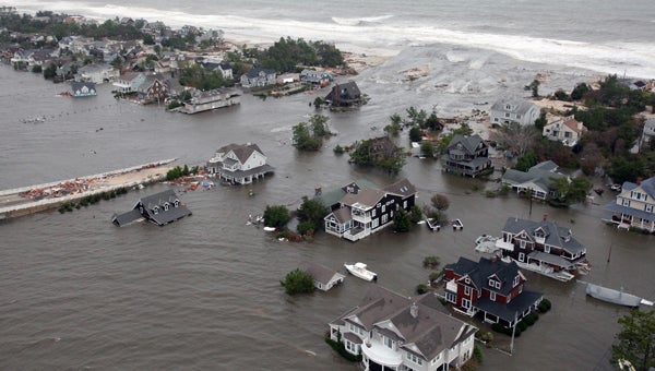
This Oct. 30, 2012 aerial photo provided by the U.S.Air Force shows flooding on the New Jersey shoreline during a search and rescue mission. (AP Photo/U.S. Air Force, Master Sgt. Mark C. Olsen)
Some homeowners along the Jersey Shore are finally getting answers from FEMA about their risk for flooding.
Over the weekend, FEMA began releasing an updated version of its flood insurance rate maps, which model the risk of flooding in a 100-year storm. Previous versions of the maps have been controversial, but many homeowners are awaiting these revisions with cautious optimism.
The updates cover Atlantic, Hudson, Monmouth, and Ocean Counties initially. Homeowners there can input their addresses on a FEMA website to see how the agency now classifies their risk for flooding.
Many homeowners hope this latest version of the maps will decrease the number of properties in velocity zones — areas in which FEMA modeling shows that 3-foot waves would hit structures during a 100-year storm. A version of the maps released in December included a dramatic expansion of V-zones compared with the existing maps, which were in many places decades old. The December maps were released in a hurry after the storm to aid rebuilding, but lacked some necessary data about how waves move across land.
Sue Belka lives in Bergen County and co-owns a second home in Brick with her mother. In December, they were alarmed to find themselves in a V-zone, “which [means] elevation requirements would cause me to raise my ranch home 10 foot in the air,” she says.
But Belka says the home is on a lagoon and waves didn’t hit her house during Sandy, so she’d like to see her risk downgraded in this new version of the maps.
“We were holding out high hopes for the release of the new maps,” says Belka. “But I’m hearing it didn’t do the people of New York much good, so I’m extremely concerned about that.”
FEMA released updated maps for New York City last week and Belka said she’s been reading social media posts from people who are still unhappy with their designation.
However, FEMA says New Jersey’s maps will significantly decrease the number of homes in V-zones and that the maps now include all the needed data.
A public review and comment period on the maps will begin in August before they are finalized toward the end of 2014.
WHYY is your source for fact-based, in-depth journalism and information. As a nonprofit organization, we rely on financial support from readers like you. Please give today.


