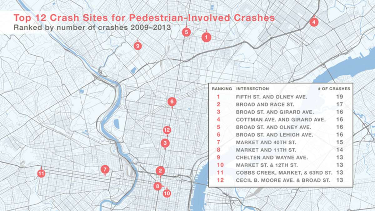
Bicycle Coalition joins PlanPhilly/Azavea in naming city’s most dangerous intersections for pedestrians [map]

By all appearances, N. Fifth St. and Olney Ave. resembles many of the city’s commercial corridors, with automobile and foot traffic meeting amid shops aplenty.
When either Cherelle Parker or Kevin Strickland replaces retiring Ninth District City Councilwoman Marian Tasco next year, they will hear about the intersection’s unfortunate distinction of being the city’s top crash site for “pedestrian involved crashes.”
Later this week, the Bicycle Coalition of Greater Philadelphia (BCGP) will formally release an official report pinpointing the most dangerous locations for pedestrians, broken down by specific City Council district, in an effort to garner support for the “Vision Zero” initiative.
What it all means
The initiative, which started in Sweden in 1997 and has since been embraced by several American cities including New York City and San Francisco, has a local “goal of reducing all traffic injuries and fatalities by 50 percent by 2020 — with the eventual goal of zero deaths.”
Stated another way, the goal is to bring traffic deaths and injuries down to zero for pedestrians, cyclists and drivers.
John Boyle, research director for the GPBC, began collecting the data last fall after Vision Zero was established as the coalition’s top priority in the mayoral campaign. It dovetails with the findings of a Azavea/PlanPhilly effort to map Philly’s most dangerous intersections for pedestrians.
“From 2009 to 2013, Philadelphia’s pedestrian fatalities increased over 15 percent at a time when automobile fatalities declined almost 15 percent,” the report reads. “While business and government officials and interests have made life safer inside motor vehicles, other street users, like cyclists and pedestrians, remain vulnerable.”
With mayoral support needed to make Vision Zero a Philadelphia reality, both Jim Kenney and Melissa Murray Bailey lent support for the effort when asked about it by NewsWorks’ NinetyNine blog.
BCGP Policy Coordinator Bob Previdi said that the group has already met with Council staffers, council candidates and mayoral candidates.
In those meetings, Kenney cited New York City Mayor Bill Di Blasio in saying he would, if elected, put a task force together comprised of internal city and state agencies (Streets, Health, Schools, Police, PennDOT and SEPTA) and stakeholders from neighborhoods including City Council, Previdi said.
“We are working with Council staff individually to identify major stakeholders in each neighborhood who can help initiate design changes to make streets safer,” he toldNewsWorks on Tuesday.
The 29-page report (PDF) includes “recommended strategies” to make Philadelphia streets safer and examines “pedestrian vulnerability” both nationally and localized to the city with data about problem locations and crash causes. It also includes a list of the “Top 52 Crash Sites Citywide 2009-2013.”
After Thursday’s official release, the BCGP will take data broken down specifically by district to councilmembers in an effort to turn support into the votes necessary to bring the initiative to Philadelphia.
WHYY is your source for fact-based, in-depth journalism and information. As a nonprofit organization, we rely on financial support from readers like you. Please give today.


