A community-based public-land study comes to an end, and trust is rebuilt in Eastwick
The intent was to remediate -- through a nine-month community-based study exploring what could and should be done with almost 200 acres of public land in the neighborhood
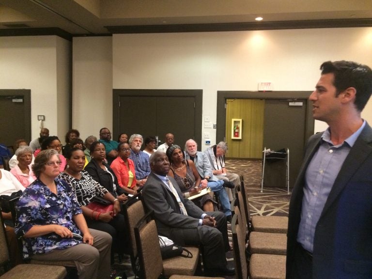
Philadelphia Redevelopment Authority director Greg Heller introducing the study. (Catalina Jaramillo/PlanPhilly)
This story originally appeared on PlanPhilly.
—
Healing wounds and recovering trust are not easy things to do. Yet that’s what Eastwick residents and the Philadelphia Redevelopment Authority, in coordination with other city agencies, set out to accomplish in January 2017 by sitting at the same table for the first time.
The intent was to remediate — through a nine-month community-based study exploring what could and should be done with almost 200 acres of public land in the neighborhood — the trauma caused by a 1950s-era urban-renewal plan that encompassed 2,500 acres and displaced more than 8,000 people. Or, as Eastwick community leader Terry Williams put it, to “rewrite the urban-renewal history with a new kind of urbanism and development.”
“I was skeptical about this process from the beginning,” Darien Thomas, a pastor and community leader, told a half-packed hotel ballroom in Eastwick. “I did not walk in the door believing that it was going to work. Because I represent the people from six generations who have been dumped on. And we have been promised things for year after year, after decade, after decade. So we were very, very skeptical.”
This Thursday night public meeting was the last of three such sessions and several conversations, workshops, and smaller gatherings that started in April 2017. At both previous public meetings, Thomas had loudly expressed his mistrust.
“But attending meetings, and listening to the process, and watching the procedure, that was really about building a village, not letting anybody [be] left behind, to make sure that we had education, housing, workforce development, recreation… all the things that were in the urban-renewal plan,” Thomas said. “…I know that we’re going somewhere. Because it’s been fair. I’ve been around long enough to understand that it has been a fair process.”

His remarks followed the opening words of Redevelopment Authority Executive Director Gregory Heller, who said that he was sure that “nobody is going to be 100 percent happy” with the study’s recommendations, but that he thought everybody was going to be “to be reasonably happy.”
The feasibility study, Heller emphasized, was just that — and not a community plan — to determine what the market could support, what the community wanted to see, and what was the responsible thing to do to avoid worsening the neighborhood’s flooding problem at three sites in Lower Eastwick owned by the Redevelopment Authority and the School District of Philadelphia.
“We heard from people who want to see development, we heard from people who want to see resources and workforce [development] and education for the community, we heard from people who don’t want us to build absolutely anything, anywhere,” Heller told the approximately 150 people attending Thursday night’s meeting. “We heard from people who care about flooding above all else; we heard from people who care about education and workforce above all else.”
This, Heller said, was not the end, but the beginning of a process to carry out what is in the feasibility study.
“We’re not going to take this and just put it in a drawer and close the drawer and walk away,” he said. “This is going to be the beginning of our road map to actually making something happen on these pieces of land that have been sitting here vacant for way, way, way too long.”
The recommendations for Lower Eastwick
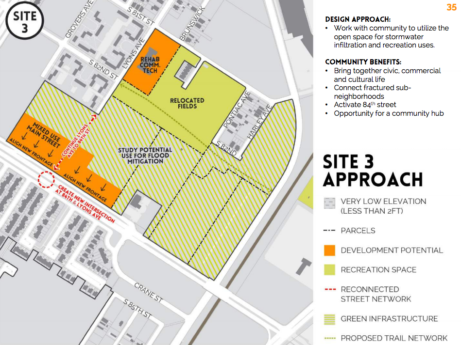
As PlanPhilly reported in June, the study led by Interface Studio recommends demolishing the former George Wharton Pepper Middle School, an icon of brutalist architecture built in 1971 on 84th Street between Mario Lanza and Lindbergh Boulevards. The former school sits at the lowest point in the neighborhood — at some places 2 feet below sea level — and frequently floods. Renovations to the school would cost more than $19 million, according to the study.
“A building should never have been built there, and it is absolutely irresponsible for us to continue to support a building in active use being in that location,” Heller said.
In the area encompassing the former Pepper Middle School site, as well as the former Communications Technology High School site and land along Mario Lanza Boulevard between 81st & 84th Streets, the study proposes developing two locations, leaving the others for flood mitigation.
The former Communications Technology High School, which is higher (it sits on the Federal Emergency Management Agency’s 500-year floodplain) and in better condition than the Pepper School, would be reused to fulfill the neighborhood’s desire for a community and education/training center.
In addition, a mixed-use “main street” would be developed along 84th street, with a lower building footprint than the Pepper School, to create a civic, commercial and cultural center. That speaks to the study’s vision of making Eastwick a “village in the city” where people can walk to get what they need and have places to meet.
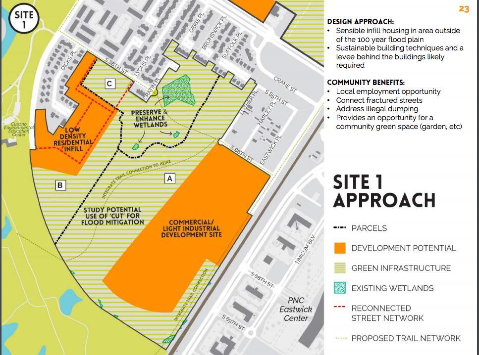
The study recommends dividing the biggest site — almost 130 acres bounded by the John Heinz National Wildlife Refuge, 86th Street, Lindbergh Boulevard, and Mario Lanza Boulevard — into three parcels. One has existing wetlands and should be used for flood mitigation. The second, closest to Lindbergh Boulevard and the only one in the 500-year floodplain, could be redeveloped as a low-density residential area, with 74 to 150 twin houses. The third parcel, closer to Mario Lanza Boulevard and along a rail line, could be used for light-industrial development by filling in the area above the 100-year floodplain.
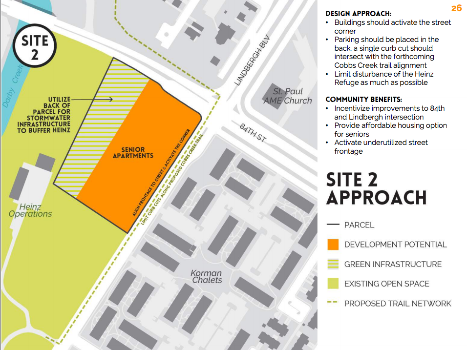
About six acres at the northwest corner of 84th Street and Lindbergh Boulevard could be used for affordable senior housing, another need expressed by the community during the process.
As a rule, Interface Studio principal Scott Page said, every area proposed for development is tied to a green area that should be prepared for stormwater management. And because every area that could be developed would need to be filled, they’re proposing to excavate and cut the surrounding areas to balance the site and avoid making flooding worse elsewhere.
Yet that’s not always the way things work out, Ross Pilling said after the meeting. He’s been a consultant for the Eastwick community since 2012, has 36 years’ experience in environmental consulting and real estate practice, and is a principal at Keystone Conservation Trust.
“The groundwater [in Eastwick] is very close to the surface, these are saturated soil conditions, so as soon as you excavate it’s just going to fill with water. You can’t create more water storage. And if you fill in other parts of the community, you are displacing floodwaters that have no place else to go, and it’s going to make things worse in the community,” Pilling said.
Landscape architect Scott Bishop, of Bishop Land Design, who developed the cut-and-fill and potential mitigation strategy, said in an interview that existing groundwater studies developed by the Environmental Protection Agency were used. But to make sure the cut-and-fill can be done safely, a hydrology study of the area is being recommended before any development takes place.
PRA’s Heller added that a developer also would be required to meet the city’s stormwater regulations and FEMA floodplain regulations, which would mean improvements must be made to the land so that it absorbs the first inch-and-a-half of rainwater.
“Almost always, if you are trying to remediate flooding issues, building is better than not building,” Heller said.
Joanne Dahme, a spokeswoman for the Philadelphia Water Department, said the regulations are not a flood-prevention strategy, however — they only allow a parcel to incrementally handle the volume of stormwater captured. “A redeveloped parcel leaves that portion of land in a better stormwater-management position post-development,” Dahme said in an email.
That would cover smaller kinds of storms, said Michael Nairn, a University of Pennsylvania urban-studies professor who has also worked with the Eastwick community since 2012, but “it does nothing to address the flooding issues in Eastwick, which floods because of its topographic position at the intersection of the tidal and downstream flows.”
More work lies ahead
After a 90-day public-comment period, Interface Studio will present a draft and then a final feasibility study. With that, the Redevelopment Authority will develop Request for Proposals for all the sites, to begin the process of selecting possible developers.
“Real estate development is a long process,” Heller said at the meeting. “I’m just warning everybody because I don’t want anybody thinking that we’re getting to the end of this plan and somebody is putting shovels in the ground tomorrow.
“But what I can promise you,” he said, “is that the Redevelopment Authority, the Planning Commission, and all our public-sector partners who are here at the table are going to stay here at the table and are committed to partnering with the community until we get through [and] all this land is redeveloped, and we can all move on from this redeveloping project, no matter how long that takes. All right?”
“Sounds good to me,” said Earl Wilson, president of Eastwick Friends and Neighbors Coalition, the organization that made the process possible back in 2012.
That feeling seemed to be shared by most in attendance.
“It was an excellent meeting,” said Leo Brundage, a longtime resident whose property constantly gets flooded.
“I think that it has a lot of potential, but it needs a lot of work,” said Tyrone Beverly, president of the community organization Eastwick United.
“I thought it went very well. I do like the plan, I know that we have a long way to go, but I’m energized,” said Margaret Cobb, one of the three neighborhood representatives on the study’s steering committee.
“I think it can work,” said resident Jill Minick.
“I think it’s a starting point, and it gives everybody a common platform to build on, so I think it’s a major step,” said Carolyn Moseley, president of the Eastwick Community Network.
Amy Laura Cahn, a former Public Interest Law Center lawyer who has been advocating for the Eastwick community since 2012, said she was really moved by Thomas’s speech at the beginning of Thursday’s meeting saying that he trusted this process and that it was fair.
“That’s what we’ve been asking in this iteration of the fight since 2012, and that’s what people have been asking for since the 1950s when they were kicked off their land — just to have a fair process,” said Cahn, who now lives in Boston and came in for the meeting. “And if the vision of the village is inspired and if there’s a way to make that happen, that would go a long way to writing the wrongs of urban renewal.”
Cahn said the most crucial thing in all the work in Eastwick has been building relationships and trust — and having the Redevelopment Authority acknowledging its own history.
“PRA has explicitly acknowledged its role in creating historic trauma and displacing people of color in the city,” she said. “And to be able to start there and to say we did this as an institution, and systemically, but we’re different people and we’re going to work together — that sets an amazing tone, and everybody bought in and worked really hard. And that’s visible.”
The next challenge, Cahn said, is to have the resources to make institutions accountable to the community, so that the community can control what happens next.
“This is just the beginning,” said Eastwick Friends and Neighbors Coalition’s Terry Williams. “This is just the beginning.”
WHYY is your source for fact-based, in-depth journalism and information. As a nonprofit organization, we rely on financial support from readers like you. Please give today.

