When atlases and GIS mapping collide

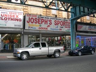
(Photo above) The field check found that the 1920s façade of The Circle Theatre can still be seen on floors above street level. Slidewhow at upper right: (Map Collection, Free Library of Philadelphia)
Aug. 5, 2009
By Alan Jaffe
For PlanPhilly
For a city symbolized by the Liberty Bell and renowned for its iconic Colonial architecture, only a tiny percentage of Philadelphia’s historic sites have been documented and evaluated.
Now, a marriage of old maps and new technology is producing what looks to be an important step in the first citywide survey of historic resources.
A joint effort of the Preservation Alliance for Greater Philadelphia, the Athenaeum of Philadelphia, and the Preservation Design Partnership is utilizing 19th century atlases and other period maps, GIS mapping, and digital technology in a unique experiment. The result may reveal the archaelogical layers of the city’s history from its early years to its current age.
This first phase of the Preservation Alliance’s multi-year project to create a preservation strategy for the city should provide the Planning Commission, area developers, communities and individuals with a tool that will help them make decisions on what is significant and worth saving.
A Sensible Approach
“What we tried to do is figure out how to do a survey of historic resources without it being incredibly expensive, cumbersome and time-consuming,” said John Gallery, executive director of the Preservation Alliance. “Is there some way in which you can simplify the process, as opposed to the way we would have done it in the old days, which was to have people drive up and down streets looking to see what they could find.”
Los Angeles is in the midst of such an effort now – with the help of $6 million in support from the Getty Foundation.
“A number of cities have been doing surveys. But most have been putting people on the streets, walking up and down, checking boxes on forms, or sometimes on handheld computers,” Gallery said. “No one that we know is using our approach.”
The approach is based on the premise that it is possible to predict what historic properties still exist, “so that you can go out and check those as opposed to looking at everything and trying to figure out what it is you’re interested in,” Gallery said. “And that is based on the assumption that different neighborhoods have historic significance that is fixed to a certain period of time.”
Then it would be a matter of finding a map from that period and comparing it to a contemporary map.
The Preservation Design Partnership, a preservation and architectural group that specializes in restoration, adaptive reuse, renovation and evaluation of buildings and sites, was pioneering the use of electronic surveys several years ago. In 2003, the state of Pennsylvania began requiring that site surveys be entered into a computer database, although its guidelines were “very quirky,” including a requirement that photos be submitted in black and white film and digitally, explained PDP partner Dominique Hawkins.
PDP created the first electronic survey in the state, which encompassed 400 properties in Tredyffrin Township. Using old but detailed atlases mainly drawn by the railroad companies that defined, subdivided and built the Main Line and its communities, PDP could locate potential historic districts within the township.
“We did a presentation on that project which John [Gallery] attended. He asked, ‘Can we do this in Philadelphia?’”
Their test project in the city focused on the Parkside neighborhood. With the assistance of a troop of Penn students, and the addition of digital photography, PDP was able to survey 160 parcels in Parkside in just six hours.
The Frankford Experiment
The next step would be a survey in a “scattered-site setting,” where historic sites might be found blocks apart throughout a larger section of the city.
“We decided that for the first round of surveys in Philadelphia, we would take the Frankford neighborhood because it’s very old, it’s historic, but surprisingly it’s never been surveyed, either for the National Register or for Philadelphia purposes,” explained Gallery. “And we were hearing that there were a lot of very early buildings – some from the 1700s – that were either being demolished or altered in strange ways.”
The Preservation Alliance asked the Athenaeum to use its regional digital imaging center to scan a series of atlas plates showing the streets and buildings of Frankford in the mid-1800s and subsequent decades.
The Athenaeum scanned 1,107 maps for the Alliance, including 850 just of Frankford. In a second phase, atlases that covered the entire city were scanned into the electronic system. The maps, ranging from the 1790s to 1959, were provided by the Philadelphia Free Library, the Philadelphia Historical Commission, the Historical Society of Frankford, and the Athenaeum.
The earliest of the large-scale atlases were published in the 1850s by Hexamer and Locher, said Bruce Laverty, curator of architecture at the Athenaeum. Each map covered six to seven blocks and showed property lines and building footprints. They were also color-coded to show the building materials utilized, and identified the presence of water mains and the uses of the industrial buildings. The maps had all this information because their production was underwritten by fire insurance companies interested in the fire risk of the geographic areas, Laverty explained.
Once the Frankford maps were scanned, PDP worked with the Historical Society of Frankford to determine where the potentially significant buildings still stood.
“We then geo-referenced the atlases,” said Hawkins. “We took blocks of buildings and electronically layered them under current city parcels. You can also layer on top of that aerial photos and create a sandwich of buildings, tracing the earliest footprint of the buildings over time.
“The idea is to use the atlases as starting points to find out where the concentrations of historic buildings are. Then you go into the field to verify conditions of the buildings – if there is any integrity left of the building as a piece of architecture,” Hawkins said. “The field check is pretty critical.”
Hits and Misses
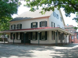
The first phase of the Frankford survey has focused on the institutional buildings: banks, businesses, houses of worship. “We found things like the Frankford Meeting House, and it’s exactly as it was” when it was built in the mid-18th century, Gallery said.
The same wasn’t true of The Circle Theatre, the only remaining example of atmospheric theaters in Philadelphia. The atmospheric theaters of the 1920s intended to transport audiences into an outdoor, exotic setting. Features included moonlit or starry skies painted on the ceiling, and murals of romantic landscapes with gardens and patios on the walls.
But The Circle is now a retail store, at least where the lobby used to be, Gallery said. “Up above the store, you see the remains of the historic façade. So you can say it’s there, but it no longer has its original historic integrity.”
The new surveying method has limitations. A survey of Colonial structures in Society Hill does not take into account significant homes or businesses built in the 1950s or 60s. “Modernist buildings appeared in many historic neighborhoods. We’re trying to figure out how to address that,” Gallery said. In addition to “looking at the neighborhoods as a geography, we’re also doing a couple of thematic historic statements” that will show, for example, where Modernist design appeared in Philadelphia.
But overall, the Frankford experiment seems to be a success. “It does look like it’s a tool that allows us to be more focused when we look at some of these neighborhoods,” Gallery said.
“There are lots of books about Philadelphia history, but there are no books about the physical development of the city. …. That’s what we’re trying to write. So you can say, ‘This is how Frankford developed, and the really important period in which it took shape was this year to this year.’ Then you can take the atlases from those periods and say, ‘What is still there?’ So as you plan for development, you can take that into consideration.
“We’re not saying that you try to list everything you discover on the Philadelphia Register of Historic Places,” but surveying in this way will determine the “really important” resources. “What are the things worth protecting, and is there a concentration of them sufficient that it should be considered a historic district? What we’re trying to produce is useful information of what’s there” for developers or communities, Gallery said. “Are there things worth protecting? Then you look at how to integrate it as opposed to demolish it.”
The Preservation Alliance also hopes the Planning Commission will find the historic mapping useful in creation of the new zoning code, and that they will together in deciding how the process will continue.
Originally the Alliance considered surveying city neighborhoods in chronological order, with the oldest first. Instead, the survey could blaze a trail for the new zoning. “Then they would have this data before they began to look at a neighborhood. Which would help them to say, ‘This is a commercial corridor, so that’s going to have one kind of zoning, and there are some industrial sites.’
“We think it would be useful to them. It would help them to quickly be able to see how historic resources relate to recent development,” Gallery said.
The Planning Commission is “intrigued” by the idea, and further discussion will explore the cooperative possibilities, Gallery said.
“What we’re trying to do is not just create interesting data. We’re trying to create information that would link to how other people would use it. Finding where those connections are is an important part of doing this.”
A byproduct of the mapping process has been a dramatic increase in visits to the website of the Greater Philadelphia Geohistory Network. In 2005, the Athenaeum received a Mellon grant to create the network and to begin scanning maps from the Free Library and its own collection. Visits to the site, www.philageohistory.org, have risen from 14,000 in the fiscal year ending July 2, 2008, to 37,000 in the year ending this past July 1. Page views grew from 81,000 to 451,000.
“The site is used by people trying to track their own properties, the histories of industrial sites, or for geneaology. Restoration professionals have been using the maps, too. The Philadelphia Historical Commission uses them on a regular basis as part of its historic designation process,” said Laverty, who is also director of the network project. “It has government, academic, as well as layman use.”

The Frankford Meeting House retains its 18th century appearance and historic integrity, the survey found.

The first floor of The Circle, however, does not retain its original historic integrity.
Contact the reporter at alanjaffe@mac.com
WHYY is your source for fact-based, in-depth journalism and information. As a nonprofit organization, we rely on financial support from readers like you. Please give today.


