Powerful Hurricane Michael makes history as it batters Florida Panhandle
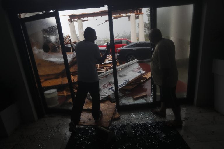
Hotel employees look at a canopy that just collapsed, as Hurricane Michael passes through in Panama City Beach, Fla., Wednesday, Oct. 10, 2018. (AP Photo/Gerald Herbert)
Hurricane Michael came ashore in the Florida Panhandle near Panama City Wednesday. Now a Category 3 storm with maximum sustained winds of 125 mph, it made landfall around midday at Category 4 strength, with winds of 155 mph at the time. That makes Michael the strongest hurricane to make landfall in the continental U.S. in more than a quarter-century, according to the National Hurricane Center.
Not since Hurricane Andrew has a storm clobbered the coast with the same ferocity as Michael slammed the stretch between Mexico Beach and Tyndall Air Force Base. It is also the first Category 4 storm to hit the Florida Panhandle since records were first kept in 1851, said NHC Director Ken Graham.
“This is definitely [and] unfortunately a historical and incredibly dangerous and life-threatening situation,” he added.
Now slightly diminished, the storm has moved its entire eyewall overland as it whips its way across the Southeastern U.S. In their update at 5 p.m. ET, forecasters said they expect southeastern Alabama and southwest Georgia to stand squarely in Michael’s path as it moves northeastward at a pace of 16 mph. And they expect that pace to pick up through the night into Thursday.
All the while, the NHC predicts that Michael “will continue to produce life-threatening hurricane-force winds well inland.”
“Everyone in the landfall area is reminded not to venture out into the relative calm of the eye, as hazardous winds will increase very quickly as the eye passes!” the hurricane center said.
Michael is expected to bring life-threatening flash floods and storm surges throughout coastal areas along the Gulf, from Pensacola along the coast to Tampa. The worst of it so far has been near Tyndall Air Force base, which has seen an inundation of between 5 to 10 feet.
As Michael stormed ashore, President Trump discussed the threat with Homeland Security Secretary Kirstjen Nielsen and FEMA Administrator Brock Long, during a meeting at the Oval Office.
Seated in front of charts depicting the storm, Trump said he had had a “long talk” about the hurricane with Florida Gov. Rick Scott, according to a pool news report. “It’s like a big tornado, a massive tornado,” Trump was quoted as saying.
Appearing at a White House event moments later, Trump said federal agencies are poised to help state emergency officials as they cope with the need for food and other aid.
“I just say, God bless everyone, because it’s going to be a rough one,” Trump said.
Not long after their conversation, Scott formally requested that Trump issue a major disaster declaration for the state. The request aims to expedite the process for obtaining federal aid. Scott said that as of Wednesday afternoon, Florida’s state agencies had already spent nearly $40 million on response costs alone.
Even before the storm made landfall, Florida officials said roughly 30,000 people had lost power because of the hurricane.
More than an hour before landfall, hurricane-force winds of above 75 mph were being reported in Apalachicola, Fla. Water quickly and steadily rose along the coast: A weather station in the small Gulf city reported flooding at 6.5 feet above ground level. High winds also forced officials to close several bridges in Bay County.
“We’ve issued our first ever Extreme Wind Warning,” the National Weather Service office in Tallahassee said in a tweet, as the storm approached. Noting that the warning means winds in “excess of 130 MPH are expected,” the agency urged people in the area to take shelter “immediately.”
Flooding started late Tuesday and early Wednesday in some areas; the NWS office in Tallahassee posted a photo of a building near Panacea, Fla., with water seeming to cover its lower third by around 6:30 a.m. local time.
With the storm powering toward the coast, the Weather Channel’s Mike Bettes said he and his crew were leaving Apalachicola, adding, “Better safe than sorry.”
The growth and continued low pressure led NHC scientist Eric Blake to call it “a near worst-case scenario for the Florida Panhandle.”
With the storm on Florida’s doorstep Wednesday morning, Scott told residents “it is not safe to travel across the Panhandle. [If you are in a coastal area], do not leave your house. The time to evacuate in coastal areas has come and gone.”
Those farther inland, Scott said, might be able to seek shelter if local officials say it is safe. Otherwise, residents should prepare to endure the storm at home.
“The worst thing you can do now is leave and put yourself and your family in danger,” Scott said.
There are currently 54 shelters open across the Panhandle and Big Bend areas, Scott said, with a population of nearly 7,000 people. He added that more than 1,000 search and rescue personnel will be deployed after the hurricane passes through.
“We have trucks loaded with tons of food, water and other critical supplies, ready to move in,” Scott said.
Areas along the coast and inland, miles from the expected landfall zone, will be at risk from this strong and large storm. Having made landfall with winds at nearly twice the minimum for hurricane status, Michael could remain a hurricane into early Thursday morning — a time when forecasters expect it to have plowed into southern Georgia.
Hundreds of miles of coastline remain under storm surge, hurricane and tropical storm warnings. Storm surge warnings continue, from the Okaloosa County-Walton County line to the Anclote River. A tropical storm warning reaches as far north as Duck, N.C., near the Virginia border.
Authorities have also warned of the possibility of isolated tornadoes throughout the night, from northern Florida up to South Carolina.
Looking ahead to the aftermath of the storm and the likely downed trees and utility lines, Graham said, “You have to stay away from those power lines. If you have trees down, it’s not the time to start learning how to use that chainsaw.”
People should also keep their generators outside, he added, to avoid being overcome by toxic fumes.
In Georgia, Gov. Nathan Deal expanded a state of emergency Wednesday to include 108 counties. Earlier in the day, he activated 1,500 Georgia National Guard troops to be ready for emergency response, though as yet no mandatory evacuation orders are in place in the state.
“This is a dangerous, dangerous hurricane and I urge those in Hurricane Michael’s forecasted path to be prepared, stand vigilant, and be ready to help their neighbors,” he said.
Meanwhile, South Carolina remains under state of emergency due to flooding the most recent massive storm to batter the state, Hurricane Florence.
“While we will not see the full force of Hurricane Michael the way Florida will, we could see gusty winds, rain, flash flooding and even tornadoes,” South Carolina’s emergency management director, Kim Stenson, warned Wednesday. “Over the next day, it will be vital for everyone to be prepared to act if told to do so by your local public safety officials.”
9(MDAzMzI1ODY3MDEyMzkzOTE3NjIxNDg3MQ001))
