Post-Irene: Looking to the morning after
-
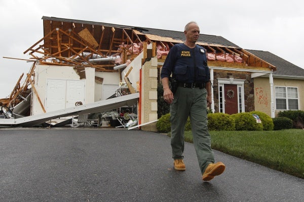
A member of the Delaware State Police walks away from a house that was heavily damaged by a possible tornado in Lewes, Del., Sunday, Aug. 28, 2011, after Hurricane Irene churned along the Delaware coast overnight. (AP Photo/Patrick Semansky)
-
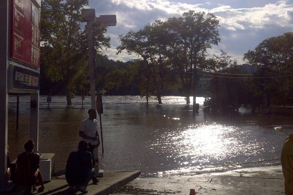
Sun hits the standing water on Kelly Drive in Philadelphia Sunday after stormed moved through the area. (Brian Hickey/For NewsWorks)
-
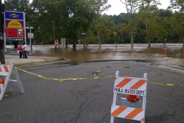
Flood waters creeped up towards a gas station in northwest Philadelphia Sunday. (Brian Hickey/For NewsWorks)
-
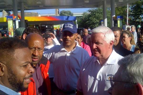
Pennsylvania Governor Tom Corbett stands alongside Philadelphia Mayor Michael Nutter after a press briefing Sunday in Philadelphia. (Brian Hickey/For NewsWorks)
-
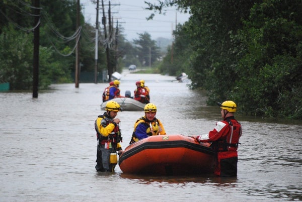
Teams went out in the swollen Christiana River Sunday looking for people who might be stranded from the flooding caused by Hurricane Irene. (John Jankowski/For Newsworks)
-
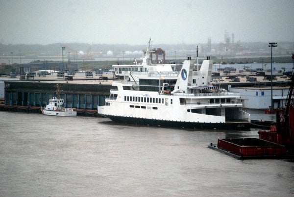
The predicted storm surge from Hurricane Irene forced the Cape May-Lewes ferry to head up the Delaware River and spend the night docked in Wilmington. (John Jankowski/for newsworks)
-
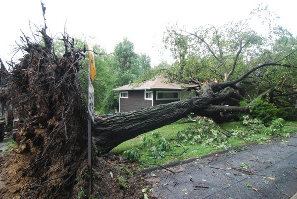
Heavy rains from Hurricane Irene uproot a tree in Edgemoor smashing into a home. (John Jankowski/For NewsWorks)
-
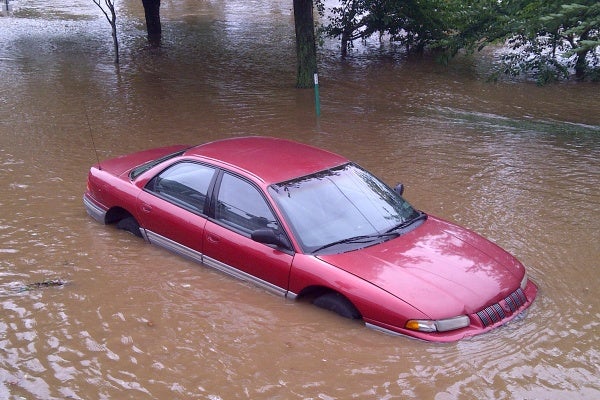
A car, stuck in flood water, was left abandoned without tages on East River Road. (Brian Hickey/For NewsWorks)
-
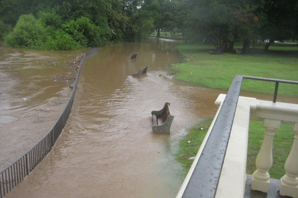
Hurricane Irene hits region.
-
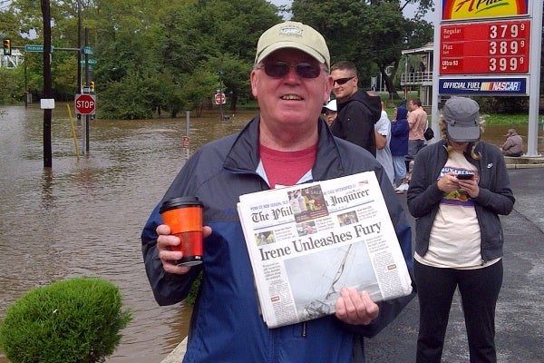
Sam Malloy, of East Falls, holds up a newspaper about Hurricane Irene. (Brian Hickey/For NewsWorks)
-
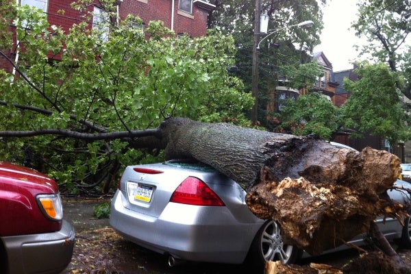
A large tree fell onto a car Saturday night as Hurricane Irene ripped through this Philadelphia nieghborhood, on the 4500 block of Osage Avenue. (John Meyers/For NewsWorks)
-
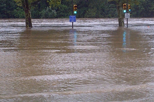
Flood waters crept up Midvale Avenue in northeast Philadelphia Sunday morning. (Brian Hickey/For NewsWorks)
-
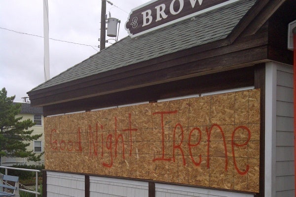
Some business owners in southern New Jersey got creative with the boards over their windows. (Tom MacDonald/For NewsWorks)
-
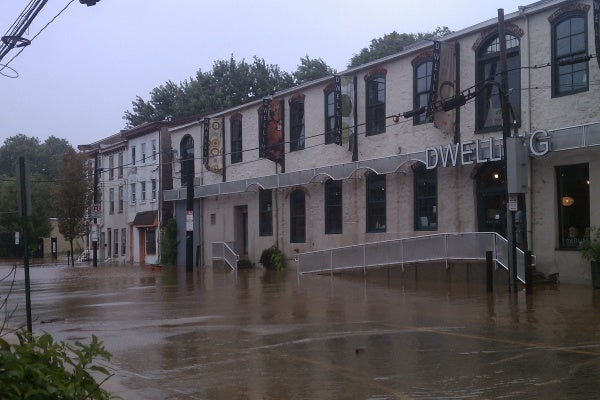
Flooding could be seen in Manayunk Sunday in front of this building at the intersection of Shurs and Main Street. (Megan Pinto/For NewsWorks)
-
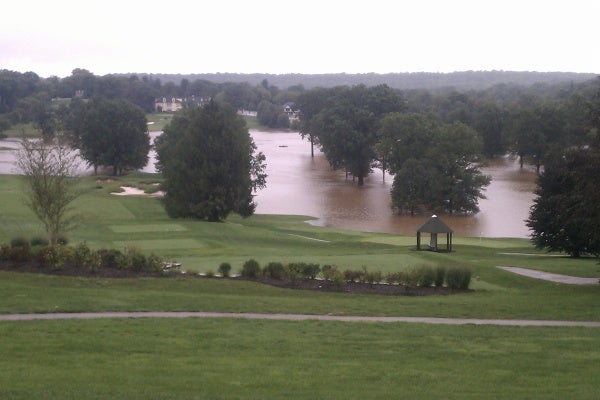
Water flooded portions of this Philadelphia golf course on Lafayette Hill Sunday. (Chris Sattulo/For NewsWorks)
-
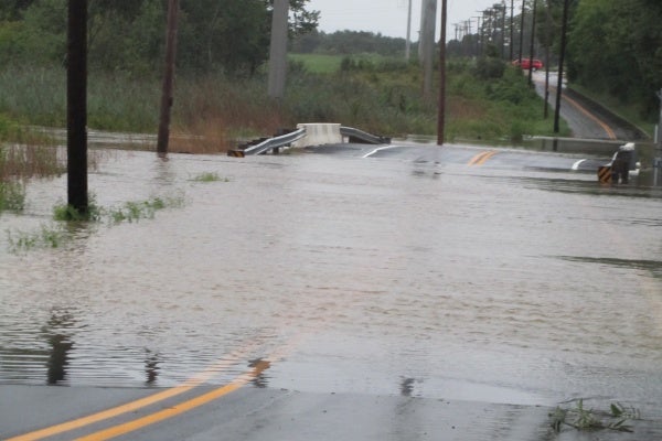
Dragon Run Creek over flows its banks and on to a local road near the Delaware City Refinery. (John Mussoni/for Newsworks)
-
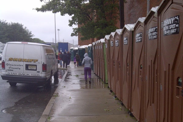
Things appeared calm outside one New Jersey shelter Sunday morning. (Tom MacDonald/For NewsWorks)
-
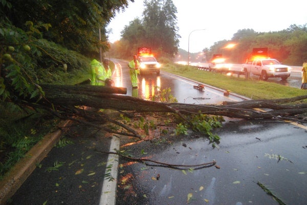
DelDOT crews work to remove a tree that had fallen at Route 202 southbound at the entrance to I-95 in Wilmington. (John Jankowski/for newsworks)
-

-

-

-

-

Although Irene didn’t pack the punch many feared, concerns now have turned to flooding, power outages and travel for the beginning of the workweek.
NewsWorks.org will continue to update you on Irene and its impacts on your workweek, travel and updated power outages around the area.
For another full slideshow of storm impact photos. click here.
Update, 8 a.m.
Several news organizations report Kelly Drive and Main Street in Manayunk have reopened after heavy flooding caused by Hurricane Irene.
Update, 7:30 a.m. (Monday)
PSE&G says at this time, there are approximately 265,000 PSE&G customers without power across New Jersey due to the Irene and flooding. At the same time, utility workers have already restored power to 240,000 customers impacted by the storm.
Currently, 6,000 employees are working to restore power, including out-of-state linemen and an additional 50 crews from Ohio and 540 tree contractors.
PSE&G says the majority of its customers should expect to have their power back within the next 48 hours, however, the company recommends residents prepare outages up to seven days.
Heavy rain and storm sruge from this weekend is also causing gas outages.
Update 9:18 p.m. (Sunday)
Irene, we hardly knew ye.
Here’s the postmortem on the storm from Tom Thunstrom of phillyweather.net, NewsWorks’ resident weather maven.
“Hurricane Irene definitely made an impact on the Delaware Valley, one that the region won’t forget any time soon from a rain, wind, and flood standpoint. The region picked up anywhere from three inches of rain (Reading) to as much as 13 inches (Sewell, N.J.), with many locations ultimately getting between four and eight. The rainfall lead to stream flooding and a record crest on the Assunpink in Trenton and the second highest crest on record on the Perkiomen Creek in Montgomery County. The rainfall capped a record month for rain in Philadelphia, with the region standing at over 19 inches of rain overall.”
Tom has more here, with all kinds of the charts beloved by weather aficionados.
Update 9:10 p.m.
If your morning commute usually takes you whizzing past Boathouse Row, you’re going to have to find a new way to get to work tomorrow morning.
A twilight confab in East Falls among Gov. Tom Corbett, Mayor Nutter, state Sen. Vincent Hughes and Councilman Curtis Jones, among others, produced that one clear result: Kelly Drive is NOT going to open for the morning rush hour.
Too much Schuylkill riverwater still communing with macadam, with an uncertain crest to occur overnight.
Update 8:29 p.m.
Good news for all Delaware commuters: DelDOT says the Indian River Inlet Bridge on Route 1, a vital connector for the First State, is reopened to traffic. DelDOT said its engineers used sonar technology to examine the inlet to make sure its bed hadn’t shifted or eroded in a way that jeopardized safety of the structure.
DelDOT will proceed with a more detailed inspection using professional divers on Tuesday of this week, as previously planned.
Update 8:26 p.m.
Blue Hens dry out eventually.
The University of Delaware postponed move-in day for its students on Saturday due to the hurricane.
The university has announced a new schedule: Students will begin moving into dorms on Tuesday for preparations for classes to begin on Thursday.
Update 8:15 p.m.
Along with a passel of state roads (see update below), PennDOT is keeping closed 38 bridges around the Philadelphia suburbs. Here’s the list.
Update 8:10 p.m.
For a ton of photos from throughout the day of flooding along the Schuylkill, click here.
Update 8 p.m.
Here’s SEPTA’s plan for helping – or not helping – you to get to work tomorrow.
Here’s what’s already running: Market-Frankford Line; Broad Street Line; City Transit Trolley lines; city bus routes (with detours); Rt.102 – Sharon Hill Trolley; suburban bus routes (with detours); CCT Paratransit.
The transit agency expects to have the following back in business on Monday, though with delays:
Regional Rail: Airport, Chestnut Hill East, Lansdale/Doylestown, Fox Chase, Media/Elwyn, Warminster, West Trenton, and Wilmington lines.
The Norristown High Speed Line (running with extra service) and Rt. 101 – Media Trolley.
The following lines are not expected to be restored in time for Monday’s morning rush due to flooding, downed trees and overhead wires and signal problems:
Regional Rail: Chestnut Hill West, Cynwyd, Norristown, Paoli/Thorndale, and Trenton lines.
Update 5:03 p.m.
Pennsylvania elected officials want President Obama to give the Keystone State some of the same succor he’s offered to other states that found themselves beneath Irene’s lash this weekend.
U.S. Rep. Mike Fitzpatrick, Republican from Bucks County, today wrote to President Obama echoing Gov. Tom Corbett’s request for a major disaster declaration for the Commonwealth.
A major disaster declaration will allow counties hit by the storm in eastern Pennsylvania to access emergency aid through the Stafford Disaster Relief and Emergency Assistance Act.
Fitzpatrick won’t be the only local congressman writing such letters, and issuing news releases about it. But he’s the first one to e-mail NewsWorks about it.
Update 4:32 p.m.
New Jersey Governor Chris Christie says he’s thankful so many Garden State residents and visitors heeded evacuation calls.
Christie says getting people out of harms way helped.
“The damage was not as severe as it was initially expected,” said Christie. “The fact that we were successful in evacuating over a million people from the most affected areas was a preemptive measure that I am confident saved lives.”
Christie says now New Jersey needs to focus on flooding. The Delaware, Ramapo, Raritan and Passaic Rivers are all expected to rise high above their usual levels.
Update 4:29 p.m.
Here’s PennDOT’s list of closed roads in the five-county Southeastern Pennsylvania district as of 4 p.m. on Sunday.
Update 4:28 p.m.
Tolls will resume at 6 a.m. tomorrow on the Garden State Parkway and the Atlantic City Expressway.
So how many gamblers just said to themselves: “I can head down tonight to the Boardwalk, to preposition myself for the opening of Atlantic City casinos at 8 a.m. tomorrow”?
Update 4:15 p.m.
The Red Cross reports the following shelters are now closed due to lack of need:
Darby Recreational Center – Darby
Cheltenham High School – Wyncote
Pottstown High School – Pottstown
Abraham Lincoln High School – Philadelphia
Roxborough High School – Philadelphia
Update 3:38 p.m.
Water levels have risen about two feet since noon, NewsWorks Manayunk editor Megan Pinto reports. For more on the situation in the ‘Yunk and East Falls, visit our community news page for the neighborhoods.
Upstream, in Conshohocken, another trendy riverfront area along the Schuylkill is also flooding, as the river creeps amid the office buildings and hotels that line the banks there.
Update 3:10 p.m.
Amtrak hasn’t had a lot of great days lately. The weekend of Irene definitely did not reverse the trend.
Our Carolyn Beeler caught up with some unhappy would-be rail passengers today at 30th St. Station. Her report:
The arrivals and departures board at the nearly empty 30th Street Station was a depressing sight today.
Washington. Richmond. Atlantic City. New York. All cancelled, to the annoyance of the few travelers here, including William Vann, who’s trying to get home to Newark:
“I’m very annoyed. When you want to go home, you want to go home!”
Agustin Cid evacuated his Atlantic City home Friday and wants to get home to see if it’s been flooded: “We’re trying to go back right now but the train station is closed, so I don’t know what we’re going to do!”
Cid and his family stayed at a Philadelphia hotel over the weekend: “We don’t have anywhere to go and we spent all our money already but uh, we’ll be fine.”
Amtrak officials say there are washouts and hundreds of trees down along lines in the Northeast.
So long distance service is unlikely to be restored on Monday.
To that last point, here’s the latest release from America’s passenger railroad:
“Amtrak crews continue to inspect and make repairs to the infrastructure along the Amtrak-owned Northeast Corridor, Springfield Line and Harrisburg Line in the aftermath of Hurricane Irene. Engineering teams are reporting areas of flooding, debris on tracks, and power issues.
As of 2 p.m., the following cancellations have been made for origination dates of Monday, Aug. 29: Auto Train Trains 52 and 53 (Sanford, Fla. – Lorton, Va.); Carolinian Trains 79 and 80 (New York – Charlotte, N.C.) canceled between New York and Raleigh only; trains will operate between Raleigh and Charlotte; Palmetto Trains 89 and 90 (New York – Savannah); Silver Star Trains 91 and 92 (New York -Tampa – Miami), canceled between New York and Jacksonville; trains will operate between Jacksonville and Miami Silver Meteor Trains 97 and 98 (New York – Miami).
The Piedmont Service (Raleigh – Charlotte, N.C) will operate as scheduled on Monday. In addition, the Carolinian will operate between Raleigh and Charlotte and the Silver Star will operate between Jacksonville and Miami on Monday, Aug. 29.
Additional cancellations are expected. Passengers who have paid for travel on canceled trains can contact Amtrak to receive refunds without fee or penalty or can rebook for future travel. If tickets have not yet printed, the refund/rebook can be done on Amtrak.com or the new and free Amtrak iPhone app.”
Hey, at least they have an iPhone app. And they do regret the inconvenience.
Update 2:13 p.m.
In this moment of flash mobs and recreation center shootings, Mayor Nutter has used some choice terms to describe some citizens of Philadelphia recently, including “knuckleheads” and other terms less printable on family Web sites.
But today at his morning post-Irene news conference, he laid a big, sloppy kiss on the cheek of his city, as he assessed how well Philadelphia coped with the storm:
“The most important participants actually are the citizens of this city. They did a spectacular job; they took our advice. They heeded the warnings. They did virutally everything we asked them to do, and for that we’re very very appreciative because without their support, without their help,and without their engagement there really could have been some significant tragedies here.”
We’re guessing the mayor probably was excluding from the compliment the two guys the police arrested this morning for rowing down Main Street in Manayunk, or the looters at the collapsed Chinese restaurant in North Philadelphia (as reported by our Elizabeth Fiedler.)
Update 1:55 p.m.
From WHYY/NewsWorks Delaware bureau, Shirley Min reports:
The state of emergency issued by Wilmington Mayor James Baker Friday afternoon remains in effect.
The city says this enables themMayor to take necessary actions so the city can continue providing emergency services to Wilmington residents.
The evacuation order for residents in southeast Wilmington has been lifted, so residents may return to their homes and businesses. The city says it will provide transportation home for residents in the evacuation zone who were sheltered at William Penn High School.
If the damage is too great and their properties are uninhabitable, they have the option of returning to William Penn High School for shelter. Residents in the southeast evacuation area who need transportation back to the shelter at William Penn should call 302-576-2489 no later than 6 p.m. this evening.
Update 1:40 p.m.
The Princeton firefighter is not dead, but alive in critical condition.
A spokesperson for New Jersey Gov. Chris Christie said, at a news conference this afternoon, the governor relayed inaccurate information about the firefighter injured during a water rescue today.
Update 1:11 p.m.
A second storm-related death has been reported in New Jersey. A firefighter died of injuries suffered while on a water rescue mission in Princeton. No further details are available. Gov. Chris Christie announced the death during a just-completed news conference.
WHYY’s Phil Gregory reports these other points from Christie’s news conference:
The Garden State Parkway just reopened southbound, but it remains closed for the time being in all directions between exits 98 and 91–Wall and Brick townships.
650,000 customers are still without power in New Jersey. There may be more, as wind gusts are still high and trees may still be knocked over.
Flooding has occured along the Delaware River, with more severe flooding expecting around Ramapo and Passaic rivers further up north.
Atlantic City Casinos are expected to reopen tomorrow morning.
Christie’s going on a helicopter tour this afternoon to assess damage, but he expressed confidence that the damage is not as severe as anticipated.
Update 1 p.m.
From Bucks Couny, Eugene Sonn, WHYY’s audio news director, files this report:
Neshaminy Creek in Bucks County appears to be cresting more than 10 feet above flood stage.
The high water has blocked traffic on Route 413, the main road connecting Langhorne and Newtown.
Louise Foster’s house is right on the creek in Langhorne and is the last one you can reach by car from that side. She says this is the worst flooding since Tropical Storm Floyd in 1999.
“It doesn’t bother me,” said Foster. “My daughter was worried about me, my sister was worried, but. My brother just called me. I said, ‘No, I’m fine.'”
Foster says she still has power and a dry basement.
While the Neshaminy is expected to slowly recede Sunday, Delaware River towns in Bucks County are bracing for the big river to crest on Monday.
Update 12:50 p.m.
A clarification from Philadelphia International Airport: In essence, when the airport said it would “resume operations” at 4 p.m., it didn’t mean that in the sense any normal person would understand it to imply. No planes will leave the airport until tomorrow, it turns out, though a few might manage to land today.
Here’s the airport’s statement:
“Philadelphia International Airport will reopen at 4:00 p.m. today as previously reported. However, all of our airlines have confirmed they have no departures scheduled from Philadelphia International Airport today and, as such, we continue to ask that travelers not come to the airport today.
There will be very limited arrival activity after 4:00 pm today as the airlines get ready for Monday, August 29, when the plan is to resume normal operations.”
The airport recommends people with tickets for flights contact their airline for more information.
Update 12:25 p.m.
SEPTA will begin running airport shuttle bus service at 1 p.m. Buses will run hourly between 15th and Market Streets in Center City and the Airport. This service will continue through the end of service on Sunday.
The airport is scheduled to resume operations at 4 p.m.
Update 12:08 p.m.
The Schuylkill is rising fast. NewsWorks’ Manayunk editor Megan Pinto reports the Canoe Club in East Falls is flooded, and Main Street in Manayunk is under water for most of its length.
From the Art Museum and Boathouse Row, WHYY’s Maiken Scott filed this report:
Margaret Meigs is a member of University Barge club. She’s working along fellow volunteers to get the boats out of the club house and hoist them onto racks on the lawn:
“They are down low in our bays and the water is coming up to a level unprecedented; it’s never been as high as this since our boat house was built back in 1871, so we need to get boats up so they won’t be floating around as the river water comes in to our boat house.”
Meigs says the boat houses are designed to handle some flooding, and nothing other than boats is stored on the first floor. The Schuylkill is also lapping against the first story of the restaurant at Fairmount Water Works.
Update 11:52 a.m.
New Jersey has its first fatality from Irene.
State police reported a few minutes ago that the dead body of a woman was found in a Honda Accord on Route 40 near King’s Highway in Pilesgrove Township, Salem County.
The woman’s name has not yet been released to the public.
Police said a friend of the woman’s called emergency services to report she’d called him him, saying she was stranded in a vehicle in rising water. Police went to the area, rescued one stranded woman motorist, took her to the hospital, then returned to the area to find the Accord with the dead body inside.
Update, 11:10 a.m.
WHYY’s Tom MacDonald this morning swung by the emergency shelter set up at Rowan University in Glassboro to handle evacuees from Jersey Shore towns.
He said the 1,200 folks there were muddling through, grateful to be away from Irene but eager to hear the word that they could return to their homes. The latest word is that won’t be until tomorrow at the earliest.
Said one displaced resident from Atlantic CIty: “It’s really rough. But we’re blessed. But we’re just trying to pull through with the storm and everything – and hoping to get back to the city and it’ll be OK.”
Jose Carlo is also from Atlantic City: “Everyone just really wants to go home right now. We thought we’d be going home today, but now we’ll be going home tomorrow afternoon.”
Update, 10:55 a.m.
SEPTA is struggling back to life. City subways, the Market-Frankford El, all trolley lines and many buses are operating. About half of suburban bus routes are running, but with many detours.
The problem child is Regional Rail, still out of service due to flooding and downed treees. Also still suspended are the Norristown High Speed Line (Route 100) and the Media and Sharon Hill Trolley Lines (101/102), will remain suspende.
Main Street, Manayunk, and Kelly Drive through East Falls are flooded and closed. Listen for a report from NewsWorks’ Manayunk/East Falls editor, Megan Pinto, on WHYY at 11:04
There’s heavy flooding on Darby Creek in Delaware County.
Update, 10:15 a.m. Things are starting to get back to normal in Philadelphia today after Irene made it through our area. Mayor Nutter says the city will lift its emergency declaration at noon today, but city officials will continue to identify and catalog damage throughout the city.
Thus far, the Mayor reports trees down and flooding in some parts of the city. There have been reports of buildings collapsing – but everyone has been accounted for and is okay. There have been no storm related injures or deaths, according to Mayor Nutter.
Parts of the SEPTA system are also scheduled to return to service this morning. The Mayor says the Broad Street and the Market/Frankford lines are ready to go.
As of now, there is no regional rail service available.
As for the airport, Mayor Nutter says Philadelphia International Airport will work to get flights rescheduled or in the air at 4 p.m.
City officials urge you to still be aware of the weather and wind gusts, however, local forecasters have said it appears the worst of the storm is out of our area.
Update, 9:45 a.m. NewsWorks reporters are out surveying several areas in Philadelphia and in parts of New Jersey and Delaware. Our reporters are sending us pictures that show heavy flooding on some roads in Philadlephia and parts of New Jersey, but thus far, no significant damage, after Hurricane Irene made it through the area last night.
Some pictures show flooding on roads, others show downed trees. The most severe damage we’ve seen thus far is a picture of a tree that fell onto a car on the 4500 block of Osage Road in Philadlephia. (You can see these pictures in the photo gallery above)
Update 7 a.m. From NewsWorks weather blogger Tom Thunstrom of phillyweather.net:
The center of Irene continues to work north-northeast, with its strongest winds offshore and to the east of the center of the low. It is tracking towards Long Beach Island; it has just about cleared the barrier islands of New Jersey as it moves towards a final landfall just east of New York City. The transition from a hurricane to a hybrid system has been taking place over the last several hours as the eyewall deteriorated and signs of a frontal boundary are showing up on radar just east of the center of the storm. This is the first signs of the storm transitioning from a tropical to non-tropical system. It doesn’t mean much different locally in terms of final wind impact; it will be a windy time of it for the region for much of the day. However, rainfall should taper off quickly in mid-morning as the low passes by to our east along and just offshore of the Jersey coast.
Anecdote – The LGBT journalists convention this weekend at the Loew’s Hotel in Center City had a lot of no-shows thanks to Irene, but those who were there gathered after the final formal event of the evening to drink, talk and watch hurricane news. At one point, Don Lemon of CNN, one of the keynote speakers for the event, walked into the room. Eyes turned to him, then sheepishly back to the TV set in the room – which was tuned to MSNBC.
Update, 5:46 a.m. President Obama this morning signed a Delaware Emergency Declaration and ordered federal aid to help state and local efforts after Hurricane Irene ripped through the area Saturday. The President’s action authorizes the Department of Homeland Security, Federal Emergency Management Agency to coordinate all disaster relief efforts.
Update, 5:00 a.m. A Philadelphia International Airport spokesperson told Fox 29 Sunday morning the airport would remain closed through the afternoon as officials continue to monitor Hurricane Irene. Spokesperson Victoria Lupica says fewer than 30 people were stuck at the airport as the hurricane made its way through our area.
Update, 3:33 a.m. Irene is just off the coast of Cape May. Rain continues to drench the region, with flooding and widespread power outages reported. Winds are expected to intensify further.
Update, 2:00 a.m. From phillyWeather.net: Irene’s eye is now approaching Ocean City, MD and continuing to work northeast. The core of the storm is about to work into coastal Delaware and into Cape May, featuring wind gusts to near 80 mph as Irene’s center of lowest pressure lifts up the coast over the next several hours. The lull that you experienced earlier is shifting north into Central Jersey as another round of wind/rain return to Philadelphia — rainfall is picking up and will get heavier. However, the brunt of the storm over the next few hours will shift to the Delaware Beaches and the Shore. Winds locally will remain gusty but our strongest winds may still arrive when the eye passes east of us between 7 and 10 AM through the region. Wind gusts around DC reached 58 mph during the Midnight hour.
Update, 1:00 a.m. From NewsWorks’ weather blogger, Tom Thunstrom of phillyWeather.net: The “lull” that worked through Philadelphia is quickly ending, shifting into the northwest burbs and being replaced by another round of rain and wind sliding back into the city. This band is not, as of now, as bad for Philadelphia as the last round that is currently pivoting across the northern burbs and Central New Jersey. However, the shell of the eye of Irene is at the bottom of the radar below, located just offshore of the Virginia/Maryland border and sliding north-northeast. It’s generally on track to stay along the coast for the rest of the night.
WHYY is your source for fact-based, in-depth journalism and information. As a nonprofit organization, we rely on financial support from readers like you. Please give today.


