Winter Storm Warning in effect for all but Cape May County; power outages possible

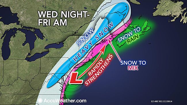
A strong Nor’easter will move through the area Wednesday night into Thursday, possibly dumping over a foot of snow in portions of the area, forecasters say.
Energy from the Pacific Northwest and the Gulf of Mexico region will collide to form the storm off the southeastern coast that will then track up the Eastern seaboard, according to John Homenuk, lead forecaster at New York Metro Weather.
A Winter Storm Warning covers all but Cape May County, where a Winter Weather Advisory is in effect.
Snowfall amounts range from 10-14″ in a band extending from northwest New Jersey through the western Philadelphia suburbs as well as in most of northeast New Jersey, according to the latest National Weather Service forecast. Snowfall amounts become progressively less to the southeast, with the smallest accumulation in Cape May County.
Forecasters expect a heavier, wetter snow, which could lead to power outages.
“And though icing due to freezing rain not expected to be an issue, this will be a heavier, wetter snow, more prone to stick,” tweeted Gary Szatkowski, head meteorologist at the National Weather Service in Mount Holly, NJ. “If the snow is sticking to tree limbs and power lines, and the winds pick up, increased loading means more tree limbs coming down. And that means greater potential for power outages. Will be looking at this more closely as forecasts are updated through the day.”
There are no significant changes in the forecast since the issuance of the National Weather Service’s Tuesday afternoon briefing. Here are the specifics from that document:
Timing: Snowfall starts Wednesday evening and continues into Thursday. Heaviest snow will fall during the late overnight hours into Thursday morning.
Accumulations: The heaviest snowfall will be to the northwest of the I-95 corridor. However, a large part of the area will see 6+ inches of snow. Snowfall rates of one to two inches per hour are possible late Wednesday night and early Thursday morning. This will be a wet, heavy snow that will cling to trees and wires. Freezing rain no longer seems to pose a major threat during this event. However, there could still be some sleet with this event.
Travel impacts: Current storm timing still indicates the Wednesday afternoon/evening commute should be OK since precipitation is expected to start after 8 p.m. Wednesday. However, major travel impacts can be expected for both the Thursday morning and Thursday evening commute. Temperatures on Thursday will range from the upper 20s far north to mid 30s south. Cold, but not bitter cold. This may help with road conditions.
Coastal flooding: Minor coastal flooding is likely along the Atlantic coast and in the Delaware Bay and Raritan Bay. Moderate coastal flooding remains a possibility depending on the eventual path of the storm. High tides to watch are both high tides on Thursday and the morning high tide on Friday. Heavy rainfall near the Atlantic coast may worsen the coastal flooding impacts.
But forecasters stress in the briefing that the forecast remains volatile, “as small changes in storm track and/or intensity could result in a significant change in the impacts.”
Either way, Thursday looks like a day to stay put.
“Heavy snow, rain, and winds along the coast are expected to make Thursday a day where you will be better off just staying inside,” Homenuk said.
Click here for the latest snowfall accumulation forecast for most of New Jersey, eastern Pennsylvania, and Delaware. For northeast New Jersey, click here.
WHYY is your source for fact-based, in-depth journalism and information. As a nonprofit organization, we rely on financial support from readers like you. Please give today.

