Why beaches are usually cooler during heat wave afternoons
It’s courtesy of the sea breeze effect.

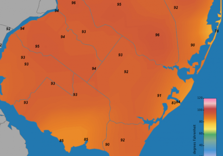
It's cooler at the coast at 1:30 p.m. on July 2, 2018. (Image: Rutgers' NJ Weather Climate Network)
With the first heat wave of the summer upon New Jersey, the state’s beaches are teeming with people seeking relief.
If you’re a longtime radio listener, the words “cooler at the coast” probably ring a bell, and the temperature differences between the shore and inland can be extreme at times.
During the summer, beachgoers along the oceanfront can enjoy temperatures in the 70s or 80s while just inland, everyone is baking in the 90s.
On Sunday afternoon, temperatures surged to around 100 degrees throughout inland portions of coastal counties while beaches remained around the lower to middle 80s.
It’s courtesy of the sea breeze effect. National Weather Service meteorologist Walter Drag explains that it occurs due to the difference between the warm air over land and cool air hovering over the ocean.
“What you have is, when wind increases during the day, cooler air is heavier, and it’s drawn inland, replacing the warmer air that’s rising. Winds can begin westerly, then when the land heads up, turns southwesterly and then southerly,” he told WHYY in 2017, stating that the air along the coastal areas becomes cool due to ocean air getting pushed along the coast and inland.
Sometimes, Drag says, if the offshore winds are weak, the sea breeze can dominate and push as far west as the I-95 corridor or even Philadelphia. The stronger the westerly or northwesterly winds, the less sea breeze inward force.
Ocean temperatures are slow to warm and don’t generally reach the 70s until August, so that’s why the sea breeze effect is so dominant during late summer, Drag said.
WHYY is your source for fact-based, in-depth journalism and information. As a nonprofit organization, we rely on financial support from readers like you. Please give today.


