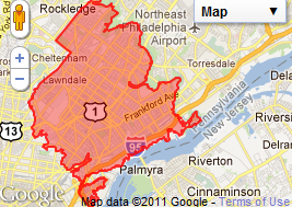
What parts of Northeast Philadelphia are most likely to flood?

Philadelphia has an official hurricane warning ahead of Hurricane Irene, and residents throughout the region are scrambling to get prepared.
But one of the biggest questions is how vulnerable are you in the Northeast? Fortunately, there is some help.
First, a group of local web developers created Disaster Mapper, which allows users to type in a Philadelphia address and find all nearby threats, like hazardous materials and, yes, flood plain information. Give it a try.
Get more information below.
More broadly, a City of Philadelphia press release [PDF] highlighted the many flood prone parts of the city, including a few in the Northeast:
- All city creeks and streams including Pennypack, Poquessing, Tacony, Frankford and Wissahickon Creeks;
- All along the Delaware River, first along Delaware Ave and Ben Franklin Bridge but extending along its waters north and south
- Specifically where Linden Avenue meets the Delaware
- Find a PDF map here of flood prone areas through Philadelphia
Other information from the same release [PDF]:
“With the current forecast track, Philadelphia can expect the following:”
- Rainfall exceeding 7″, which would send all streams, creeks, and the Schuylkill River into flood stage. Flash flooding in streets and low lying areas could also be expected. Tidal flooding along the Delaware River is also possible.
- Sustained winds of 40-50 mph with gusts to 60 mph or higher. This level of winds could cause downed trees, power outages, and other infrastructure disruption.
- To date, August has been the 2nd rainiest month in Philadelphia’s history. So rainfall from Irene could cause severe flooding in the city.
WHYY is your source for fact-based, in-depth journalism and information. As a nonprofit organization, we rely on financial support from readers like you. Please give today.


