

Tornado warning for Delaware, Chester Counties
A Tornado Warning has been issued for parts of Delaware and Chester counties through 6:15 p.m. New Castle County, Delaware is also in the warning. TAKE SHELTER.
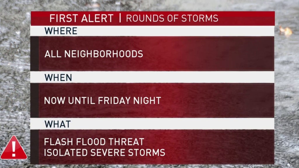
Be weather aware for the threat of flooding Friday as storms hit the region.
A FIRST ALERT has been issued for the entire region through Friday night, due to the threat of several rounds of scattered storms with the potential to bring pockets of heavy rain which may trigger flooding. With high-totals recent rains, the ground is saturated throughout the Delaware Valley. Rain amounts of just 1 inch may be enough to trigger problems in some neighborhoods.
Overnight into Friday, the next round of storms entered the area. These storms were scattered but a few packed a punch with thunder, lightning and heavy downpours.
This potential continues through Friday morning. In Skippack, Montgomery County, an inch of rain fell in less than an hour leading to street flooding by mid-morning.
Later in the afternoon, the next round of storms is expected. These storms are likely to begin in northern neighborhoods like the Lehigh Valley and Berks County, where there were already thunderstorm warnings in the late morning. They will slide south through the Pennsylvania suburbs, Philadelphia and Wilmington. Again, these storms don’t need to carry much rain to cause localized flooding and creek swelling. The storms should weaken as they slide south into southern Delaware and South Jersey, and will exit overnight.
Thanks to clouds, rain and a northeast wind, temperatures will remain milder and barely get into the 80s Friday.
Saturday clouds may linger, and Sunday sunshine will return. An isolated storm is possible Saturday, but the weekend is looking mostly dry. Even Monday looks dry and partly sunny.
Fri: Mostly cloudy, scattered showers and a chance of thundershowers. High around 80.
Sat: Partly sunny. a slight chance of showers. High in the mid 80s.
Sun: Sunny and hot. High around 90.
Mon: Partly cloudy and hot. High in the low 90s.
Tue: Partly cloudy with scattered storms. High in the low 90s.
Stick with the NBC10 First Alert Weather Team on air throughout the day and download the app to stay ahead of the storm even if you lose power.
WHYY is your source for fact-based, in-depth journalism and information. As a nonprofit organization, we rely on financial support from readers like you. Please give today.

Heavy rain pummels the East Coast and sparks isolated flash flooding
Airports in Philadelphia, New Jersey and New York reported flight delays and cancellations, and Amtrak officials said high water stopped trains between Philly and Wilmington.
10 months ago

Tornado touched down in South Jersey during severe storms: NWS
The twister was rated as an EF-0, with max winds of 65 mph to 75 mph.
1 year ago

2 tornadoes confirmed in New Jersey after Thursday’s storm
One of the twisters touched down near the intersection of Ridge Road, Whites Bogs Road, and Range Road in the Browns Mills section of Pemberton Township in Burlington County.
3 years ago