

Sussex County considers regulations to preserve Delaware forests in the face of development
The law would protect a percentage of trees on a given property from being cleared. Some residents support adopting the law, with a few reservations.
Listen 1:03
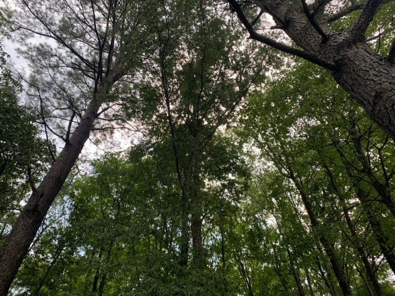
A forested area off of Neptune Road in Milton, Del. (Sarina Grossi/WHYY)
What are journalists missing from the state of Delaware? What would you most like WHYY News to cover? Let us know.
Sussex County could soon adopt regulations that would help protect forests in the area. As of now, the county has limited forest protection laws, despite it having the most forestland in Delaware.
The law was initially proposed at the County Council’s April 21 meeting, following recommendations from the Sussex County Land Use Reform Working Group. The group was established by the council in 2025 to review land use trends and suggest changes to zoning codes and the Comprehensive Land Use Plan.
At a public hearing earlier this month, the County Council voted unanimously to defer action on the law for further consideration.
The proposed ordinance would require developments located in “growth areas” of the county to preserve at least 30% of pre-existing forest; for the county’s “rural areas,” that requirement is 50%. Growth and rural areas are designated by Sussex County’s Comprehensive Plan and Future Land Use Map.
Requirements do not include the perimeter buffers of developments, or the property line, on which the county has already established protection and planting regulations.
Related Content
3 decades in the making, Delaware lawmakers pass measure to protect state’s wetlands
The legislation will create a tiered permitting system for development based on how critical a nontidal wetland is.
2 months ago
Forest mitigation
The ordinance states that a developer who proposes forest removal is required to prepare a mitigation plan. In growth areas, any cleared forest area would be required to replant two times the area that was cleared. In rural areas, that number is 2.5 times the forest area cleared.
“If there’s 10 acres of forest and three acres have to be protected, but for whatever reason the developer wants to clear all the forest, the developer will be, again, required to protect three acres because it’s in a growth area,” said Assistant County Attorney Vincent Robertson during a presentation. “Six acres would have to be reforested.”
There were concerns from county residents regarding this section of the ordinance. Resident Patricia Marney said in a written statement to the council that the replanting was “insufficient.”
“Young saplings take decades to mature and cannot match the ecological function or flood absorption capacity of an established, multi-layered forest canopy,” she said.
Chad Carter, the president of the Delaware Board of Landscape Architects, said that although he supported the ordinance, he was concerned about its language being too vague with planting requirements.
“As written, the provision could be interpreted to establish the minimum planting rate of 100 trees per acre applicable to all development sites rather than specifically to the afforestation or mitigation areas,” Carter said at the hearing.
He recommended that county staff clarify whether the requirement applies to the replantings to make sure developers have a consistent interpretation of the ordinance. Carter said the perimeter buffer area should also be removed from the estimated amount of forested land on a given property, if the preserved buffer area does not count toward the preservation regulations.
Jon Horner, the president of the Home Builders Association of Delaware, said at the meeting that properties are often not clean squares like the example used in the county’s presentation. He said unconventionally shaped properties are not as easy to build around, making preservation difficult if perimeter buffers are not in play.
“In a growth area, which is an area where we want growth, where we want density, where we want things to develop and build, rather than in the rural areas we are preserving two-thirds of that parcel. Only one-third of that parcel is in play because we’re not counting the buffers,” he said.
Horner proposed that buffers should count toward the forest preservation goals for this reason. He also proposed a fee-in-lieu program where developers, who need to remove trees if necessary, pay an additional fee that would then go toward programs that preserve trees elsewhere.
“For anybody to sit here and say you would prefer a developer just go and plant a bunch of little saplings wherever they can fit in a growth area, rather than preserve huge tracks of mature forest that the state forester would maintain in other areas where we don’t want the growth. It just really does not make sense to me from a policy perspective,” Horner said.
He mentioned in some cases, removing trees is necessary to allow for utilities or stormwater regulations.
“Delaware’s the flattest state that possibly exists,” he said. “We have to manage quantity; we have to manage quality. And if an area has to be graded to get positive drainage, you cannot grade it with a tree remaining on the site.”
In the current draft of the ordinance, developers who remove or damage any forests would also be subject to pay a fine.
Steve Sinclair is a member of the Sussex Preservation Coalition, an environmental advocacy group. He said during a presentation at the hearing that clearing trees should be limited to hardship cases or if completely necessary.
Related Content
Delaware City Refinery faces nearly $1 million penalty for toxic gas release in May
The incident occurred during repairs of pollution control equipment at the refinery.
1 month ago
Listen 0:59Definitions of a forest
While many who spoke out at the council meeting supported adopting the deforestation ordinance, several also asked for revisions to it as it is currently drafted.
The Sussex Preservation Coalition submitted a list of recommended revisions, one of which focuses on the definition of forests.
“Everybody looks at the forest a little bit differently depending upon what your interests, needs, and values are. Trying to define a forest to meet an ordinance and regulatory process is a difficult task,” Sinclair said during his presentation.
In the drafted ordinance, a forest is defined as “a vegetative community dominated by trees and other woody plants covering a land area of 10,000 square feet or greater, including land that formally had forest cover and will be naturally or artificially regenerated.”
The coalition’s proposed definition is “a vegetative community dominated by trees and other woody shrubs and plants covering a land area of 10,000 square feet or greater. Forests include: (1) areas that have at least 100 trees per acre of acceptable growing stock, (2) have at least 50% of those trees having a two-inch or greater diameter at 4.5 feet above the ground, and (3) a forest area of a minimum of 50 feet in width.”
According to the U.S. Forest Service, however, forest land must be at least 1 acre to be officially classified as a forest. County Councilmember Steve McCarron also noted that New Castle County similarly uses 1 acre in its forest preservation laws.
“If you were preserving 30% of 10,000 square feet, you’re down to a 3,000-[square-foot] forest,” McCarron said.
Sinclair said that using 10,000 square feet as the parameter allows developers to set aside smaller sections of forest land, possibly behind houses.
“If you were to keep that at an acre or larger, you might lose some of these smaller tracts that the developer might want to try to design their development and their houses around, that would provide trees and benefits close to where the houses are,” he said.
Horner, on the other hand, said that 1 acre would be more appropriate for developers to maintain.
“If I need to preserve a certain amount of force on my site, what keeps me from doing a quarter acre here, quarter acre here, quarter acre here, quarter acre here, to meet that minimum requirements? Certainly that is not the outcome that we want,” Horner said.
The Land Use Reform Working Group had recommended in their initial definition that half of a forest should have trees with a diameter of 6 inches or greater. The coalition instead recommends a diameter of 2 inches or greater. Sinclair said that’s because there are fewer larger mature trees in a given area compared to smaller young trees.
“A mature forest would have between 100 and 150 trees of diameters of 16 inches, you know, the big oaks or yellow poplar. A younger [forest], that was maybe only 20 or 30 years old, could have anywhere from 300 to 600 to trees or more per acre,” he said. “So I think by going with this 2-inch diameter class or greater is going to be able to capture, not only mature forest, but younger forest that have the ability in time to reach that maturity state.”
In a document submitted for the public hearing, Eric Wahl, president of the Delaware Native Plant Society, wrote that maintaining forest coverage helps with stormwater management, air quality, carbon storage, wildlife habitat and water quality.
“The forests that remain are more than collections of trees, they are living systems, economic resources, cultural landmarks and foundations of community resilience. The challenge before us is not simply to preserve forests. The challenge is to balance the built and the natural environment and treat them as a cohesive element rather than two distinct worlds,” Wahl said at the hearing.
Related Content
Unlike nearby jurisdictions, Delaware’s most rural and southernmost county has no requirement to preserve trees.
3 years ago
Forest loss over the years
Sussex County has seen an estimated 43,000 acres of forest lost between 1998 and 2021, due to development, according to the Delaware Forest Service. State Forester Kyle Hoyd said that number comes from the U.S. Forest Service’s Forest Inventory Analysis, which has been taking place in Delaware since the early 1980s.
The Forest Inventory Analysis is completed every five to 10 years and estimates forest loss based on designated plots of land. Hoyd said that the study used 362 plots of land as a framework for the entire state. It’s a sample size that Hoyd said can change.
“When we look at it from a forestry standpoint, 362 plots is just not good enough for a state representation. Because if you lose one of those plots, two of those plots, three of those plots, your data number skews drastically,” he said at the public hearing.
However, a Forest Cover Study was completed in 2024 by the state forest service. That study was completed through analysis of aerial imagery for 2007, 2012, 2017 and 2022, and data was collected through permitting processes. The 2007 baseline was used because it was the oldest aerial imaging found for the county.
According to Hoyd, the study estimates that about 22,000 acres of forests were lost between 2007 and 2022.
“We have two numbers and we’re responsible for both. So I will own both those numbers, the 43,000 and the 22,000 number, which probably doesn’t look good, that we have a big difference in numbers of several thousand acres,” Hoyd said. “But it was done two different ways and depending on how you do the study and how you scale it and how you weigh it, you get a different outcome in it.”
Hoyd also said that the federal study has an error rate of 4.5% to 15%, while the state study has an estimated 5% error rate.
“There’s a drastic loss of forest acreage, no matter how you look at this,” Hoyd said.
However, Sinclair, a former state forester for Vermont, said that the federal and state data are both not dealing with immediate information. He said that the federal study works well to identify trends in forest composition.
He also told WHYY News that the federal study did have a longer timeframe to work with than the state study. He estimates that if the state study used the same timeframe, it would have a similar number to the Forest Inventory Analysis. But he said that residents don’t need concrete numbers to know that trees have been disappearing.
“All you have to do is drive around Sussex County and look at the development that’s occurring,” Sinclair said.
At the July 28 council meeting, amendments from the Planning and Zoning Commission based on feedback from the public hearing were presented.
Amendments included changing the definition of a forest based on recommendations, only allowing mitigation based on hardship, and including perimeter buffers in calculating forestland in growth areas, among others.
The amendments did not include a fee-in-lieu policy, which Robertson said had no support during his second presentation. However, Council Vice President John Rieley and McCarron said a fee in lieu should be considered.
The measure was again deferred. The Planning and Zoning Commission said it will review the measure further and later present it to the council with changes.

Get daily updates from WHYY News!
WHYY is your source for fact-based, in-depth journalism and information. As a nonprofit organization, we rely on financial support from readers like you. Please give today.
Part of the series

The grant was awarded to Milford Housing Development Corporation, a nonprofit developer that assists low-income families in building their own homes.
2 weeks ago
Listen 0:59
“It’s a name, it’s a statue, it’s a plaque. It could be a variety of things,” a city official said about ideas for honoring Delaware’s only president.
1 month ago
Listen 2:03
Public Service Commission members, who approved Delmarva Power’s interim rate request, questioned the scope of its oversight authority.
1 month ago
Listen 0:52