Precipitation ending from west to east across New Jersey; dry Tuesday

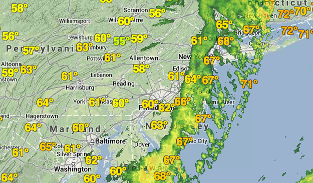
Radar imagery at 5:55 p.m. Monday. (Image: Weather Underground)
A day that began with muggy, tropical conditions will end on a much cooler, comfortable note.
As the once robust cold front quickly approaches the Delaware River, precipitation has ended in eastern Pennsylvania and the western half of New Jersey. Precipitation ahead of the front is quickly moving from west to east through the remainder of New Jersey.
With the exception of a few severe thunderstorm warnings issued in portions of central and northern New Jersey, most of the state saw storms ranging from mild to strong, despite some dramatic clouds appearing over some areas.
Damage from the few severe storms appears to be mostly isolated to Bergen County, where wind gusts toppled trees and ripped off the roof of a commercial building. Power outages in portion of the county continue. There were no immediate reports of injuries.
Gary Szatkowski, head meteorologist at the National Weather Service office in Mount Holly, NJ, said that there were factors that limited explosive storm development that once appeared possible when the National Weather Service Storm Prediction Center issued a Tornado Watch for the New Jersey region Monday morning.
No tornadoes formed in the New Jersey region today.
Storms did not get “tall enough” to “tap into the available wind shear,” Szatkowski tweeted in response to a query, adding that cloud cover was also a factor.
“Didn’t get much sunshine today. Needed more surface based instability,” he wrote.
Jersey Shore Hurricane News contributors reported minor coastal flooding in portions of Ocean County Monday afternoon. The National Weather Service advised earlier that the minor flooding was due to a strong southerly/southeasterly flow and continuing high tides following Friday’s new moon.
Jerry Meaney, a Point Pleasant first responder who also operates Barnegat Bay Island, NJ on Facebook, said that in Bay Head, “the usual spots were under water but it seemed a little worse than usual.”
But with winds shifting westerly Monday night, the possibility of further high water is “rather limited,” forecasters at the National Weather Service office in Mount Holly advised in the office’s latest forecast discussion.
Seasonable weather is on tap for Tuesday through the weekend, with temperatures topping out at the middle to upper 60s across the region.
WHYY is your source for fact-based, in-depth journalism and information. As a nonprofit organization, we rely on financial support from readers like you. Please give today.

