Planning Commission updated on North District plan, supports West Poplar and TOD zoning changes

Tuesday’s meeting of the Planning Commission unfolded briskly, with all of the bills considered by the commission getting recommended—with the exception of an “urban topiary encroachment” on 3rd Street just north of Girard Avenue, which PlanPhilly will explain in a separate story. In addition to several rezoning proposals, the commission also supported a long-simmering plan for the Frankford Creek Greenway, which would link the Tacony Creek Trail to the Delaware River Trail.
Philadelphia2035 Update: North District Plan
Planner Ashley Richards opened the meeting by presenting the nascent stirrings of the North District Plan, the third to last district plan, which applies principles from the city’s comprehensive plan to clusters of neighborhoods.
The North District lies between Kensington Avenue to the east, Lehigh to the south, Roosevelt Boulevard to the north and the Schuylkill River to the west. It contains many of the city’s poorest neighborhoods.
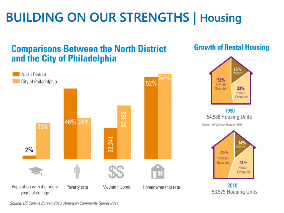
Richards laid out the basic demographics of the area for the commission. The North District is majority black, although 47 percent of residents identify as Latino. Only 2 percent of residents have college degrees, versus 23 percent for the city as a whole. Almost half the population lives below the poverty line and the median income is $22,000. The homeownership rate is nonetheless 52 percent, although that’s down significantly from 1990.
Thus far Richards has helmed one public meeting, with an impressive turnout of more than 100 residents. The number one concern raised by residents is the Conrail line, which is sunken below street level and provides shelter for drug use and selling. Used needles litter the ground and overdoses are common.
Other concerns include the open-air drug markets around the Fairhill neighborhood, illegal dumping, blight, and the lack of lighting under the Market Frankford line.
The area’s strengths are seen as the commercial district around Kensington and Allegheny (K&A), the Fifth Street business corridor, the two heavy rail SEPTA lines, Temple’s medical campus and the Lenfest Center, where Richards held the first community meeting about the plan.
The Planning Commission staff will try to narrow down the areas of focus for the North District plan over the next week in advance of the next community meeting in early May (exact day and time to be determined).
West Poplar rezoning
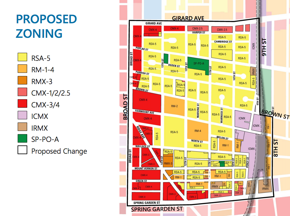
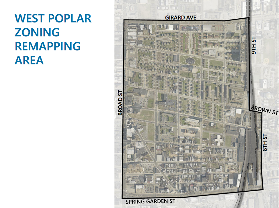
Planner Ian Litwin presented the remapping plan for the West Poplar neighborhood.
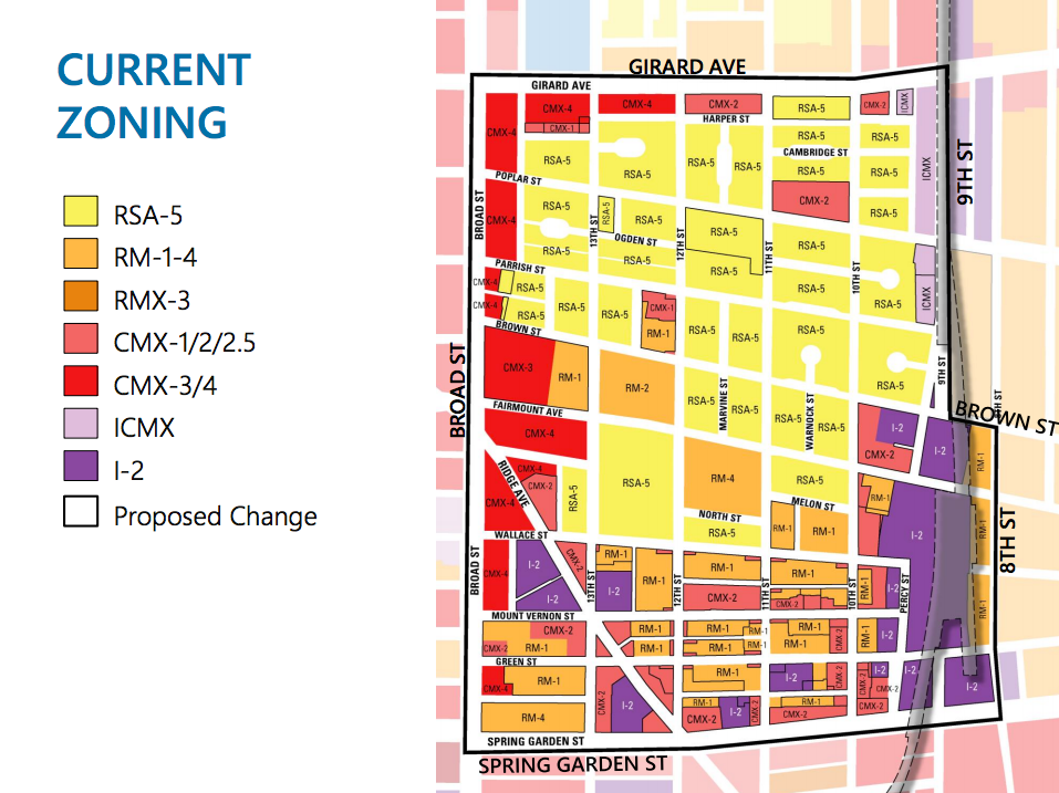
Currently the area along Broad Street and Spring Garden is zoned commercial, while other areas still retain industrial zoning. The residential areas are split between zoning to permit low-density single-family housing (RSA-5), where housing authority projects are the dominant form of housing, while to the south of Wallace the rowhouse areas are zoned RM-1 for residential multi-family.
“This area is seeing a lot of development pressure,” said Litwin. “What we are seeing is that the lots here are rather large, so when you have RM-1 zoning on large lots you can build a bunch of units with no parking and get things out of scale with the neighborhood.”
The bill would get rid of all the industrial zoning, along with much of the RM-1 and replace it with single-family zoning. The goals are to preserve the single-family homes in the heart of the neighborhood, encourage the residential reuse of former industrial buildings, and increase density around the main roadways (Broad and Spring Garden) and transit stations.
Litwin says that the bill has been in the works with Council President Darrell Clarke’s offices for two years.
Project Rezoning in Francisville
The next zoning bill Litwin introduced is of a more recent vintage. This one would remap an area bounded by 19th, Vineyard, Wylie, and Cameron streets. This triangular 1.5-acre of city-owned land is the only large and unused parcel in Francisville.
In 2009 the Office of Housing and Community Development put out a request for proposals for the parcel, which was won by the Hankin Group’s Cameron Square development.
Originally the project included a parking area enclosed behind 26 three-story townhomes and a four-story building with room for a small commercial use. The triangle got rezoned as RMX-3 and RM-1 to facilitate Hankin’s plans.
Then the project stalled out for eight years, but now they are back with a greater mixture of types of residential units. The bill would rezone the area CMX-3 to accommodate this new plan.
Gideon Edwards School rezoning
This bill would remap the area bounded by 29th Street and Sedgley, Ridge, and Glenwood Avenues. This area contains the Gideon Edwards School. Planner David Fecteau rushed to assure the commissioners that the school is in no danger.
“I want to put any rumors to rest: nothing is closing,” said Fecteau. “This school will continue to remain open, but a medical provider will locate in the school and provide services to the surrounding community as well.”
The school property is currently zoned for residential multi-family. (Most schools are zoned that way.) The bill would rezone it as industrial commercial, ICMX.
Fecteau said that it would be easy to think that commercial mixed use, CMX-2, might be better suited. But medical uses require special exemptions in that zoning classification. To avoid a trip to the Zoning Board of Adjustment, ICMX is a better fit.
Transit-oriented development overlay revisions
Commission staffer Mason Austin presented the reformed transit-oriented development (TOD) bill, which would revamp the confusing and unused provisions in the 2013 zoning code.
The bill doesn’t call for any specific stations to be granted a TOD overlay, it simply creates a no-frills mechanism that council people can use if they so desire. Under the new bill, an overlay would simply be comprised of every parcel that falls 500 feet of an entrance to a station.
“Currently there’s a complex TOD typology included in the code that makes it too complicated and difficult to understand,” said Austin. “This simplifies the provisions. It allows TOD areas to be added through a single addition to the code, rather than through complex remapping efforts.”
Any property in the overlay with higher-density mixed-use base zoning of CMX-3, CMX-4, CMX-5, or RMX-3 would get a 30 percent FAR bonus.
Additional density bonuses are included for developers who offer public space, underground parking, or transit connections—along with bonuses for green building and mixed-income housing that the current overlay grants. The number of allowable dwelling units will be increased by 50 percent for areas with a base zoning of CMX-1, CMX-2, CMX 2.5, or RM-1.
The bonus for mixed-income housing will be increased, from 150 percent of the base density allowed to 200 percent. Minimum height requirements would be set at 25 feet to prevent the construction of one-story buildings in a TOD overlay. Parking minimums in the overlay would be reduced, while the zoning code’s first maximum parking limit would be implemented (no more than 50 percent of the normal minimum allowed by the base zoning).
WHYY is your source for fact-based, in-depth journalism and information. As a nonprofit organization, we rely on financial support from readers like you. Please give today.
