Nor’easter to bring more rain to Philly region
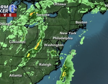
Heavy rain continues through the early morning hours with Flash Flood concerns east of the city.
This story originally appeared on 6abc.
Meteorologist Karen Rogers says the Philadelphia region will continue to see rain at times today with winds increasing late today and tonight.
Tuesday
Heavy rain continues through the early morning hours with Flash Flood concerns east of the city. Never drive through flooded water. It doesn’t rain all day. There will be a lull in the action where there’s just some rain in spots. The wind picks up this afternoon and another round of wind-driven rain returns tonight. Winds gust up to 30mph with some stronger gusts at the coast. High: 63.
Wednesday
A few early morning showers are possible. It’s still windy under mostly cloudy skies. High 68.
Thursday
Finally some improvement, with partly sunny skies and seasonable temperatures. High 64.
Friday
Another storm approaches the area bringing more rain, potentially steady at times later in the day. High 62.
Saturday
Mostly cloudy with a couple of showers possible. High 64.
Sunday
Clouds and some sun for the trick or treaters with a shower possible. High 62.
Monday
November begins with mostly sunny skies and a pleasant high of 63.
WHYY is your source for fact-based, in-depth journalism and information. As a nonprofit organization, we rely on financial support from readers like you. Please give today.
