NHC: Eastern Atlantic disturbance has a 70% chance of development within 5 days

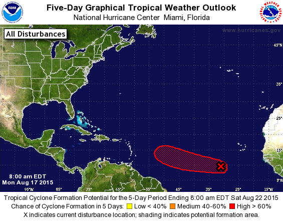
A National Hurricane Center graphic issued this morning indicates the forecast track of a a disturbance ("X") over five days with a 70% chance of development into a tropical system.
The National Hurricane Center is currently monitoring a disturbance in the Eastern Atlantic Ocean for possible development into a tropical system.
A low pressure system several hundred miles southwest of the Cape Verde Island is showing signs of organization, according to the center.
“Environmental conditions appear conducive for development during the next few days, and a tropical depression will likely form by the middle of the week while the system moves westward or west-northwestward near 15 miles per hour,” wrote the center’s Senior Hurricane Specialist Stacy R. Stewart in a bulletin issued this morning.
All global computer forecast models show the disturbance moving west-northwestward, keeping the storm over open waters all week.
The peak of the Atlantic hurricane season is on Sept. 10, which is the day when historically the maximum amount of convection and minimal amount of shear are found in the Atlantic basin, leading to the best chance of tropical system development.
The current season has featured three named storms — Ana, Bill, and Claudette — with Danny next.
The relatively quiet season is due to dry air blowing from Africa over the tropical zone and disruptive upper level winds, according to hurricane specialists.
With the season’s peak approaching, forecasters advise coastal residents to have a plan should a tropical system threaten or strike.
WHYY is your source for fact-based, in-depth journalism and information. As a nonprofit organization, we rely on financial support from readers like you. Please give today.

