


From lowly rail yards to high-end real estate: Dreaming of a transformed 30th Street Station District

The 30th Street Station District planning team held an open house at their namesake station yesterday, showing off a series of design elements organized into three diagrams in the hopes of determining development priorities based on public feedback.
Not all of us could drop everything to look at neat design posters on a Wednesday afternoon, so the planning team was gracious enough to share a presentation with PlanPhilly, and it is my humble honor to share some highlights with you now. You can check out the full presentation by clicking on the PDF links at the bottom of this article, and offer your thoughts to the planning team by emailing them at info@phillydistrict30.com.
-

(30th Street Station District Plan) -

(30th Street Station District Plan)
THE THREE DIAGRAMS: A DEVELOPMENT DREAM TRILOGY
As I noted earlier in the week, the idea isn’t to pick which of the three diagrams you like most. Rather, it’s to point out which elements in the diagrams you like the most, and which you could do without. The main purpose of this exercise is to figure out which design elements and planning details to prioritize.
Ultimately, the District Plan will provide a roadmap for developing the 175-acre area surrounding 30th Street Station, and for upgrades and renovations to the station itself. Each of the three diagrams contains elements aimed specifically at 30th Street and the wider neighborhood.
Should the District Plan promote a large capping of the rail yards and I-76? Should it create a “Sixth Square” to complement William Penn’s original five? What kind of uses should fill 30th Street Station’s relatively empty North Waiting Room?
While the three diagrams present distinct narrative visions for the district and the station, remember to not get too hung up on that. The three stories are: Central Business District 2, a sibling to Center City West’s and University City’s clusters of skyscrapers and office space; Schuylkill Crossing, a walk-able, mixed-use urban neighborhood, and; Innovation City, an R&D campus featuring an expensive, centrally located park.
-

(30th Street Station District Plan) -

Concept Vision Alternatives
And before we stroll through this trio of neighborhood concepts, let’s highlight some commonalities:
· Cap some part of the rail yards to the north and west of the station
· Develop the Amtrak maintenance yard that currently sits between the SEPTA tracks and the Amtrak tracks; this would not require capping.
· Convert all the roads surrounding the station to two-way streets.
· Install protected bike lanes on Market Street and some other streets in the area.
· Extend 31st Street between Market and Chestnut
· Extend JFK Boulevard to 32nd Street
· Build new north-south connections to the Spring Garden Street and I-76 ramps
It’s worth noting here that two of the diagrams provide for an intercity bus terminal adjacent to 30th Street Station. Currently, Philadelphia treats intercity buses the way I pack socks in a suitcase: blindly jamming them wherever they can fit without any forethought.
Today, Megabus, Boltbus and the Thruway buses operate just west of the station. Greyhound operates a terminal at 10th and Filbert, and the so-called Chinatown Buses use a parking lot on Arch for their operations. And around the corner from those, NJ Transit treats most of Market Street as an open-air bus terminal.
It’s a system without rhyme or reason crying out for some sort of organization. A large intercity bus terminal near 30th Street Station’s connections to SEPTA and Amtrak, not to mention easy access to I-76, would make a tremendous amount of sense, and alleviate large amounts of heavy traffic in Chinatown.
CENTRAL BUSINESS DISTRICT 2

This diagram proposes the most capping of the railyards, and capping of parts of I-76 to provide Philadelphia a bit of waterfront not dedicated to rapidly moving vehicles. To pay for those larger caps, it proposes the highest amount of development, 15-20 million ground square feet of new buildings.
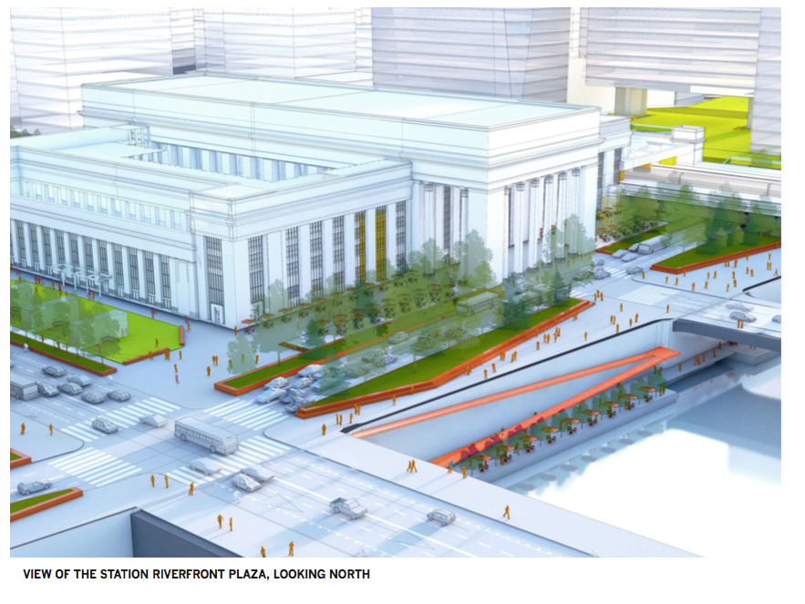
Above the newly-capped I-76, CBD 2 suggests placing an expansive, long park, a front lawn of sorts for a densely packed office district over the Amtrak rail yards. The park would start right at 30th Street Station’s front door, creating a large pedestrian, Dilworth-esque park where taxi pick up is today.
CBD 2 also suggests replacing much of the Cira Centre’s open air parking lot, where rental cars sit today, with a new North Station concourse. In all the proposals, 30th Street Station itself would expand to provide better access to longer platforms necessary for newer, lengthier high speed trains.
CBD 2 also proposes two of new bridges over the River, creating additional connections to Center City, one of which would be a pedestrian/bicycle bridge.
One easy to miss highlight: a floating park tucked underneath the JFK Boulevard Bridge connected to a western bank boardwalk running from Walnut Street to Spring Garden.
Even though “Business” is this diagram’s middle name, CBD 2 expects mixed-use development. Unlike many other cities, Philadelphia is almost completely devoid of exclusively office districts – a few blocks around Penn Center are about it, but even there, large apartments and condos are just a stone’s throw away.
CBD 2 offers the boldest vision of the three: the most new development, the most acreage of capped rail lines, and the most dramatic park spaces.
-

(30th Street Station District Plan) -

(30th Street Station District Plan)
SCHUYLKILL CROSSING
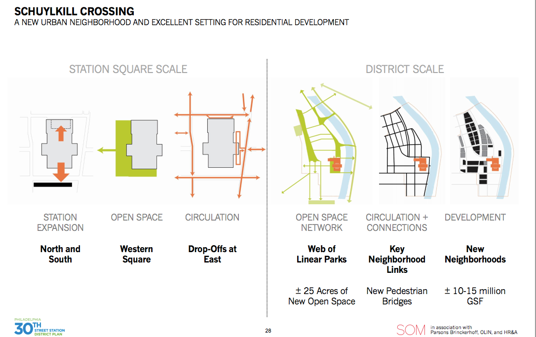
This diagram gets its name from the pair of new pedestrian/bicycle bridges it offers. Of the three, Schuylkill Crossing offers the second most space for new development: 10-15 million ground square feet, built largely over the capped Amtrak yards north of the station. The development would be the sort of mix of commercial and residential towers common throughout most of Center City.
It also proposes the least amount of park space, but creates a web of linear parks throughout the district, with one running along and above I-76, and another lining the western edge where Powelton Village and Mantua stand today, connected by tree-lined streets. In earlier planning stages, public feedback placed “more parks” second on the list of use priorities for the plan. Appropriate enough for Philly’s status as a foodie city, “restaurants” was the top choice.
-

(30th Street Station District) -

(30th Street Station District)
INNOVATION CITY
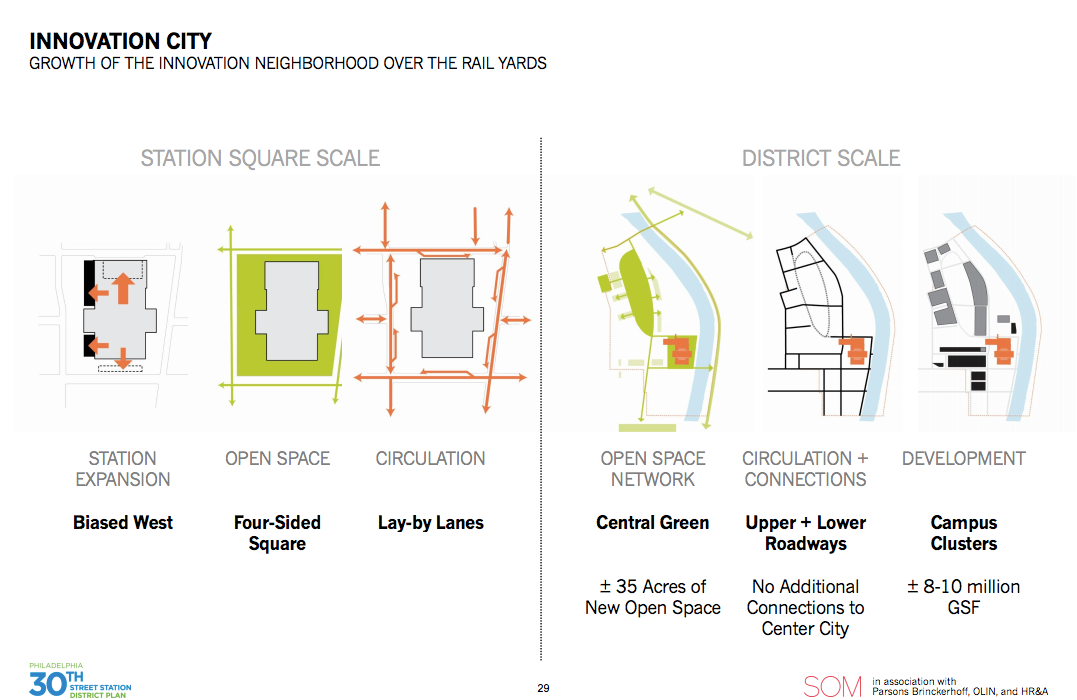
For a vision with a name as grandiose as Innovation City, this diagram offers the least ambitious set of plans. Still, a careful look at the elements reveals some interesting ideas – and, remember, that’s the entire point of this exercise.
Innovation City centers new develop around a massive, cantilevered central green where Amtrak maintenance facility lie now, between the SEPTA and Amtrak rail lines. It offers the least amount of rail yard capping and the least amount of new development space, 8-10 million ground square feet. It also wouldn’t provide any additional bridges to Center City.
It does propose, like Schuylkill Crossing, a new intercity bus terminal. Here, that terminal would replace the Cira Center’s front parking garage. In the Schuylkill Crossing diagram, the terminal would be in a similar location, but with direct access on the lower levels to I-76, and vertical development on the Arch Street level above.
Innovation City envisions a series of R&D campus developments, not unlike the new offices at the Navy Yard or Penn’s plans for the Pennovation Center across the river. Rather than massive caps above the existing rail lines, it would use skybridges and “Lincoln log” style stacked developments to span over the trains.
At the station itself, the Innovation City would provide the closest alternative to reopening the long-closed pedestrian tunnel linking 30th Street Station to the Market Frankford Line stop, by building a glass station expansion along the southwest corner with MFL access. This proposal also envisions effectively expanding the Porch to envelop the entire space surrounding the station, removing the confusing tangle of drop-off lanes and taxi stands strangling pedestrian access to the station.
-

(30th Street Station District) -

(30th Street Station District)
THE BEST LAID PLANS OF MICE AND MEN…
Notably absent from all these dreamy diagrams were cost estimates. It’s too early for that, said Natalie Shieh, Project Director for the 30th Street Station District Plan. At this stage, it’s about assessing what the public wants.
Also seemingly missing from the open house were representatives from the nearby Mantua community (neighboring Powelton Village appeared to be well represented among the mainly white, professionally dressed crowd of over 100). Councilwoman Jannie Blackwell, who represents the district and whose office the planning team has been working with to specifically engage with the lower income communities that will be impacted by any development, said there was still “plenty of time.”
“Therefore, there is plenty of time to take all the ideas and see how they can come together and come out again if need be to get the public opinion before any specific plans are made.”
All of these diagrams envision a massive transformation of a stretch of Philadelphia that is today little more than an industrial eyesore. It would flood not just this now empty expanse with tens of thousands of new residents and workers, but also the surrounding neighborhoods. Property values would need to rise as a condition precedent to the covering of any of the rail lines, in order to demonstrate to would-be developers that the massive investments would pay off.
Lower income residents would find themselves squeezed out by Drexel’s development to the south and west, and the District Plan’s development to the east. None of the diagrams designated new development for affordable housing.
Describing the diagrams as “exciting” and “wonderful”, Blackwell stressed the importance to not letting just one vision for the neighborhood dictate what eventually gets built.
“Philadelphia is really a city of neighborhoods,” Blackwell said. “It just doesn’t work if we don’t input every opinion. And if I get some of mine and you get some of yours, we can live with it. But it’s only when one side makes all the decisions we have problems.”
To see more, please check out the PDFs linked below. Submit your feedback on the 30th Street District Plan website here.
Open House Presentation 1 of 6
Open House Presentation 2 of 6
Open House Presentation 3 of 6
Open House Presentation 4 of 6
Open House Presentation 5 of 6
WHYY is your source for fact-based, in-depth journalism and information. As a nonprofit organization, we rely on financial support from readers like you. Please give today.
Brought to you by PlanPhilly

PlanPhilly
In-depth, original reporting on housing, transportation, and development.
Part of the series

Amazon rebuffs concerns over warehouse that sidelined land deal for SEPTA trolleys
Negotiations are still underway for a forthcoming community benefits agreement. Amazon said it did not intend to make major alterations to its proposal.
5 years ago

SEPTA to use COVID relief funds to move ahead with King of Prussia rail line
The $2 billion rail line would connect KOP to University City and Center City, creating a trifecta of the largest employment hubs in the region.
5 years ago

New SEPTA station in Claymont, Del. could kick-start revitalization
A train station planned for Claymont, Delaware, could be the catalyst for major redevelopment of the blue-collar town on the Pennsylvania border.
7 years ago