From Above: The Sugar House before SugarHouse, 1926

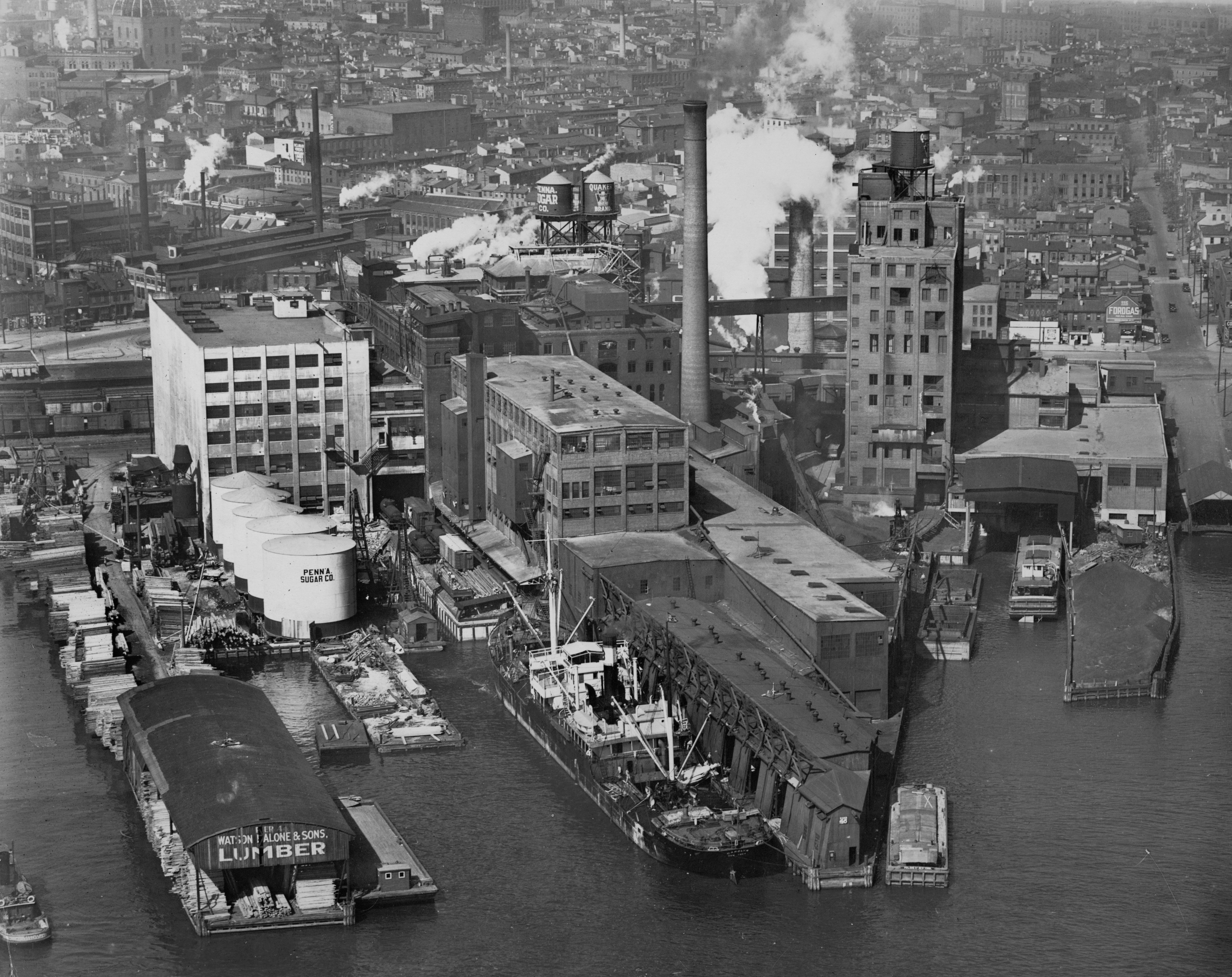
For this From Above we continue our look at the Central Delaware Waterfront in the 1920s with an up-close look at the original Sugar House at Delaware and Shackamaxon, and beyond to parts of Fishtown and Northern Liberties.
Long before there was the SugarHouse Casino, there was the Sugar House, a major sugar refining operation along the Delaware River between Frankford Avenue and Shackamaxon Street. In this aerial from October 5, 1926 we see the Pennsylvania Sugar Company’s operations at full steam. Philadelphia has a long history of sugar refining and this particular facility along the Delaware was started in the 1880s, and for decades was operated by the Pennsylvania Sugar Company. Over time the refinery complex grew to 18 buildings, ownership shifted and the workforce grew. Then in the early 1980s National Sugar Refining closed the refinery and sold the property. The buildings were demolished in 1997, and of course SugarHouse Casino stands on this site today.
If you look beyond and between the Sugar House and lumber pier in the foreground, you can see rail cars line up at the Shackamaxon Freight Yard. The street running parallel to the right hand side of the frame is Shackamaxon Street, and if you look closely you can just make out a sliver of the Edward Corner marine warehouse building that remains, waiting for reuse (fingers crossed, Mr. Samschick). Another piece of the neighborhood’s industrial past is the Ajax Metal Company’s factory building, which is getting lots of attention thanks to developer Michael Samschick’s big plans to turn the vacant building into a huge entertainment complex. Look to the left center of the frame for the Ajax building’s distinct double-monitor windows along the roofline and slender smoke stack. And what’s that tall, open-domed thing toward the top left of the frame? That’s the Schmidt’s Brewery clocktower.
Go on and kill a few Friday afternoon minutes – zoom in to see what you can discover.
———
This image is part of the Free Library’s Print and Picture Collection, and is used by PlanPhilly/Eyes on the Street with the express permission of Aerial Viewpoint, which owns these aerial images. For reproductions contact Aerial Viewpoint.
To learn more background about these aerial photographs, head over here.
WHYY is your source for fact-based, in-depth journalism and information. As a nonprofit organization, we rely on financial support from readers like you. Please give today.


